
Ashby Canal facts for kids
Quick facts for kids Ashby Canal |
|
|---|---|

The canal near Congerstone
|
|
| Specifications | |
| Length | 31 miles (50 km) |
| Maximum boat length | 72 ft 0 in (21.95 m) |
| Maximum boat beam | 7 ft 0 in (2.13 m) |
| Status | part open, part under restoration |
| Navigation authority | Canal & River Trust |
| History | |
| Principal engineer | Robert Whitworth |
| Other engineer(s) | Benjamin Outram |
| Date of act | 1794 |
| Date completed | 1804 |
| Date closed | 1944, 1957, 1966 |
| Geography | |
| Start point | Ashby-de-la-Zouch |
| End point | Marston |
| Branch of | Coventry Canal |
The Ashby-de-la-Zouch Canal is a 31-mile (50 km) long canal in England. It was built to connect the coal mining areas around Moira with the Coventry Canal at Bedworth. The canal opened in 1804.
To help move coal, special tramways (like early railways) were built near the northern end. The Midland Railway company took over the canal in 1846. It made good money until the 1890s, but then it started to decline.
About 9 miles (14 km) of the canal went through a coal mining area. The ground there often sank because of the mining, a problem called subsidence. Because of this, parts of the canal from Moira to Snarestone had to be closed in 1944, 1957, and 1966. This left about 22 miles (35 km) of the canal still open for boats.
Today, people are working to restore the closed parts of the canal. This project was the first canal restoration approved under a special law called the Transport and Works Act 1992. Some of the original canal path had been filled in or built over. So, the restoration involves building a new path through the town of Measham.
It is hoped that almost all of the canal can be reopened. A small section near Moira Furnace and the National Forest visitor centre was reopened between 1999 and 2005. This part of the canal now hosts an annual boat festival.
Contents
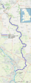
Exploring the Ashby Canal Route
The Ashby Canal begins where it joins the Coventry Canal near Bedworth. It then travels north-east for about 7 miles (11 km) through the town of Hinckley.
After Hinckley, the canal continues north for another 15 miles (24 km). This part goes through mostly quiet countryside until it reaches its current end at Snarestone.
Near Sutton Cheney Wharf, the canal passes close to Ambion Hill. This hill is famous as the site of the Battle of Bosworth Field, a very important battle in English history. At Shackerstone, the canal goes past the station that is the main office for the Battlefield Line Railway, a heritage railway.
History of the Ashby Canal
Why the Canal Was Built
In the late 1700s, there was a growing need to transport coal from Ashby Wolds and lime from quarries north of Ashby-de-la-Zouch. People started suggesting ideas for canals to move these materials.
In 1781, two main ideas came up. One was for a canal from Burton upon Trent to the Coventry Canal. The other was from Ashby Wolds to the Coventry Canal at Griff. The Coventry Canal company didn't like the first idea, but they were okay with the second.
Robert Whitworth, an engineer, estimated the second project would cost about £46,396. But the plan was dropped a year later. Other ideas for canals and tramways were suggested over the next few years, but none of them happened.
In 1792, Robert Whitworth updated his original plan. He suggested a flat canal from Griff to Ashby Wolds. From there, it would climb 139 feet (42 m) to a high point, with water supplied by a steam pump. After another 5 miles (8.0 km), the canal would go down 84 feet (26 m) to other branches. These branches would serve coal mines and quarries.
The total cost for these plans was estimated at £145,545. After some talks, the plan was changed so the canal would join the Coventry Canal at Marston instead of Griff. Finally, a law was passed in May 1794, allowing the company to raise money and build the canal. Robert Whitworth and his son were hired as engineers, and construction began.
Building the Canal
By 1796, it became clear that building the canal was costing much more than expected. Also, many people who promised to invest money didn't pay up. This meant the company had less money than they thought.
To solve this, the company decided to build tramways instead of some of the branch canals. Tramways were like simple railways used to carry goods. In 1797, Robert Whitworth Jr. became ill, and Thomas Newbold took over as engineer.
In 1798, the company asked Benjamin Outram for advice on the tramways. He suggested building them to Willesley Basin instead of Ashby Wolds, which would save over £8,000. The tramways ended up running from the basin through Ashby to a junction at Old Parks. From there, branches went to different coal mines and quarries. The total length of these tramways was about 12.5 miles (20 km).
Outram suggested making the tramway tracks wider than usual, at 4 ft 2 in (1,270 mm). He believed that railways would soon become the main way to transport goods. Even though wider tracks meant tunnels and bridges would cost more, his idea was accepted.
Building the tramways had challenges. The company wanted all parts built at once, which made it hard to supervise. They also often delayed decisions and payments, which caused problems for Outram. Despite these difficulties, the tramways were a big achievement and helped shape future railways.
Later Years and Railway Ownership

The tramways were finished by late 1802. The main part of the canal, from Marston to Moira, opened on April 19, 1804. There was only one lock, called a stop lock, at Marston. This lock helped control the water levels.
At first, the canal's finances were not good because many investors didn't pay their shares. The company had to borrow a lot of money. The coal mines also weren't producing enough coal to make the canal profitable right away. The total cost to build the canal was about £184,070.
However, traffic from the Moira coal pits grew steadily, especially in the 1820s. This helped the company pay off its loans and pay its first dividend (a share of profits to investors) in 1828. In 1819, the canal company and the Coventry Canal agreed to change the stop lock so only narrow boats could use it. This is a bit of a mystery, as wider boats still used the Ashby Canal, but they couldn't travel further.
In 1823, there were calls to build more tramways from the canal's end to Swadlincote and Church Gresley. The 3-mile (4.8 km) Swadlincote Railway opened in 1827. It had double tracks and used "edge rails," which are like modern railway tracks. Other tramway extensions were built later, including the Coleorton Railway in 1833.
In 1845, the Midland Railway company wanted to build a railway line and offered to buy the canal for £110,000. They promised to keep the canal working until the railway was built. Other canal companies were worried about losing business, so they made sure the railway company had to keep maintaining the canal. A law was passed in 1846, allowing the takeover.
The canal continued to carry a lot of goods, but the amount slowly decreased. By the 1890s, the railway owners reduced maintenance on the canal. In 1918, a large part of the canal embankment collapsed, costing nearly £10,000 to fix.
The upper section of the canal was increasingly damaged by ground sinking due to coal mining. In 1944, the London, Midland and Scottish Railway (LMS), who owned the canal by then, tried to give it to the Coventry Canal company. But they refused unless they also got money for maintenance. So, a 2.5-mile (4 km) section from Moira to Donisthorpe was closed. More sections were closed in 1957 and 1966.
Even today, you can still see parts of the old tramways, especially near Ticknall. There's a low bank with some stone blocks that were used for sleepers, and a tunnel under the drive to Calke Abbey. There's also an old arch bridge in Ticknall village where the line went into the quarries.
Restoring the Ashby Canal


When the canal closed north of Snarestone in 1966, the Ashby Canal Association was formed. Their goal was to prevent more closures and work to reopen the northern part. In 1992, a study showed that restoring the canal between Snarestone and Moira was possible.
By 1997, Leicestershire County Council had bought much of the canal's route. They found funding worth over £1 million. However, they couldn't agree with one landowner to buy a piece of land, and because of this, the funding was lost. So, they decided to get a special order under the Transport and Works Act 1992. This order would allow them to buy land even if the owner didn't want to sell, if it was needed for the project.
In 2000, the Ashby Canal Trust was set up to help with the restoration. It includes representatives from various groups, including the Canal & River Trust.
Since coal mining has stopped in the area, there are fewer problems with ground sinking. The current plan is to reopen the canal to the National Forest visitor centre at Moira. This is about 1 mile (1.6 km) short of its original end.
Between 1999 and 2005, a section of the canal near Moira was restored and filled with water. This part passes the historic Moira Furnace, an old iron furnace that is now a museum. This restored section is about 1.5 miles (2.4 km) long and includes a new lock.
Further down, the path of the canal is blocked by the A42 main road. In 2005, the special order to allow construction was granted. This order lets Leicestershire County Council buy land and build 2.5 miles (4 km) of canal from Snarestone to Measham. Part of this new canal will follow the original route, but it will also use an old railway track near Measham. This new canal will pass through Measham Station and cross the High Street on an aqueduct (a bridge for water).
The Transport and Works Act Order was created in 1992 to make legal processes simpler for railway and canal projects. The Ashby Canal Order was the first time this law was used to approve the building of a canal. By 2010, the land between Snarestone and Measham had been bought. Work on the first 100 yards (91 m) of the filled-in section began in 2009. This project included a stop lock, a new slipway, and a wetland nature reserve.
Progress on Restoration
In 2011, Leicestershire County Council made an agreement with UK Coal. As part of this deal, UK Coal would help with the canal restoration. They would change a road to let the canal pass under it and provide a water storage lake. They also agreed to give £1.28 million to help rebuild the section north of Snarestone.
Volunteers and contractors have been working on extending the canal towards Measham. In 2015, Bridge 62 was rebuilt, and a 50-foot (15 m) winding hole (a place for boats to turn around) was built just beyond it. This allows boats to use the new section. The next big project is to rebuild the Gilwiskaw Aqueduct.
In 2013, plans for the High Speed 2 (HS2) railway line caused some worries for the restoration. The original HS2 route would have gone through Measham, where a large housing development and canal basin were planned. This put the canal restoration in that area on hold.
Later, in 2016, revised HS2 plans moved the railway further east, crossing the canal's path on a viaduct. This gave hope that the canal extension to Measham could be completed. However, in 2017, the revised HS2 route was rejected. A new route was confirmed, which again went through the planned housing area. This caused the developers to cancel their project, meaning the canal restoration in Measham was put on hold again.
Despite this, the latest HS2 route might actually help in the long run. The HS2 project could fund bridges for the canal to cross under both the HS2 line and the A42 road when it is restored between Measham and Moira.
In 2020, the process of transferring the special Transport and Works Order to the Ashby Canal Association was almost finished. Once this transfer is complete, the association can continue with more restoration work.
Wildlife Along the Canal
The section of the canal between Carlton Bridge and Turnover Bridge is a special area for wildlife. It was named a Site of Special Scientific Interest in 1989. This means it's a very important place for nature.
This part of the canal has many different water plants and tiny animals without backbones (invertebrates). The plants that grow underwater are especially interesting. These include mare's tail, spiked water-milfoil, and perfoliate pondweed.
Nine different types of dragonfly have been seen here. You might also find water shrews and a rare type of water beetle called Haliplus mucronatus.
Images for kids
-
Geographic map of the canal (zoom in to see detail)
