
Mesopotamia, Oxford facts for kids
Quick facts for kids Mesopotamia |
|
|---|---|
.jpg)
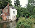
Looking north along Mesopotamia, with the main river channel to the left and the Kings Mill leat to the right
|
|
| Type | Public park on island |
| Location | University Parks, Oxford, England |
| Owned by | University of Oxford |
Mesopotamia is a beautiful and narrow river island located in Oxford, England. It sits right in the middle of the River Cherwell inside the University Parks. This island is a great place for students and families to explore nature.
Contents
Exploring the Island of Mesopotamia in Oxford
The island is about 800 yards long but very thin, only about 30 yards wide. It was created because the river flows in two different channels at different heights. One of these channels was once used to help power a large watermill.
What makes this island special?
Mesopotamia is what experts call an ait. An ait is a small island found in a river. A famous path called Mesopotamia Walk runs from one end of the island to the other. It connects the city center to a nearby area called Marston Road.
The History of Kings Mill
The site of the island has a very long history. A famous historical record called the Domesday Book mentions a mill here. This means people were using this spot as far back as the 11th century!
The mill building that stands today was built in the late 1700s. It was used to grind grain until 1825. Today, the mill is a private home and is protected as a Grade II listed structure. This means it is an important historical building that cannot be changed easily.
Why is it called Mesopotamia?
The name "Mesopotamia" comes from the Greek language. In Greek, it means "the land between rivers." This is a very fitting name because the island sits between two branches of the River Cherwell.
The name is also a reference to the ancient region in the Middle East. That famous area was located between the Tigris and Euphrates rivers. The Oxford island was named this way in the 19th century.
How the park was created
The University of Oxford bought the land between 1860 and 1865. They wanted to make the University Parks bigger for everyone to enjoy. The walking path was finished in 1865.
For a long time, people had to use a ferry to get across the water halfway down the path. In 1926, the ferry was replaced by a permanent footbridge. This made it much easier for people to walk through the park.
Gallery
-
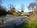
Kings Mill, viewed from the downsteam end of Mesopotamia
-
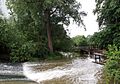
One of two overflow weirs that pass under bridges along the island
-
The upstream end of Mesopotamia seen from Parson's Pleasure


