Marston, Oxford facts for kids
Quick facts for kids Marston |
|
|---|---|
 St. Nicholas' parish church |
|
| Area | 2.92 km2 (1.13 sq mi) |
| Population | 3,398 (parish) (2011 census) |
| • Density | 1,164/km2 (3,010/sq mi) |
| OS grid reference | SP5208 |
| Civil parish |
|
| District | |
| Shire county | |
| Region | |
| Country | England |
| Sovereign state | United Kingdom |
| Post town | Oxford |
| Postcode district | OX3 |
| Dialling code | 01865 |
| Police | Thames Valley |
| Fire | Oxfordshire |
| Ambulance | South Central |
| EU Parliament | South East England |
| UK Parliament | |
| Website | Old Marston Parish Council |
Marston is a village located about 2 miles (3.2 km) northeast of the city of Oxford, England. It is often called Old Marston to help tell it apart from New Marston, a newer area that grew up nearby. The village became part of Oxford city in 1991.
The A40 Northern Bypass, which is part of the Oxford Ring Road, forms a long boundary on the north-west side of the village. Also, a branch of the River Cherwell forms the western border of Marston.
Contents
Marston's Past: A Village Story
The name "Marston" probably comes from "Marsh-town." This is because the land near the River Cherwell was often wet and marshy. It used to flood a lot in earlier times.
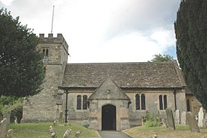
Marston was once part of a larger area called the manor of Headington. The local church, St Nicholas, started as a small chapel. It was first mentioned in a document from 1122. This document gave the chapel to a group of religious people called the Augustinians canons of St Frideswide's Priory. The church building itself dates back to the 12th century, with more parts added in the 15th century.
Marston and the English Civil War
Marston played an important role during the English Civil War. This war was fought between King Charles I's Royalist forces and the Parliament's forces. Oxford was King Charles I's capital city at the time.
During the siege of Oxford, the Parliament's army, led by Sir Thomas Fairfax, stayed in Marston. They used the church tower as a lookout spot. From there, they could see the enemy's cannons in what is now the University Parks.
Oliver Cromwell, a famous leader of the Parliament's army, visited Fairfax at a house in Marston. This house is now known as "Cromwell House." In 1646, an important agreement called the Treaty for the Surrender of Oxford was signed there. This treaty ended the fighting in Oxford.
Marston's Growth and Famous People
In the 20th century, Oxford city grew a lot. New houses were built along Marston Road, connecting the village to the city. Marston soon became part of Oxford. New Marston became its own separate parish in the 1950s. Old Marston parish officially joined the City of Oxford in 1991. However, it still has its own local council.
Marston has been home to several notable people. This includes members of the Oxford team who worked on penicillin. These were Howard Florey, his second wife Margaret Jennings, and Norman Heatley. The village is also connected to the origin of the Jack Russell Terrier dog breed.
Getting Around Marston
A special cycle route connects Marston to central Oxford. This path goes through the meadows west of New Marston. It crosses the River Cherwell over a bridge. Then it passes the southern edge of The Parks and ends near the Science Area of Oxford University.
You can also walk on footpaths across the meadows to The Parks. These paths include the Mesopotamia Walk and the Rainbow Bridge.
 | Georgia Louise Harris Brown |
 | Julian Abele |
 | Norma Merrick Sklarek |
 | William Sidney Pittman |


