
River Brent facts for kids
Quick facts for kids Brent |
|
|---|---|

River Brent at Brentford
|
|
| Country | England |
| Counties | Greater London |
| Districts / Boroughs | London Borough of Barnet, London Borough of Brent, London Borough of Ealing, London Borough of Hounslow |
| Towns | Hendon, Neasden, Perivale, Greenford, Hanwell |
| Physical characteristics | |
| Main source | London Borough of Barnet, Greater London |
| River mouth | River Thames Brentford, Greater London |
| Length | 29 km (18 mi) |
| Discharge (location 2) |
|
| Discharge (location 3) |
|
| Basin features | |
| Tributaries |
|
The River Brent is a river in west and northwest London, England. It is a smaller river that flows into the famous River Thames. The Brent is about 17.9 miles (28.8 km) long. It starts in the Borough of Barnet and flows mostly southwest. Finally, it joins the Tideway part of the Thames in Brentford.
Contents
- What's in a Name? The River Brent's History
- How the River Brent Was Formed
- Human History Along the Brent
- Where the River Brent Flows
- Industrial History Along the Brent
- Parks and Nature Along the Brent
- Important Buildings Near the River
- Environmental Concerns
- Bringing the River Back to Life
- Times the River Brent Flooded
- The Brent in Books and Poems
- Images for kids
- See also
What's in a Name? The River Brent's History
The name of the River Brent is very old. The earliest mention of the area is from a letter in 705 AD. It talks about a meeting at Breġuntford, which is now Brentford. This suggests the river's name might come from an old Celtic word, brigant-. This word means "high" or "elevated." It might even be linked to an ancient goddess named Brigantia.
How the River Brent Was Formed


The River Brent and its valley were shaped by huge ice ages. These ice ages started about 500,000 years ago. Before this, the main river in this part of England, called the proto-Thames, flowed much further north. It was about 25 miles (40 km) north of Brentford.
About 450,000 years ago, a giant ice sheet (a huge mass of ice) arrived. It blocked the river in Hertfordshire, creating large ice lakes. When these lakes burst, they forced the Thames to change its path. This is how the Thames ended up flowing through London as it does today.
The ice sheet also pushed the northern river channel south. This created a lake, which is now the St Albans depression. This pressure helped form the Goring Gap. A new river route then formed through Berkshire, joining the Kennet. This new path led into London.

The ice sheet stopped near Finchley. It left behind a type of clay called Boulder clay. This clay formed hills like Dollis Hill and Hanger Hill. Meltwater from the ice sheet rushed through the Finchley Gap. It flowed south towards the new Thames path. This powerful water carved out the Brent Valley.
The valley sides are steep because the sea level was much lower back then. This was because so much water was locked up in glaciers. The river water flowed very fast to the sea, cutting its bed quickly downwards. Over time, the Brent Valley has been filling up with silt. This creates the rich, wet meadows you can see today. These meadows often flood, adding more soil.
Human History Along the Brent
Early Times to Norman History
It's hard to find signs of early humans near the Brent. Any evidence from before the ice age was likely moved by water. Even later signs of people might be buried under layers of silt.

The most important early settlement on the River Brent was at Brentford. This place was settled in the Bronze Age, even before the Romans came to Britain. Many old objects have been found there. These finds suggest that Brentford was a meeting place for ancient tribes. One famous item is the Brentford horncap, an Iron Age chariot part.
The River Brent was likely a wide, shallow river before modern changes. It would have flooded often, creating swampy areas. These swamps would have been bordered by thick bushes and willow trees. The river probably acted as a natural border between different groups of people. For example, in 705 AD, a meeting was held at Brentford to settle a dispute between the East Saxons and West Saxons. This shows the Brent was seen as a good halfway point or boundary.
The village of Hanwell was first mentioned in 959 AD. It was a small hamlet on the riverbanks. Some people think the name "Hanwell" comes from Saxon words meaning "boundary stone" and "fresh water spring." This suggests the river was an important marker.
The Brent River also marked the boundary between lands named by the invading Saxons to the west. To the east, lands kept older names from Roman-British London.
After the Normans Arrived
The river continued to mark important boundaries. It separated Middlesex and Hertfordshire. It also marked the edge of smaller areas like Gore Hundred.
In the Middle Ages, malaria was common in Britain. It affected people living near marshy areas like the Thames and its tributaries. This might have made people think of the riverbanks as unhealthy places to live.
The river was also a good natural defense. There were only a few safe places to cross it. These crossing points, or fords, later became bridges. Examples include the Roman road crossing in Brentford and Hanwell Bridge on the Uxbridge Road.
The London Borough of Brent got its name from the river in 1965. This happened when the boroughs of Willesden and Wembley joined together. The borough's coat of arms even shows a wavy line representing the river.
Where the River Brent Flows
From Source to Brent Reservoir


The River Brent officially begins where two streams meet: Dollis Brook and Mutton Brook. This spot is near Bridge Lane in Hendon, in the London Borough of Barnet.
- Dollis Brook is about 6 miles (10 km) long. It starts in Moat Mount Open Space and flows east. It passes through fields and open spaces before turning south. A smaller stream called Folly Brook joins it near Woodside Park tube station.
- Mutton Brook starts in Cherry Tree Wood, East Finchley. It flows underground for a bit before coming to the surface. It then flows through parks and meets Dollis Brook.
Other small streams also join the Brent. Decoy Brook flows from Turner's Wood in Hampstead Garden Suburb. Clitterhouse Stream starts on the western slopes of Hampstead Heath. This stream flows underground and then joins the Brent near Brent Cross shopping centre.
The River Brent then flows next to the A406 North Circular Road. It goes under the Northern line train tracks to Brent Cross. Here, another important stream, the Silk Stream, joins it. The Silk Stream has its own smaller branches, like Burnt Oak Brook and Edgware Brook.
From Brent Reservoir to Brentford

After the Brent Reservoir, the river continues to follow the North Circular Road. It passes Stonebridge Park, south of Wembley. It then flows under an aqueduct that carries the Paddington Arm of the Grand Union Canal.
From Stonebridge Park, the river turns west. It flows under the A40 Western Avenue. It then goes through Tokyngton Recreation Ground in Harlesden and the Brent River Park. It continues for three miles to Perivale.
The river then runs through Perivale Park. It goes under a railway bridge and through Perivale Lane. Here, it joins a foot and cycle path that leads to Pitshanger Park. This part of the river was made deeper in the 1960s to help prevent flooding.
The river then swings south again at Greenford Bridge towards Hanwell. It flows past St. Mary's Church. It also goes under the famous 900-foot-long (270 m) Wharncliffe Viaduct. This is a tall railway bridge that carries the main train line from Paddington.
About 500 m (550 yd) further, the main Grand Union Canal joins the River Brent. This happens at the bottom of the Hanwell flight of locks. From this point, the Brent becomes a canal and is navigable. The river and canal pass through several locks. Finally, the Brent joins the tidal River Thames at Brentford, about a mile upstream from Kew Bridge.
Industrial History Along the Brent
Brentford Dock

Brentford Dock was a very important place in west London. It was where goods were moved between the Great Western Railway (GWR) and barges on the River Thames. Building the dock started in 1855 and it opened in 1859. The dock area was rebuilt in 1972. Now, it is the Brentford Dock Marina and Brentford Dock Estate, with modern homes.
Brent Reservoir

The Brent Reservoir is often called the Welsh Harp Reservoir. It sits on the border between the London boroughs of Brent and Barnet. It is owned by British Waterways. The reservoir gets its informal name from an old pub called The Welsh Harp that used to be nearby.
The reservoir was built to make sure there was enough water for the Grand Union Canal and the Regent's Canal. This was especially important during dry weather. The Regent's Canal Company decided to build a dam on the River Brent to create the reservoir.
The reservoir was built between 1834 and 1835. It flooded a large area of farmland. It was first called "Kingsbury Reservoir."
Parks and Nature Along the Brent
Lower Dollis Brook Nature Area
Near its source in Hendon, the river flows through Brent Park. This park and the first part of the river are part of the Lower Dollis Brook nature area. This area is important for nature conservation.
Brent River Park

Brent River Park is one of London's big green spaces. It's a natural area that has been improved. A new cycle path and wildlife areas were opened in 2008. The park is popular with people walking, dog walkers, and nature lovers.
The entire Brent River Park is now a nature conservation area. It even won an award in 2009, getting £400,000 for park improvements. The park is full of different plants and animals, including bats.
Perivale East Meadow and Pitshanger Riverside Meadows
These three meadows are part of Brent River Park. They have natural riverbanks and are part of the River Brent flood plain. You can see many birds here, like mallard ducks, moorhens, kingfishers, and grey wagtails. Herons are also sometimes seen along the river.
Tokyngton Park
The River Brent also flows through Tokyngton Park in Tokyngton, Brent. In the past, this part of the river was straightened and put into concrete channels to prevent floods. This made it less enjoyable for people and not good for wildlife.
However, in 1999, local groups worked together to improve the park. They wanted to make it better for both people and wildlife. The goal was to remove the concrete and create a more natural river with new bends.
Brent Lodge Park and the Churchfields
Brent Lodge Park (or BLP) and Churchfields are located within the Brent River Park. This area feels like a piece of the countryside inside the city of London Borough of Ealing. The River Brent borders the park on the west and south. It's a favorite spot for locals to relax.
The park received a Green Flag Award in 2009. Volunteers from the Brent River and Canal Society help look after the park. This park has public toilets, a café, an animal center, and a Millennium maze. Its large hay meadows and trees are great for spotting different plants and animals.
Wembley Riverside Walk
There is a public path called the Wembley riverside walk that leads to Wembley Stadium. Other cycling routes also follow parts of the River Brent. These paths are well-made and let you walk or cycle close to the river.
Important Buildings Near the River

Ealing Hospital was rebuilt in the 1970s near the River Brent. It is on the same site as St Bernard's Hospital, Hanwell, which dates back to 1832.
In Brent Lodge Park and the Churchfields, there is a Grade 2 listed stable block. This building now houses an animal center. It is the only part left of an old manor house that burned down in the 1930s.
Environmental Concerns
Pollution in the River
The River Brent has had pollution problems for a long time. In 1886, it was badly polluted by sewage, rubber factories, and early oil industries. Today, more cars on the roads also contribute to pollution upstream.
High levels of sewage killed off local trout in Brentford by the early 1920s. The river was cleaned, and sewage was sent into a separate underground pipe by World War II. A few trout started to return in the 1990s.
Even in 2010, parts of the river were affected by pollution from city runoff and wrongly connected drains. For example, a collapsed sewer pipe in Ealing in 2010 showed that some houses built in 2000 were not properly connected to the sewage system. Their waste had been flowing into the River Brent for 10 years!
Flood Prevention Work
Most of the river's banks were built up or "corseted" in the 20th century. This helped control the water flow and create dry land. The river used to be about 5 feet (1.5 m) deep, rising to 14 feet (4.3 m) during floods.
Much of the local flood prevention work happened from the 1940s to the 1970s. The Brent flood prevention plan was finished in the 1980s. This helped protect homes and roads from flooding. Some parts of the river that were buried under concrete were planned to be uncovered in 2008 to make the area more natural.
Bringing the River Back to Life
The Brent River and Canal Society (BRCS)
The Brent River and Canal Society (BRCS) is a group of volunteers. It was started in 1972 by residents of Hanwell. They began by cleaning up two years' worth of rubbish from the river.
In the 1970s, the society worked hard to create Brent River Park. The park was set up in 1975. This saved the area from being used for a large flood prevention scheme. The society wanted a continuous walking path along the river from Hanger Lane to Brentford.
The first part of this path was called Fitzherbert Walk. It opened in 1983 and was named after Luke Fitzherbert, one of the society's founders. Another footpath under the Wharncliffe Viaduct opened in 1985. It is now part of the Capital Ring, a recognized national walking route.
Local Community Projects
People often organize clean-up events along the river. For example, in August 2010, volunteers cleared litter from the river and its banks in Brent Lodge Park. This helped improve the area for both people and wildlife.
School children from Alperton Community School have also been involved. They worked with the Environment Agency to teach people not to pollute the Wealdstone Brook and River Brent. They explained that litter and improper waste disposal harm fish.
In February 2011, several community projects started to clean up the River Brent. These projects aimed to protect fish spawning grounds.
The 'River Brent Project'


The 'River Brent Project' is a plan to improve the local environment. It aims to help wildlife, prevent floods, and make the area better for people. You can find more information about these projects on the River Restoration Website.
Here are some of the project goals:
| Project location | Main project goal. |
|---|---|
| Boston Manor | biodiversity (variety of life) |
| Hanwell meander | fishery (fish habitats) |
| Greenford | flood prevention |
| Brent Loge Park | urban renewal (improving city areas) |
| Tokyngton Park | urban renewal |
| Wembley industrial estate | global warming (related improvements) |
| Kingsbury Park | biodiversity |
| Gadder brook | habitat (natural home for animals) |
| Brent Cross | global warming |
| Brent Reservoir waterscape and reed bed | habitat |
| Golders’ Green | drainage diversion (changing water flow) |
| River Brent Business Park | drainage diversion |
| Silk stream's toe board | biodiversity |
| Wealdstone brook | urban renewal |
| Edgware brook | biodiversity |
| Barnet | industrial drainage diversion |
| Edgware Park FSA | flood prevention |
| Mill Hill | domestic sewage and drainage diversion |
| Burry Farm FSA | flood prevention |
| Belvedere Way, Kenton | culvert uncovered (bringing buried river sections to the surface) |
Work at Tokyngton Park, Brent
As mentioned, the River Brent in Tokyngton Park was once straightened and put into concrete. This made it less appealing and bad for wildlife. In 1999, a local partnership formed to improve the park.
They hoped to give the river a new life by removing the concrete banks. The plan was to create new bends in the river's course. This would make the park a more attractive public space. It also aimed to encourage local people to get involved in the project.
Times the River Brent Flooded
The earliest record of a flood on the Brent is from 1682.
- 1682: A very strong storm caused a sudden flood. It badly damaged the town of Brentford. The whole town was underwater, and boats could row through the streets. Some houses were even washed away.
- 1841: Brentford flooded because the Brent Reservoir became too full. The overflow broke a hole in the earth dam. A huge wave of water rushed down the river, causing deaths.
- 1976 and 1977: After a long drought, heavy rain caused the Brent reservoir to overflow. Authorities opened the floodgates to prevent worse damage. However, local sewers overflowed, and some homes were flooded. Streets were jammed, and trains were blocked.
- 2007: Heavy rain in August caused quick floods in Brentford and Hanwell. Roads, train lines, and the London Underground were affected.
- 2009: On November 30, the Environment Agency warned people about flooding along the River Brent. This was after a day of very heavy rain. Several buildings in Brentford and Perivale were temporarily flooded.
The Brent in Books and Poems
The famous poet John Betjeman wrote about the River Brent in his poem "Middlesex":
Gentle Brent, I used to know you
Wandering Wembley-wards at will,
Now what change your waters show you
In the meadowlands you fill!
Recollect the elm-trees misty
And the footpaths climbing twisty
Under cedar-shaded palings,
Low laburnum-leaned-on railings
Out of Northolt on and upward to the heights of Harrow hill.—John Betjeman
In the novel Rivers of London, the river is imagined as a person. The River Brent appears as one of the daughters of "Mama Thames."
Images for kids
-
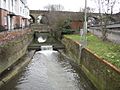
River Brent at Brent Cross. The Ordnance Survey 1:50,000 scale mapping shows a sea of dark green here as the A406 North Circular Road and the A41 Hendon Way meet at the Brent Cross Flyover. A small weir impounds a head of water as the river flows down towards the Brent Reservoir.
-
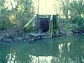
A surface water drain outflow into the River Brent on the right hand bank.
-
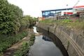
The River Brent at Vicar's Bridge, Alperton. Here the river serves as the boundary for two London boroughs: Ealing (left bank) and Brent (right bank).
-
An assumed surface water storm drain discharging into the river.
-
The River Brent at Hanwell Bridge, Hanwell, W7 See 205141 for view from bridge on the opposite side of the road.
-
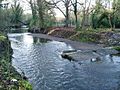
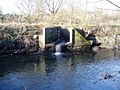
Remains of a weir on the River Brent Looking westward from the right hand bank.
-
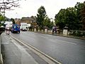
Hanwell Bridge, Uxbridge Road as it crosses the River Brent, looking east.
-
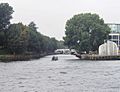
The confluence of Rivers Thames and Brent. The motorised barge is heading up the River Brent. From this point as far as Hanwell the Brent has been canalised and shares its course with the main line of the Grand Union Canal. From Hanwell the Brent can be traced to various sources in the Barnet area.
-
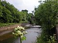
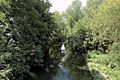
River Brent near Greenford.


See also
 In Spanish: Río Brent para niños
