
Perivale facts for kids
Quick facts for kids Perivale |
|
|---|---|
 Skyline of Perivale; the steep slope in the background is part of Horsenden Hill |
|

Perivale
|
|
| Population | 15,339 (2011 Census. Ward) |
| OS grid reference | TQ165835 |
| London borough | |
| Ceremonial county | Greater London |
| Region | |
| Country | England |
| Sovereign state | United Kingdom |
| Post town | GREENFORD |
| Postcode district | UB6 |
| Dialling code | 020 |
| Police | Metropolitan |
| Fire | London |
| Ambulance | London |
| EU Parliament | London |
| UK Parliament |
|
| London Assembly |
|
| Councillors |
|
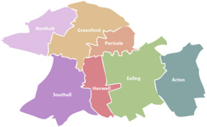
Perivale is an area in Greater London, located about 9.5 miles (15.3 km) west of Charing Cross. It is the smallest of the seven towns that make up the London Borough of Ealing.

Perivale is mostly a residential area. It has a library, a community centre, and many parks. There is also a large industrial area. Important buildings include the Art Deco Hoover Building. This building is very old and special. St Mary's Church is also here, built around the 12th century. You can also visit Horsenden Hill park and Perivale Wood Local Nature Reserve. Perivale is part of the UB6 postcode area, along with Greenford.
Contents
What Does the Name Perivale Mean?
The name Perivale was first used in 1508. It was spelled "Pyryvale" back then. The name likely comes from "perie," meaning pear tree, and "vale," meaning a wide valley.
Before 1508, Perivale was often called "Little Greenford." This helped people tell it apart from its bigger neighbour, Great Greenford.
Perivale's Past: A Brief History
Perivale was once a very small parish (a local area) in Middlesex county. Until the early 1900s, it was one of the smallest parishes. It covered about 633 acres (2.56 km²) and had very few people living there.
Early Days and Farming Life
.jpg)
St Mary's Church is one of London's oldest churches. It dates back to at least the early 1200s. The church is located south of the A40 road. Perivale was mainly a farming area from the 1300s. It had woodlands and fields used for growing crops.
In the 1400s, a large three-storey house called Perivale Manor was built. It was surrounded by a moat, gardens, and orchards. This manor was near St Mary's Church but was taken down around 1784.

From the 1500s, wheat was the main crop. Perivale became known for its high-quality wheat. Later, during the Industrial Revolution, much of Perivale's land grew grass for hay. This hay was used to feed horses in London.
The Grand Union Canal was built in 1801. It still runs through Perivale today. This canal made it easy to transport hay, increasing demand. By 1839, almost all of Perivale's land was used for growing hay.
Perivale's population stayed very small for a long time. In 1801, only 28 people lived there. By 1901, the population was still only 60 people.
Growing Up: Perivale in the 1930s and Beyond
Things changed a lot with new transport links. The A40 Western Avenue was built, cutting through Perivale. Perivale also got connected to central London by train. This was through Perivale train station and Alperton-Perivale Station (now Alperton Underground Station).
These transport links helped Perivale grow quickly. Many factories and houses were built. Houses first appeared around Horsenden Lane South and Bilton Road. The Medway Estate was also developed.
Big factories like Sanderson Wallpapers Ltd (1929) and the Hoover Building (1932) opened. The Hoover factory made vacuum cleaners and other home appliances. At its busiest, it employed over 3,000 people. These factories were known for good working conditions. Workers could buy affordable homes nearby. By 1951, Perivale's population had jumped to 9,979 people.
The Hoover Factory closed in the 1980s. Part of the building became a Tesco supermarket. The upper parts of the main building were recently turned into fancy apartments.
Who Lives in Perivale?


The 2011 census showed that many different groups of people live in Perivale. The largest group was "Other White" (22%). This was followed by "White British" (20%) and Indian people (15%). Perivale has the most Polish residents in London. Because of this, Polish is the most spoken foreign language.
Many people in Perivale own their homes (62%). About 27% of homes are rented privately. Only 9% of homes are social housing.
Perivale's Location and Shops

Perivale is mainly a place where people live. However, you can find local shops at Medway Parade and on Bilton Road. Perivale also has two industrial estates. These are Perivale Park and Perivale Industrial Estate.
Fun Things to Do in Perivale
Culture and Leisure
Perivale Library and Perivale Community Centre are both on Horsenden Lane South. The BBC Archives are also located in Perivale.
You can enjoy walking and cycling along the Grand Union Canal. This canal runs through the north of Perivale. London's Capital Ring, a walking route, also passes through Perivale along the canal.
Other parks include Ealing Central Sports Ground and Perivale Park. Perivale Park has an athletics track, a gym, a golf course, and tennis courts. It also has ponds, a memorial bench for musician Nicky Hopkins, and an orchard garden.
Perivale Wood: A Special Nature Spot
Perivale Wood is one of Britain's oldest Local Nature Reserves. It has been managed since 1902 and was officially named an LNR in 1974.
The wood is bordered by the canal to the north and the Central line railway to the south. It is 11.6 hectares (28.7 acres) in size. It is mostly old oak woodland, with grassy areas, ponds, and streams. You can find the entrance in Sunley Gardens.
Horsenden Hill: A Big Park to Explore
Horsenden Hill is a large park and nature reserve. It is located at the northern edge of Perivale. The park has playgrounds for children and a "The Gruffalo Trail." The old Horsenden Farm house is also there. It is home to groups like Perivale Brewery and Ealing Canoe Club.
The "Lower Thrifts" part of Horsenden Hill hosts Perivale's annual End of Summer Festival in September.
Sports in Perivale
Perivale has two golf courses: Ealing Golf Club and Perivale Golf Course. The football club Hanwell Town F.C. has played in Perivale's Reynolds Field since 1981. This field is also used by St Benedict's for sports.
Schools in Perivale
Perivale has four primary schools: Perivale Primary School, St John Fisher Catholic Primary School, Selborne Primary School and Vicars Green Primary School.
Getting Around Perivale: Transport Links
Perivale has great transport links to central London. You can easily get to other parts of Ealing and west London too.
By Road
You can reach central London easily by car using the A40 Western Avenue. This major road runs through Perivale. The Hanger Lane gyratory system, just east of Perivale, connects to the North Circular Road.
Public Transport
Perivale Underground Station is in the centre of Perivale. It is on the Central line. Trains run very often, connecting Perivale to places like Westfield London (11 minutes to White City station), Notting Hill Gate (17 minutes), and Marble Arch (22 minutes).
Alperton Underground Station is also nearby. It is on the Piccadilly line and connects to Uxbridge, Hammersmith, and central London. South Greenford Railway Station is just outside Perivale.
Three bus routes serve Perivale:
- The 297 bus runs 24 hours a day. It goes through Perivale Station to central Ealing and northwest London.
- The 95 bus runs along the A40 to Shepherd's Bush.
- The E5 bus serves the Medway Estate and Perivale Tesco, going to Southall.
By Canal
The Grand Union Canal, Paddington Branch, runs through Perivale. It offers paths for walking and cycling. It is also part of the Capital Ring walking route.
Perivale in Books and on Screen
Perivale has appeared in several books and TV shows:
- It is one of the places in Anthony Trollope's novel The Belton Estate (1865).
- Poet John Betjeman described Perivale as a "parish of enormous hayfields" in his 1954 poem Middlesex.
- Perivale was the hometown of Ace, a companion in the Doctor Who TV show. Many scenes for the 1989 episode Survival were filmed here.
- Parts of the movie Snatch were filmed in Perivale and on Horsenden Hill.
- Henry Perowne, a character in Ian McEwan's novel Saturday, was born in Perivale.
- Only Fools and Horses filmed scenes on Horsenden Hill.
Famous People from Perivale
Many well-known people have connections to Perivale:
- Tina Daheley, a BBC journalist, lived in Perivale.
- Alan Devonshire, a former West Ham and England footballer, lived here.
- Neal Foulds, a snooker player and commentator, lived in Perivale.
- Leena Gade, the first female race engineer to win the 24 Hours of Le Mans, was born here.
- Kerry Godliman, a comedian and actor, was born in Perivale.
- Nicky Hopkins, a famous session pianist (who played for The Kinks, The Beatles, and The Rolling Stones), was born in Perivale.
- Lee McQueen, winner of The Apprentice in 2008, was born in Perivale.
- Carole Middleton, mother of The Duchess of Cambridge, was born in Perivale.
- Tom Newman, a record producer (who produced Mike Oldfield's Tubular Bells), was born here.
- Richard Oakes, guitarist for the band Suede, was born in Perivale.
- Janet Street-Porter, a journalist and TV personality, lived in Perivale.
- Rick Wakeman, musician and keyboardist for Yes, was born in Perivale.
- Robin Leach, an American entertainment reporter, was born in Perivale.
Nearby Places to Perivale
 |
Horsenden Hill, Greenford Green, Northolt | Horsenden Hill, North Greenford, Sudbury | Sudbury/Alperton, Wembley | |
| Greenford Green, Northolt | Alperton, West Twyford/Park Royal | |||
| Greenford Broadway/Hanwell | Pitshanger, West Ealing | Pitshanger, Ealing |
Images for kids
-
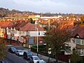
Skyline of Perivale; the steep slope in the background is part of Horsenden Hill
