
Northolt facts for kids
Quick facts for kids Northolt |
|
|---|---|
 Northolt Green and the clock tower |
|

Northolt
|
|
| Population | 30,304 (2011 Census) |
| OS grid reference | TQ135845 |
| • Charing Cross | 11 mi (18 km) ESE |
| Ceremonial county | Greater London |
| Region | |
| Country | England |
| Sovereign state | United Kingdom |
| Post town | NORTHOLT |
| Postcode district | UB5 |
| Dialling code | 020 |
| Police | Metropolitan |
| Fire | London |
| Ambulance | London |
| EU Parliament | London |
| UK Parliament |
|
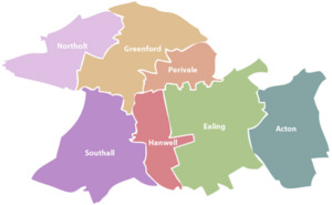
Northolt is a town in West London, England. It's about 18 kilometers (11 miles) west of central London. Northolt is one of the seven main towns in the London Borough of Ealing. A small part of Northolt is also in the London Borough of Harrow. In 2011, about 30,304 people lived here.
Contents
Discovering Northolt's Past
Northolt has a long and interesting history. Its name comes from old English words. Norð healum meant "north nook" or "north retreat" way back in 872. By 1610, the name "Northolt" was commonly used.
Early Settlements and Farming Life
Archaeologists believe Northolt started as a Saxon village around the 8th century. This village was near Northolt Manor. The town is even mentioned in the famous Domesday Book from 1086. Back then, it was called Northala.
In the 1700s, farmers in Northolt started growing hay for London. They also grew crops like peas and beans. Until the late Victorian era, Northolt was mostly a quiet farming area.
How Transport Shaped Northolt
Big changes came with new transport links. In 1801, the Grand Junction Canal (now part of the Grand Union Canal) opened. It passed right through Northolt. This canal helped move goods easily.
Later, railways arrived. The Great Central Railway line opened in 1906. It connected Northolt to places like Marylebone. In 1926, the Northolt Park railway station opened. The Great Western Railway also built a line through Northolt in 1906. This line later became Northolt tube station in 1948, connecting the town to the London Underground Central line.
Northolt During Wartime
During World War I, an airfield was set up nearby in 1915. It was named RAF Northolt because the closest railway station was Northolt Junction. This airfield became very important.
Also during World War I, a large explosives storage site was built in Northolt. It held huge amounts of explosives for making ammunition. After the war, this site was removed.
Growing into a Modern Town
Northolt started to grow into a suburban area in the 1920s. Many homes were built in the 1920s and 1930s. More housing, especially council homes, was built in the 1960s and 1970s.
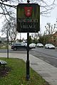
Today, the Grand Union Canal and the A40 road are still important transport links. A new housing area called "Grand Union Village" was built in the 21st century. It even has a new marina for canal boats.
Exploring Northolt's Landmarks
Northolt has several interesting places to visit.
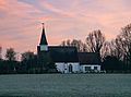
- St Mary the Virgin church is from the 14th century. It stands on a hill overlooking the old village.
- In the village center, there's a clock tower. It was put up in 1937 to celebrate the coronation of King George VI.
- The White Hart public house is on the site of an old coaching inn.
- Willow Cottages on the village green are said to be built from bricks from the old manor house.
- The two towers of a disused RAF radio station are now part of a recreation ground. This area is now a National Air Traffic Control base.
- Northala Fields is a large park next to the A40 road. It has four big, man-made hills built from rubble from the old Wembley Stadium. These hills help block traffic noise. Behind them are new ponds and a visitor center.
- The Larkspur Rovers F.C. clubhouse is in Rowdell Road. It received funding to improve its facilities.
- A village community center on Ealing Road has an open-air miniature railway.
- A new leisure center opened in 2010. It has a pool, a fitness center, a community hall, and a library.
- Down Barns Moated Site is an ancient monument.
Northolt Village Gallery
-
Village sign with Middlesex coat of arms
-
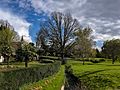
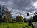
Belvue Park
-
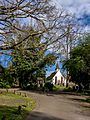
St Mary's Church
-
St Mary's Church
-
-
Signage of The Crown pub


Northolt's Location and Surroundings
Northolt is in the northwest part of Ealing. It borders the boroughs of Harrow and Hillingdon. The center of Northolt is about 40 meters (131 feet) above sea level. It's hillier in the north and lower in the south.
The town is mostly suburban, meaning it has many homes. There's some industrial land near the Grand Union Canal. Northolt also has large green spaces like Lime Tree Park and Rectory Park. Some areas to the west are more rural.
Northolt is close to several other towns:
- Hayes (5.3 km or 3.3 mi)
- Southall (3.9 km or 2.4 mi)
- Greenford (2.3 km or 1.4 mi)
- Wembley (5.0 km or 3.1 mi)
- Harrow (4.3 km or 2.7 mi)
- Ruislip (4.5 km or 2.8 mi)
- Uxbridge (7.2 km or 4.5 mi)
 |
South Ruislip | South Harrow | Sudbury Hill, Harrow on the Hill | |
| Northolt Aerodrome, North Hillingdon | Greenford Green, Perivale | |||
| Yeading | Yeading, | Greenford |
Northolt's Climate
Northolt has a typical climate for London. Here's a look at the average weather:
| Climate data for Northolt (1991–2020) | |||||||||||||
|---|---|---|---|---|---|---|---|---|---|---|---|---|---|
| Month | Jan | Feb | Mar | Apr | May | Jun | Jul | Aug | Sep | Oct | Nov | Dec | Year |
| Mean daily maximum °C (°F) | 8.2 (46.8) |
8.8 (47.8) |
11.6 (52.9) |
14.8 (58.6) |
18.1 (64.6) |
21.2 (70.2) |
23.5 (74.3) |
23.1 (73.6) |
20.0 (68.0) |
15.6 (60.1) |
11.3 (52.3) |
8.6 (47.5) |
15.4 (59.7) |
| Mean daily minimum °C (°F) | 1.9 (35.4) |
2.0 (35.6) |
3.5 (38.3) |
5.2 (41.4) |
8.3 (46.9) |
11.3 (52.3) |
13.4 (56.1) |
13.2 (55.8) |
10.6 (51.1) |
7.9 (46.2) |
4.5 (40.1) |
2.3 (36.1) |
7.0 (44.6) |
| Average rainfall mm (inches) | 62.9 (2.48) |
49.1 (1.93) |
42.4 (1.67) |
45.6 (1.80) |
51.8 (2.04) |
50.2 (1.98) |
48.6 (1.91) |
56.6 (2.23) |
51.4 (2.02) |
70.2 (2.76) |
71.4 (2.81) |
63.1 (2.48) |
663.3 (26.11) |
| Average rainy days (≥ 1 mm) | 11.6 | 10.1 | 9.1 | 9.4 | 8.6 | 8.6 | 8.1 | 9.4 | 8.5 | 10.7 | 11.6 | 11.3 | 117.0 |
| Source: Met Office | |||||||||||||
Northolt's Community and People
Northolt is divided into two main areas for local elections: Northolt Mandeville and Northolt West End.
Types of Homes
Here's a look at the types of homes in Northolt from the 2011 Census:
| Ward | Detached | Semi-detached | Terraced | Flats and apartments |
|---|---|---|---|---|
| Northolt Mandeville | 3.7% | 29.6% | 25.3% | 40.8% |
| Northolt West End | 3.0% | 26.4% | 17.4% | 53.1% |
Population Growth

Northolt's population grew slowly for a long time.
- 1066 – 32 people
- 1801 – 336 people
- 1871 – 479 people
- 1921 – 904 people
Then, in the mid-20th century, the population grew very quickly:
- 1961 – 26,000 people
- 1991 – 32,000 people
This fast growth happened because Northolt became a "dormitory town." This means many people lived here and traveled to work in nearby Ealing. The A40 road also helped the area grow.
Pony Racing History

Northolt was once famous for pony racing! A special racecourse was built in Northolt Park. It opened in 1929.
During World War II, the land was used by the army. It even became a prisoner of war camp. After the war, the land was used to build homes instead of bringing back pony racing. The Racecourse Estate, a large housing area, was built between 1951 and 1955. You can still see the original racecourse gates in Petts Hill. A long, flat stretch of land near Mandeville Road is also part of the old track.
Schools in Northolt
Northolt has many schools for young people.
- Alec Reed Academy
- Belvue High School
- Gifford Primary School
- Greenwood Primary School
- Northolt High School
- Petts Hill Primary School
- St. Raphael's Catholic Primary School
- Downe Manor Primary School
- Viking Primary School
- Willow Tree Primary School
- Wood End Primary School
- Wood End Academy
Getting Around Northolt


Northolt has good transport links.
- Underground: Northolt tube station is on the London Underground Central line.
- Train: Northolt Park railway station is served by Chiltern Railways.
- Buses: Many London Buses routes serve Northolt. These include routes 90, 120, 140, 282, 395, 398, 487, 696, 697, E6, E7, E9, E10, N7, N140, and SL9.
Famous People from Northolt
Several notable people have connections to Northolt:
- Michael Colclough (1944–2016), a church leader at St Paul's Cathedral.
- Alton Ellis (1938–2008), a musician known as the "Godfather of Rocksteady".
- Paul Gardiner (1958–1984), a bass guitar player for the band Tubeway Army.
- Stanley Green (1915–1993), a well-known "human billboard" in London.
- Paul Kidby, an artist famous for his work with author Terry Pratchett's Discworld books, was born here.
- Bassam Mahfouz, a politician, grew up in Northolt.
- Jerome Okimo, a footballer for Stevenage F.C., grew up in Northolt.
- Steve Perryman, a famous footballer for Tottenham Hotspur F.C., grew up in Northolt.
Northolt on Television
Northolt has also been featured on TV:
- The BBC comedy show My Hero (2000–2006) was set in Northolt.
- A TV show called Ghostwatch, broadcast in 1992, was filmed in Northolt. It was a scary story about a haunted house.
