West London facts for kids
West London is the western part of London, England. It's located north of the River Thames and west of the City of London. It stretches all the way to the edge of Greater London.
People use the term "West London" to tell it apart from other areas like Central London, North London, East London, and South London. Historically, West London was part of the old county called Middlesex.
How West London Grew
Early West London started growing in two main spots. One was around a place called Thorney Island, where Westminster Abbey and the Palace of Westminster are now. The other area grew outwards from the walls of the City of London, heading west towards Westminster.
In the 1600s, fancy new buildings connected these two growing areas. This new area became a popular spot itself, later known as the West End of London.
Westminster's Early Start
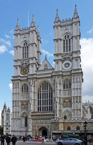
The area began to develop when Westminster Abbey was built on Thorney Island. This spot might have been chosen because an old Roman road, Watling Street, was thought to cross the Thames nearby. Records show the Abbey was founded in the 960s or early 970s. The island and its surroundings became known as Westminster because of the church.
A legend says that in the early 600s, a fisherman named Edric helped a stranger cross the Thames to Thorney Island. This stranger was actually St Peter! He came to bless the new church, which would become Westminster Abbey. St Peter rewarded Edric with lots of fish. Every year on June 29th, the Worshipful Company of Fishmongers gives the Abbey a salmon to remember this event.
The Palace of Westminster also grew in this area. The Parliament has been based there since 1265. Having the government's center so close to the City of London made western London the fastest-growing part of early London.
The First West End Area
The City of London grew much faster outside its western gates (Ludgate and Newgate) than it did to the north or east. This was because the roads from these western gates led straight to Westminster, the political center. A large, busy area outside the city walls, called Farringdon Without, was built up in the 1100s. Some people called this London's First West End.
From the 1400s to the 1600s, growth along the roads from Ludgate (Fleet Street and The Strand) and Newgate (Holborn and High Holborn) sped up. This growth spread far beyond Farringdon Without, into areas like Holborn, Bloomsbury, and Westminster.
A New Fashionable West End
The growth from Westminster and the City of London joined up around the time of Henry VIII. This was also when Westminster first became a city.
In the mid-1600s, Henry Jermyn helped develop the St James's and Mayfair areas of Westminster. These districts became a trendy new focus for western London, known as the West End. Jermyn was even called the Father of the West End.
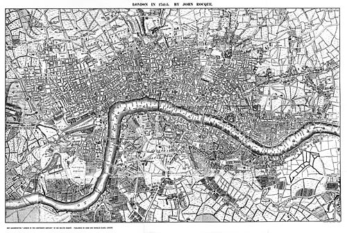
In 1720, a book called "Survey of London" by John Strype described Westminster as one of London's four main areas. He listed the City of London, Westminster (West London), Southwark (South London), and 'That Part beyond the Tower' (East London). The area we now call North London developed later.
Rich people liked living in the West End because it was usually upwind of the smoke from the crowded City. Another reason West London grew quickly was the many bridges connecting it to South London. Even today, there are no bridges east of Tower Bridge, partly because the river gets wider there.
The name "West End of London" became very popular in the 1800s.
Fast Growth with Railways
Like other parts of London, West London grew very fast in the Victorian era. This was thanks to railways, which made it easy for people to travel to work. The building of major train stations like Paddington and Marylebone, and the lines from them, had a huge impact. This trend continued in the 1900s, boosted by cars.
London's size became more stable after the Metropolitan Green Belt was created, which is a protected area of countryside around the city.
West London's Geography
Land and Water Features
West London is an area that isn't perfectly defined. It lies north of the River Thames and stretches west from the edge of the City of London. It includes the historic heart of Westminster and the West End, and goes all the way to the Greater London boundary, which is often marked by the River Colne. Some people also include the boroughs of Brent and Harrow, using the ancient Watling Street as a boundary in those outer areas. The Grand Union Canal is a major waterway within West London.
West London is bordered by other counties: Surrey to the southwest and south, Berkshire to the west and northwest, Buckinghamshire to the northwest, and Hertfordshire to the north.
In 2011, the Mayor of London said that the London boroughs of Brent, Harrow, Ealing, Hammersmith and Fulham, Hounslow, Richmond, and Hillingdon are part of West London. Some parts of West London, like Westminster and the West End, are also considered part of Central London. The London Borough of Richmond upon Thames crosses the River Thames, so its status can be a bit confusing.
The term "West London" helps to divide London into different sections, like North London, East London, and South London.
Official Ways of Defining West London
The term "West London" is used for different official reasons, with its boundaries changing depending on the purpose.
Planning Areas
The London Plan (a plan for how London should develop) changed its "West" sub-region in 2011. This area is used for planning, working with communities, sharing resources, and checking progress. It includes the London Boroughs of Brent, Harrow, Ealing, Hammersmith and Fulham, Hillingdon, Hounslow, and Richmond upon Thames.
This planning area includes outer parts of West London. It also includes parts of the London Borough of Richmond upon Thames that are south of the river, which aren't usually thought of as West London.
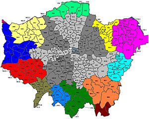
W Postcode Area
The W (Western) postcode area was created in 1857 to help deliver mail. This postcode area covers a smaller part of West London.
West London's Economy
Important Business Areas
The London Plan names two areas in London as "International Centres": the West End and Knightsbridge. Both of these are in West London. Five of the thirteen "Metropolitan Centres" (important town centers) in the plan are also in West London: Ealing, Hounslow, Harrow, Uxbridge, and Shepherd's Bush.
Eleven of the London Plan's "Opportunity Areas" (places set for major development) are part of West London. These include Kensal Canalside, Paddington, Earl's Court and West Kensington, Harrow and Wealdstone, Park Royal, Old Oak Common, Southall, Tottenham Court Road, Victoria, Wembley, and White City.
Major Employers
London Heathrow Airport is a very big employer in West London. The University of West London also has more than 47,000 students, making it a significant part of the area's economy.
 | Shirley Ann Jackson |
 | Garett Morgan |
 | J. Ernest Wilkins Jr. |
 | Elijah McCoy |


