City and Liberty of Westminster facts for kids
The City and Liberty of Westminster was an old way of governing a part of London. It was located in the county of Middlesex, England. This area was right next to the City of London.
At first, Westminster Abbey managed this area. Later, a group called the Westminster Court of Burgesses took over. They were in charge from 1585 until 1900. Today, this historical area is the southern part of the modern City of Westminster in Greater London.
Contents
How Westminster Was Governed
After Westminster Abbey was closed down (this was called the Dissolution of the Monasteries), a new group was set up in 1585. This group was called the Westminster Court of Burgesses. Their job was to govern the Westminster area.
The "City and Liberties of Westminster" were officially defined in 1604. The court of burgesses and the "liberty" (which meant a special area with its own rules) continued to exist. They lasted until 1900, when the Metropolitan Borough of Westminster was created.
Leaders and Rules
The court of burgesses was led by a person called the High Steward of Westminster Abbey. This person was usually an important politician in the country. The High Steward chose a high bailiff. This bailiff served for life and did many jobs similar to a high sheriff in a county.
The city and liberty were split into twelve wards. Each ward had a burgess and an assistant burgess. This system was similar to how the City of London was organized. Eight wards were in the parish of St Margaret. Three were in St Martin in the Fields. One ward covered St Clement Danes and the Strand area.
The burgesses also picked two head burgesses. One was for the city and one for the liberty. These two ranked just below the high bailiff. A high constable was chosen by the court. This constable led a group of constables (police officers). These local constables joined the Metropolitan Police in 1829.
When the court of burgesses ended in 1900, a special link was kept. The Lord Mayor of Westminster now acts as the Deputy High Steward of Westminster Abbey.
Westminster also had the right to send two members to parliament. People living in the Liberty of the Savoy could also vote with Westminster. This included parts of St Clement Danes and St Mary le Strand parishes.
Westminster had its own coroner's district until 1930. A coroner investigates deaths that are sudden or unusual. After 1930, it became part of a larger district in London.
Areas That Made Up Westminster
The City of Westminster included:
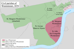
- The main part of the parish of St Margaret. After 1727, this became the combined parishes of St Margaret and St John.
- The special area around Westminster Abbey, called the Close of the Collegiate Church of St Peter.
The Liberty of the City of Westminster included:
- A separate part of the parish of St Margaret.
- The parish of St Martin in the Fields. This parish was later divided into smaller parishes like St Anne (in 1687), St George Hanover Square (in 1724), St Paul Covent Garden (in 1645), and St James (in 1685).
- Part of the parish of St Clement Danes.
- Part of the parish of St Mary-le-Strand.
- The special area of St James's Palace.
- Privy Gardens (also known as Whitehall Gardens).
- The area around the Palaces of St James and Whitehall (also known as Whitehall).
Westminster's Location
In 1843, a book called the Penny Cyclopaedia described Westminster's borders. It said the southern and eastern sides were along the River Thames. The border left the river between Waterloo Bridge and Hungerford Market. It then followed the Strand eastward to Temple Bar. This part was separated from the river by the liberty of the duchy of Lancaster and the western part of the Temple.
The border then turned north from Temple Bar up Shire Lane. It then ran westward in a zig-zag line, staying south of Lincoln’s Inn Fields until it reached Drury Lane. It then turned north-west up Drury Lane to Castle Street. It turned westward again, then northward, running by Castle Street, West Street, and Crown Street, Soho. This led to the eastern end of Oxford Street.
The northern border ran straight westward along Oxford Street. It continued along the north side of Hyde Park and Kensington Gardens. It made a small detour to include St. George’s burying-ground. It then went to the northern end of the Serpentine river.
From this point, the western border followed the Serpentine river. It then followed a stream that ran from its south-eastern end. This stream is now mostly covered over. It ran west of Kinnerton Street, Lowndes Street, Chesham Street, Westbourn Street, and the Commercial Road. Finally, it reached the Thames just in front of Chelsea Hospital.
 | DeHart Hubbard |
 | Wilma Rudolph |
 | Jesse Owens |
 | Jackie Joyner-Kersee |
 | Major Taylor |


