
Liberty of the Savoy facts for kids
| The Savoy Liberty of the Duchy of Lancaster |
|
 |
|
| Geography | |
| Status | Manor, Liberty |
| HQ | Somerset House |
| History | |
| Created | 1246 |
Quick facts for kids Politics |
|
|---|---|
| Governance | Court Leet of the Savoy |
| Subdivisions | |
| Type | Wards (4) |
| Units | Church, Middle, Royal, Savoy |
The Savoy was a special area in England. It was known as a manor and a liberty. This meant it had its own rules, separate from the king's direct control.
The Savoy was located in the county of Middlesex. It was found between the Liberty of Westminster, the City of London, and the River Thames.
This entire area belonged to the Duchy of Lancaster. Because of this, it was also called the Liberty of the Duchy of Lancaster. The Duchy of Lancaster still owns land in this area today. The Savoy included the area around the old Savoy Palace. It also covered parts of the parishes of St Clement Danes and St Mary le Strand.
Contents
History of The Savoy
Where Did the Name "Savoy" Come From?
The name "Savoy" comes from Peter II, Count of Savoy. He was given this land by King Henry III in 1246. Peter was the uncle of Queen Eleanor of Provence.
The Palace and Hospital
King Henry III gave the land for the famous Savoy Palace to Peter of Savoy. Peter later gave the palace to a group of monks. They turned it into a hospital called "The Great Hospital of St Bernard de Monte Jovis in Savoy."
Later, Queen Eleanor bought the hospital. She then gave the land to her second son, Edmund, Earl of Lancaster. When Edward I became king, he officially confirmed that Edmund owned the Savoy area.
The Duchy's Special Liberty
In 1351, Henry of Grosmont became the first Duke of Lancaster. He was a great-grandson of King Henry III. He earned this title for his help in the Hundred Years War.
The main home of the Duchy of Lancaster was in Lancashire. This area became a county palatine. This meant it was ruled by powerful noblemen. They had special authority and were quite independent from the rest of the Kingdom of England. Even though they were loyal to the king, they could rule their county and its lands almost on their own.
All other lands connected to the Duchy of Lancaster, including the Savoy, also followed the duke's laws. This was very important! For example, if someone owed money in London, they could hide in the Savoy. People working for the king could not arrest them there. Royal orders from the king were not valid in Lancashire until the 1800s. The Duchy even had its own special court until the 1970s. These unique rules have been used in many historical adventure books.
How The Savoy Was Governed
The Savoy was a part of the Duchy of Lancaster. It was divided into four smaller areas called wards. These were named Church, Middle, Royal, and Savoy. A special local court, called a court leet, managed the area.
Even though it had its own rules, the Liberty of the Savoy was part of Middlesex. People living there who could vote in elections voted for the Westminster representatives in Parliament.
The Liberty of the Savoy also had its own coroner until 1930. A coroner investigates deaths that are sudden or unusual. After 1930, it became part of a larger district in London.
A tradition called "beating the bounds" was stopped by the Duchy of Lancaster in 1969. This tradition involved walking around the borders of the area to mark them. It was brought back in 2010. The Duchy of Lancaster still owns land within the Savoy area today.
Geography of The Savoy
The River Thames formed the southern border of the Savoy. Most of the area was south of a main road called the Strand. The Savoy was made up of parts of two church parishes and one extra-parochial place. These areas included:
- A rectangular part of the St Clement Danes parish. This area is now home to the famous Savoy Hotel.
- All of the Precinct of the Savoy. This is where you can find the Savoy Chapel and Savoy Street.
- A small part of the St Clement Danes parish north of the Strand.
- About three-quarters of the St Mary le Strand parish. This area is now mostly taken up by Somerset House.
- About half of the main part of the St Clement Danes parish, south of the Strand.
Special markers show where the borders of the Savoy used to be.
Images for kids
-
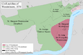
A map from 1870 showing the Westminster Civil Parish, which includes the area of The Savoy.
