Westminster St Margaret and St John facts for kids
| St Margaret and St John St Margaret (until 1727) Westminster District (1855–1887) |
|
 |
|
| Geography | |
| Status | District (1855–1887) |
| 1881 area | 815 acres (3.30 km2) |
| 1901 area | 766 acres (3.10 km2) |
| 1921 area | 767 acres (3.10 km2) |
| HQ | Town Hall, Caxton Street |
| History | |
| Origin | Ancient parish |
| Created | 10th century |
| Abolished | 1922 |
| Succeeded by | City of Westminster (parish) |
Quick facts for kids Demography |
|
|---|---|
| 1881 population - 1881 density |
59,926 73.53/acre |
| 1901 population - 1901 density |
51,068 66.67/acre |
| 1921 population - 1921 density |
39,916 52.04/acre |
| Politics | |
| Governance | St Margaret Vestry (16th century–1727) St Margaret and St John Vestry (1727–1855) Westminster District Board of Works (1855–1887) St Margaret and St John Combined Vestry (1887–1900) |
 |
|
| Subdivisions | |
| Type | Parishes (after 1727) |
| Units | St John St Margaret |
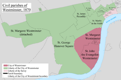
St Margaret was an old area in Westminster, England. It was part of the county of Middlesex. This area included the main part of what we now call Westminster. It had famous places like the Palace of Westminster, but not Westminster Abbey itself.
In 1727, the area was split into two parts: St Margaret's and St John's. This happened when the Church of St John the Evangelist was built in Smith Square. The church was needed because more people were moving into the area. Even after the split, both parts were managed by one group called the St Margaret and St John Vestry.
Later, in 1855, this group changed. The two areas then formed the Westminster District until 1887. In 1889, St Margaret and St John became part of the County of London. The vestry was replaced by the Westminster City Council in 1900. St Margaret and St John officially stopped existing as a separate area in 1922.
Contents
How the Area Was Governed
St Margaret was an ancient parish, which means it was a very old local area. It was managed by a group called a vestry. This vestry was like a local council that looked after the area's needs. Before 1542, St Margaret's also included land near the church of St Clement Danes. This land later became part of the St Martin in the Fields area.
In the 1700s, a special group was set up to build new churches in busy parts of London. The Church of St John the Evangelist was finished in 1728. To go along with this new church, a new area called St John the Evangelist was created in 1727. This new area was separated from St Margaret for both church and local government purposes.
Even though they were split, St Margaret and St John continued to be managed by one combined vestry. People often called them Westminster St Margaret and St John.
In 1855, the two areas became part of the Westminster District. This was when they came under the control of the Metropolitan Board of Works, a larger body that managed public works in London. St Margaret chose 30 people to be on the district board, and St John chose 27.
Because both St Margaret and St John had more than 2,000 people who paid local taxes, they were divided into smaller sections called wards. Each ward elected people to the vestry. For example, St Margaret had three wards, and St John also had three wards.
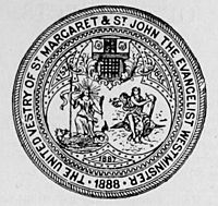
In 1887, the local authority changed its name to the St Margaret and St John Combined Vestry.
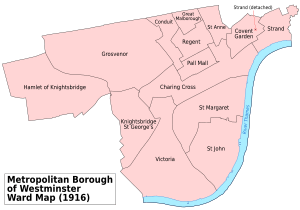
By 1889, these areas became part of the County of London. The combined areas tried to become a municipal borough in 1897 but were not successful. In 1900, they became part of the Metropolitan Borough of Westminster. St Margaret and St John officially ended as a civil parish in 1922.
Public Libraries
The St Margaret vestry was the first local council in London to use the Public Libraries Act 1855. This law allowed local areas to set up public libraries. In 1856, they held a public meeting. Enough people voted to create a library, and a librarian was hired that same year. The Westminster Public Library on Great Smith Street opened in 1857. A year later, in 1858, another library opened in Trevor Square, Knightsbridge.
Geography of the Area
The main part of the St Margaret area was next to the River Thames on its eastern side. St Margaret's was located north of St John's. The St Margaret area also had a separate piece of land to its west. This detached part was similar in size and was known as Kensington Gore. It included parts of what are now Knightsbridge and Kensington Palace.
In older times, when monasteries and royal palaces were very important, there were a few special areas within St Margaret's that were not part of the parish itself. These included:
- The area around Westminster Abbey, which was considered its own special place.
- Privy Gardens (recorded in 1831).
- The area around the Palaces of St James and Whitehall (recorded in 1841).
- Whitehall (recorded in 1831).
Population Changes Over Time
The number of people living in Westminster St Margaret and St John changed a lot over the years. Like many central London areas, the population grew until the 1800s. Then, as transportation improved and people could live further away, the population started to decrease. Many people moved to the suburbs. The highest population was recorded in 1871.
| Year | 1801 | 1811 | 1821 | 1831 | 1841 | 1851 | 1871 | 1881 | 1891 | 1901 | 1911 | 1921 |
|---|---|---|---|---|---|---|---|---|---|---|---|---|
| Population | 17,508 | 19,202 | 22,568 | 25,529 | 30,489 | 31,314 | 66,050 | 59,926 | 55,539 | 51,068 | 47,692 | 39,916 |
 | Laphonza Butler |
 | Daisy Bates |
 | Elizabeth Piper Ensley |


