St George Hanover Square facts for kids
| St George Hanover Square | |
 |
|
 |
|
| Geography | |
| Status | Civil parish (1724–1922) Poor law parish (1834–1870) |
| 1851 area | 1,161 acres (4.70 km2) |
| 1901 area | 1,111 acres (4.50 km2) |
| 1921 area | 1,110 acres (4.5 km2) |
| HQ | Vestry Hall, Mount Street, Mayfair |
| History | |
| Origin | Commission for Building Fifty New Churches |
| Created | 1724 |
| Abolished | 1922 |
| Succeeded by | City of Westminster (parish) |
Quick facts for kids Demography |
|
|---|---|
| 1851 population - 1851 density |
73,230 63.1/acre |
| 1901 population - 1901 density |
76,957 69.3/acre |
| 1921 population - 1921 density |
67,280 60.6/acre |
| Politics | |
| Governance | St George Hanover Square Vestry (1724–1900) |
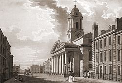
St George Hanover Square was a special area in Westminster, England. It was called a civil parish. This area was created in 1724. It happened when the Church of St George's, Hanover Square was built. More people were moving to the area, so a new parish was needed.
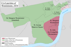
The parish was formed from part of an older area called St Martin in the Fields. It was in Middlesex, which is now part of Greater London. St George Hanover Square included very fancy parts of West End. These areas included Belgravia and Mayfair.
A group called a select vestry managed the parish. This group was mostly made up of rich and noble people. But new laws changed how the vestry worked. In 1889, the parish became part of the County of London. The vestry was replaced by Westminster City Council in 1900. The parish officially ended in 1922.
Contents
How the Parish Started
In 1710, a law called the New Churches in London and Westminster Act was passed. This law created a group called the Commission for Building Fifty New Churches. Their job was to build new churches. They also decided where the new parish boundaries would be. They chose people to run the new parishes.
St George Hanover Square included some of the most stylish parts of London. Many rich families lived there. The select vestry had 100 men. Many people in the parish only lived there for part of the year. This was often during the social season. The parish was created in 1724. It was part of the older St Martin in the Fields area.
Where the Parish Was Located
The northern border of the parish was Bayswater Road and Oxford Street. This stretched from Lancaster Gate to Oxford Circus. The western border was the River Westbourne. The southern border was the River Thames.
The parish included part of Hyde Park. This was the area northeast of the Serpentine lake. It also covered the Mayfair area. Further south, it became narrower. This southern part included Belgravia, Knightsbridge, Victoria Station, and Pimlico. Hanover Square was close to the northeastern border. The grounds of Buckingham Palace were inside the parish. However, the palace itself was in the St Martin in the Fields parish.
Changes and Reforms
The parish adopted a new law in 1831 called the Vestries Act 1831. This law allowed all ratepayers to vote for vestry members. Ratepayers were people who paid local taxes. This change meant that rich and noble people had less control over the vestry. In 1815, 40% of the vestry members had titles. By 1845, this number was cut in half.
In 1855, the parish vestry became a local government body. It worked under the Metropolitan Board of Works. This board was in charge of public works in London.
The Metropolis Management Act 1855 said that large parishes should be divided into wards. St George Hanover Square was already divided into seven wards in 1827. These wards were Dover, Conduit, Grosvenor, Brook, Curzon, Knightsbridge, and The Out. Each ward had a certain number of vestry members.
Church Divisions
At first, St George Hanover Square was one parish for both church and local government. But by 1865, it was divided into eleven smaller church areas. These were called ecclesiastical districts.
Helping the Poor
St George Hanover Square had its own system for helping the poor. It did not join the new national system. This was set up by the Poor Law Amendment Act 1834. So, the parish vestry kept control of poor relief. They did not have a separate group called a board of guardians.
Later, in 1870, St George joined with another parish, St Margaret and St John. They formed the St George's Union. A board of guardians was then elected to manage poor relief for this union.
End of the Parish
In 1889, the parish became part of the new County of London. The vestry, which ran the parish, was officially ended in 1900. Its duties were taken over by Westminster City Council. This happened when it became part of the Metropolitan Borough of Westminster. The parish officially stopped existing as a civil parish in 1922.
Population Over Time
The number of people living in St George Hanover Square changed over the years. Here's how the population looked:
| Year | 1801 | 1811 | 1821 | 1831 | 1841 | 1851 | 1871 | 1881 | 1891 | 1901 | 1911 | 1921 |
|---|---|---|---|---|---|---|---|---|---|---|---|---|
| Population | 38,440 | 41,687 | 46,384 | 58,209 | 66,552 | 73,230 | 90,028 | 89,573 | 78,364 | 76,957 | 70,106 | 67,280 |
Notable People
- Lady Amabel Kerr (1846-1906), a writer.
 | Janet Taylor Pickett |
 | Synthia Saint James |
 | Howardena Pindell |
 | Faith Ringgold |

