
River Westbourne facts for kids
The Westbourne or Kilburn is a river in London that mostly flows underground in large pipes. It starts in areas like Hampstead and Brondesbury Park. From there, it travels south through Kilburn and Bayswater (which is part of Paddington).
The river then goes under the eastern side of Hyde Park's Serpentine lake and continues through central Chelsea, even passing under Sloane Square. It eventually flows into London's large combined sewer system. This means it mixes with wastewater from homes and businesses. In the past, the Westbourne was a clean river, but over time, as London grew, it became a sewer.
Contents
What's in a Name?
This river has had many names over the years! It was first called the Kilburn, which means "royal stream." The word "bourne" or "burn" is an old word for a small river.
Some of its other names include:
- Kelebourne
- Bayswater River
- Serpentine River
- The Bourne
- Westburn Brook
- Ranelagh River
- Ranelagh Sewer
It's similar in size to another famous lost London river, the Fleet.
Where the River Flows
The Westbourne starts from several small sources in Hampstead and Brondesbury Park. It then flows south through Kilburn. For a while, it runs west along Kilburn Park Road and then south along Shirland Road.
After crossing Bishops Bridge Road, the river continues south. This part of the river was known as the Bayswater rivulet until the early 1800s. This is how the area now called Bayswater got its name! "Bayards Watering" was mentioned as early as 1380, likely a place where a man named Bayard watered horses.
The Serpentine Lake
The river enters Hyde Park where the Serpentine lake is today. Another small stream, Tyburn Brook, joins it here.
The Serpentine lake was created in 1730. Queen Caroline, the wife of King George II, wanted to make the royal park more beautiful, so a dam was built across the Westbourne.
However, the Westbourne stopped supplying water to the Serpentine in 1834. By then, the river had become a main sewer for the growing city. Today, the Serpentine gets its water from deep underground boreholes in Hyde Park. Many other parks and gardens copied the design of the Serpentine.
Knightsbridge and Chelsea
The Westbourne left Hyde Park at a place called Knightsbridge. This name originally came from a bridge over the Westbourne itself! Records show that in 1141, the people of London met Queen Matilda at this bridge.
From Knightsbridge, the river flows south under Bourne Street. It follows the border between the City of Westminster and the Royal Borough of Kensington and Chelsea very closely. Finally, it joins the River Thames in Chelsea.
From Drinking Water to Sewer
In the past, the water of the Westbourne was very clean. In the 1400s, pipes were even laid to carry its water into the City of London for people to drink!
But in the 1800s, as more people moved to London and water closets (toilets) became common, the river became very dirty. It was used as a sewer.
As areas like west Belgravia, east Chelsea, and Paddington were built up, it became clear the river would have to remain a "combined sewer." This means it carries both rainwater and wastewater. Large pipes were built in the early 1800s and 1850s to handle this. The Westbourne is now known as one of London's "lost rivers" because it flows mostly underground.
The Pipe at Sloane Square Station
You can still see a part of the Westbourne's pipe today! It runs above the platforms of Sloane Square tube station. This pipe, made in the 1800s from riveted metal sections, is visible near the ceiling at the end of the platforms closest to the exits.
Even when the station was badly bombed during the Bombing of London in November 1940, this pipe was not damaged!
Joining the Main Sewer System
After flowing under parts of the Royal Military Hospital Gardens and Chelsea Barracks, the Westbourne's drain was designed to flow into the Northern Low Level Sewer. This sewer system was designed by Joseph Bazalgette.
To help the sewer system cope with all the water, especially during heavy storms, a new tunnel called the Thames Tideway Scheme is being built. This will help prevent dirty water from overflowing into the River Thames.
The Westbourne's emergency overflow into the tideway (the part of the Thames affected by tides) is about 300 yards west of Chelsea Bridge. This overflow, also called the Ranelagh Sewer, is usually visible except at high tide. The goal is for the Westbourne's flow to be caught by two main sewers: the Middle Level Sewer and the Northern Low Level Sewer, which are part of the London sewerage system.
Images for kids
-
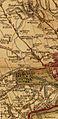
Route of the River Westbourne (highlighted in blue) shown between West End (now known as West Hampstead) and the Thames on a map from 1790.
-
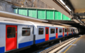
The River Westbourne running above the platforms of Sloane Square tube station. The drain is inside the green conduit above the train.


See also
 In Spanish: Río Westbourne para niños
