St Anne Within the Liberty of Westminster facts for kids
| St Anne | |
 |
|
| Geography | |
| Status | Civil parish (1687–1922) |
| 1881 area | 54 acres (0.22 km2) |
| HQ | Vestry Hall, Dean Street, Soho |
| History | |
| Created | 1687 |
| Abolished | 1922 |
| Succeeded by | City of Westminster (parish) |
Quick facts for kids Demography |
|
|---|---|
| 1881 population | 16,608 |
| 1901 population | 11,493 |
| 1921 population | 6,699 |
| Politics | |
| Governance | St Anne Vestry (1687–1900) |
St Anne Within the Liberty of Westminster, often called St Anne Soho, was a special local area in England. It was like a small district that managed its own local services. This area was first part of the county of Middlesex. Later, it became a part of the new County of London.
This local area was created in 1687. It was formed from a section of a much older area called St Martin in the Fields. St Anne Soho included parts of what we now know as Soho and Chinatown in London. The area was created because more and more people were moving there. A new church, St Anne's Church, Soho, was also built to serve the growing community.
At first, a small group of people managed the area. Over time, more people from the community got to have a say. Later, a larger city group took over some of its duties. In 1889, St Anne Soho became part of the County of London. By 1900, the local government for the area became the Westminster City Council. St Anne Soho continued to exist as a separate local area until 1922.
Contents
How It Started
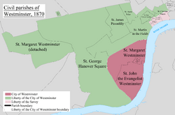
The St Anne Soho area was officially created in 1687. It was carved out of a larger, older area called St Martin in the Fields. This new area was located within the Liberty of Westminster. To create this new area and build its church, a special law was needed. This law was approved by the King on July 15, 1678.
Another law was needed to get money for building the church. A group of local people was put in charge of this. Once the church was finished, this group became like the local council for the area. They were called a "select vestry," meaning a small, chosen group. However, this way of governing was challenged. By May 21, 1744, the area was run by an "open vestry." This meant all local residents could take part in decisions.
Changes Over Time
In 1855, St Anne Soho became part of a larger group of areas called the Strand District. This meant it was also under the control of the Metropolitan Board of Works. This board was responsible for big projects across London. St Anne Soho was a bit separate from the main part of the Strand District. Even so, it sent twenty-four local representatives to the Strand District Board.
In 1889, the area officially became part of the new County of London. Then, in 1900, it joined the Metropolitan Borough of Westminster. St Anne Soho stopped being a separate local area in 1922.
Where Was It Located?
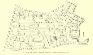
The St Anne Soho area had clear boundaries. To the north, it reached Oxford Street. The western edge was along Berwick Street and Rupert Street. To the south, its border was a bit uneven, going around Leicester Square. The eastern boundary was just west of Charing Cross Road in the north. Further south, it went east of Charing Cross Road.
Today, this area covers the eastern part of Soho. It also includes the vibrant area known as Chinatown.
Helping Those in Need
After new laws were made to help people who were struggling, St Anne Soho joined a group called the Strand poor law union. This union worked together to provide support from 1836 to 1868. Later, it became part of the Westminster union from 1868 to 1913. Finally, it joined the City of Westminster union from 1913. When the St Anne area was officially closed in 1922, it combined with other areas. They formed the City of Westminster area for helping those in need.
How Many People Lived There?
The table below shows how the number of people living in St Anne Soho changed over the years. This information comes from official population counts called censuses.
| Year | 1801 | 1811 | 1821 | 1831 | 1841 | 1851 | 1861 | 1871 | 1881 | 1891 | 1901 | 1911 | 1921 |
|---|---|---|---|---|---|---|---|---|---|---|---|---|---|
| Population | 11,637 | 12,288 | 15,215 | 15,600 | 16,480 | 17,335 | 17,426 | 17,562 | 16,608 | 12,317 | 11,493 | 9,286 | 6,699 |
 | Isaac Myers |
 | D. Hamilton Jackson |
 | A. Philip Randolph |


