Oxford Street facts for kids

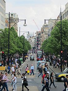
View east along Oxford Street in May 2016
|
|
| Former name(s) | Via Trinobantina Tyburn Road |
| Maintained by | Transport for London |
| Length | 1.2 mi (1.9 km) |
| Location | London, United Kingdom |
| Postal code | W1 |
| Nearest Tube station |
|
| Coordinates | 51°30′55″N 0°08′31″W / 51.515312°N 0.142025°W |
| West end | Marble Arch |
| East end | Tottenham Court Road / Charing Cross Road |
| Other | |
| Known for |
|

Oxford Street is a super famous road in the heart of London, England. It's known all over the world as one of the busiest and best shopping streets! Imagine a street with about 300 shops – that's Oxford Street for you. It's a huge magnet for shoppers from everywhere.
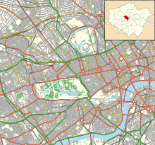
This street is located in the City of Westminster, which is a part of London. It stretches for about 1.2 miles (1.9 kilometers) and is a really important part of London's West End area.
| Top - 0-9 A B C D E F G H I J K L M N O P Q R S T U V W X Y Z |
What is Oxford Street?
Oxford Street is a major road in Central London. It's not just any road; it's considered Europe's busiest shopping street! This means millions of people visit it every year to shop, eat, and enjoy the lively atmosphere.
Part of a Bigger Road
Oxford Street is actually part of a much longer road called the A40 road. This road connects London all the way to the city of Oxford. However, in central London, you won't see signs with "A40" on them. This is because it's mostly used by local traffic and shoppers, not for long-distance journeys.
Shopping Paradise
With around 300 shops, Oxford Street has something for everyone. You can find big department stores like Selfridges, John Lewis & Partners, and House of Fraser. There are also many smaller shops selling clothes, electronics, and souvenirs. It's a great place to find gifts or just browse for hours.
Oxford Circus
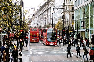
Roughly halfway along Oxford Street, you'll find a very busy intersection called Oxford Circus. This is where Oxford Street crosses another famous road, Regent Street. It's a really popular spot, especially for people using the Tube.
The Diagonal Crossing
In 2009, something special happened at Oxford Circus. A new type of diagonal crossing was opened. This means that pedestrians (people walking) can cross the intersection in all directions, even diagonally, at the same time. It's like a giant "X" for walkers! This makes it much easier and safer for the huge crowds of people who visit. It's currently the only one of its kind in central London.
Getting Around Oxford Street
Oxford Street is very easy to reach using London's underground train system, known as the Tube. There are several Tube stations right on Oxford Street, making it super convenient for visitors.
- Marble Arch
- Bond Street
- Oxford Circus
- Tottenham Court Road
These stations connect you to different Tube lines, so you can get to Oxford Street from almost anywhere in London.
Famous Places on Oxford Street
Oxford Street isn't just about shops. It also has some famous landmarks and places.
- Marble Arch: This historic arch stands at the western end of Oxford Street. It's a well-known landmark and a popular meeting point.
- Selfridges: One of the most famous department stores in the world, Selfridges is known for its beautiful architecture and amazing window displays, especially around Christmas.
- 100 Club: This is a famous music venue located in the basement of a building on Oxford Street. It has been a place for live music since 1942 and has hosted many legendary bands, including those from the trad jazz and punk music scenes.
- HMV: This well-known music and entertainment store chain was founded on Oxford Street in 1921. There's even a blue plaque at No. 363 Oxford Street to remember this important event.
Christmas Lights
Every year, Oxford Street becomes even more magical during the Christmas season. The street is decorated with incredible Christmas lights that attract huge crowds. People come from all over to see the sparkling displays and enjoy the festive atmosphere. It's a truly special time to visit.
Images for kids
-
A view of Oxford Street in 1987, with Selfridges on the right
-
A blue plaque at No. 363 Oxford Street commemorating the founding of HMV in 1921
-
The 100 Club has been a live music venue in the basement of No. 100 Oxford Street since 1942, and has been an important venue for trad jazz and punk bands.
See also
 In Spanish: Oxford Street para niños
 | Toni Morrison |
 | Barack Obama |
 | Martin Luther King Jr. |
 | Ralph Bunche |


