
London Borough of Hillingdon facts for kids
Quick facts for kids
London Borough of Hillingdon
|
|||
|---|---|---|---|
|
|||
| Motto(s):
Forward
|
|||

Hillingdon shown within Greater London
|
|||
| Sovereign state | United Kingdom | ||
| Constituent country | England | ||
| Region | London | ||
| Ceremonial county | Greater London | ||
| Created | 1 April 1965 | ||
| Admin HQ | Hillingdon Civic Centre, Uxbridge |
||
| Government | |||
| • Type | London borough council | ||
| • Body | Hillingdon London Borough Council | ||
| Area | |||
| • Total | 44.67 sq mi (115.70 km2) | ||
| Area rank | 203rd (of 326) | ||
| Population
(2020)
|
|||
| • Total | 306,870 | ||
| • Rank | 40th (of 326) | ||
| • Density | 6,869.4/sq mi (2,652.29/km2) | ||
| Time zone | UTC (GMT) | ||
| • Summer (DST) | UTC+1 (BST) | ||
| Postcodes |
HA, TW, UB, WD
|
||
| Area codes | 01895, 01923, 020 | ||
| ONS code | 00AS | ||
| GSS code | E09000017 | ||
| Police | Metropolitan Police | ||

The London Borough of Hillingdon is a part of Greater London, England. It is located in the western part of London. It is also the westernmost London borough. Hillingdon was created in 1965. It was formed by joining four smaller areas: Hayes and Harlington, Ruislip-Northwood, Uxbridge, and Yiewsley and West Drayton.
This borough is home to most of Heathrow Airport and Brunel University. It is the second largest of the 32 London boroughs in terms of size. The main towns in Hillingdon are Hayes, Ruislip, Northwood, West Drayton and Uxbridge. Hillingdon is one of the least crowded London boroughs. This is because it has a lot of countryside in the north, plus RAF Northolt Aerodrome and Heathrow Airport.
Contents
History of Hillingdon
Hillingdon became a borough in 1965. This happened because of a law called the London Government Act 1963. It brought together the areas of Uxbridge, Hayes and Harlington, Ruislip-Northwood, and Yiewsley and West Drayton.
Before 1965, this area was part of Middlesex. It then became one of the 32 new London Boroughs. The local councils couldn't agree on a name at first. A person named Keith Joseph suggested "Uxbridge" in 1963, but they later changed it to Hillingdon.
How Hillingdon is Governed

The local government for Hillingdon is called Hillingdon Council. Their main office is at Hillingdon Civic Centre in Uxbridge.
The borough is split into 21 smaller areas called wards. People living in these wards vote for their local councillors.
- Belmore
- Charville
- Colham and Cowley
- Eastcote
- Harefield Village
- Hayes Town
- Heathrow Villages (including Harmondsworth, Sipson and Harlington)
- Hillingdon East
- Hillingdon West
- Ickenham and South Harefield
- Northwood
- Northwood Hills
- Pinkwell
- Ruislip
- Ruislip Manor
- South Ruislip
- Uxbridge
- West Drayton
- Wood End
- Yeading
- Yiewsley
Hillingdon's Role in Greater London
Since 2000, Hillingdon has been part of the Ealing and Hillingdon area for elections to the London Assembly. The London Assembly helps to check the work of the Mayor of London.
Onkar Sahota from the Labour Party has been the London Assembly member for Ealing and Hillingdon since 2012. In the 2012 election, Boris Johnson (from the Conservative Party) got the most votes in Hillingdon. He was then elected as the Mayor of London for a second time.
People in Hillingdon

Population Changes
Between 2001 and 2011, the number of people living in Hillingdon grew by 11.5%. This was faster than the average growth for England and Wales. The number of homes also increased, and on average, there were 2.7 people living in each home.
| Population | ||
|---|---|---|
| Year | Pop. | ±% |
| 1801 | 9,232 | — |
| 1811 | 11,033 | +19.5% |
| 1821 | 12,788 | +15.9% |
| 1831 | 14,484 | +13.3% |
| 1841 | 18,329 | +26.5% |
| 1851 | 18,744 | +2.3% |
| 1861 | 20,672 | +10.3% |
| 1871 | 22,600 | +9.3% |
| 1881 | 24,528 | +8.5% |
| 1891 | 26,640 | +8.6% |
| 1901 | 32,548 | +22.2% |
| 1911 | 39,768 | +22.2% |
| 1921 | 58,681 | +47.6% |
| 1931 | 86,613 | +47.6% |
| 1941 | 137,278 | +58.5% |
| 1951 | 217,616 | +58.5% |
| 1961 | 226,074 | +3.9% |
| 1971 | 234,867 | +3.9% |
| 1981 | 226,256 | −3.7% |
| 1991 | 236,720 | +4.6% |
| 2001 | 242,435 | +2.4% |
| 2011 | 273,936 | +13.0% |
| Source: A Vision of Britain through time, citing Census population | ||
Different Backgrounds
In the 2021 census, about 37.1% of people in Hillingdon said they were White British. In the south-east part of the borough, especially in Hayes, there are many residents from South Asia.
The areas with the most people from Black, Asian, and other minority ethnic groups are:
- Barnhill (part of eastern Hayes)
- Pinkwell (around the railway station in southern Hayes)
- Townfield (part of eastern Hayes)
- Yeading (eastern Hayes)
Overall, White people make up 48.2% of the borough's population. Asian residents are 33.3%, and Black residents are 7.8%. The most common language spoken is English (77.9%). Other common languages include Punjabi (4.7%), Polish (1.7%), Tamil (1.6%), and Urdu (1.1%).
| Ethnic Group | Year | |||||||||||
|---|---|---|---|---|---|---|---|---|---|---|---|---|
| 1971 estimations | 1981 estimations | 1991 census | 2001 census | 2011 census | 2021 census | |||||||
| Number | % | Number | % | Number | % | Number | % | Number | % | Number | % | |
| White: Total | – | 97.6% | 207,868 | 93.4% | 203,149 | 87.7% | 192,120 | 79.1% | 166,031 | 60.4% | 147,387 | 48.2% |
| White: British | – | – | – | – | – | – | 176,244 | 72.5% | 142,916 | 52.1% | 113,377 | 37.1% |
| White: Irish | – | – | – | – | – | – | 6,911 | 2.8% | 5,949 | 2.1% | 5,585 | 1.8% |
| White: Gypsy or Irish Traveller | – | – | – | – | – | – | – | – | 344 | 0.1% | 479 | 0.2% |
| White: Roma | – | – | – | – | – | – | – | – | – | – | 691 | 0.2% |
| White: Other | – | – | – | – | – | – | 8,965 | 3.7% | 16,822 | 6.1% | 27,255 | 8.9% |
| Asian or Asian British: Total | – | – | – | – | 22,061 | 9.5% | 33,048 | 13.6% | 69,253 | 25.0% | 101,938 | 33.3% |
| Asian or Asian British: Indian | – | – | – | – | 15445 | 6.7% | 23,234 | 9.6% | 36,795 | 13.4% | 57,341 | 18.7% |
| Asian or Asian British: Pakistani | – | – | – | – | 2008 | 0.9% | 3,816 | 1.6% | 9,200 | 3.3% | 14,243 | 4.7% |
| Asian or Asian British: Bangladeshi | – | – | – | – | 928 | 0.4% | 1,459 | 0.6% | 2,639 | 0.9% | 4,050 | 1.3% |
| Asian or Asian British: Chinese | – | – | – | – | 1185 | 0.5% | 1,883 | 0.8% | 2,889 | 1.0% | 3,184 | 1.0% |
| Asian or Asian British: Other Asian | – | – | – | – | 2495 | 1.1% | 4,539 | 1.9% | 17,730 | 6.4% | 23,120 | 7.6% |
| Black or Black British: Total | – | – | – | – | 3,810 | 1.6% | 8,006 | 3.3% | 20,082 | 7.2% | 23,955 | 7.9% |
| Black or Black British: African | – | – | – | – | 852 | 0.4% | 4,227 | 1.7% | 11,275 | 4.1% | 15,844 | 5.2% |
| Black or Black British: Caribbean | – | – | – | – | 2128 | 0.9% | 3,275 | 1.3% | 4,615 | 1.6% | 5,752 | 1.9% |
| Black or Black British: Other Black | – | – | – | – | 830 | 0.4% | 504 | 0.2% | 4,192 | 1.5% | 2,359 | 0.8% |
| Mixed or British Mixed: Total | – | – | – | – | – | – | 5,588 | 2.3% | 10,479 | 3.7% | 13,359, | 4.3% |
| Mixed: White and Black Caribbean | – | – | – | – | – | – | 1,427 | 0.6% | 2,719 | 0.9% | 3,151 | 1.0% |
| Mixed: White and Black African | – | – | – | – | – | – | 694 | 0.3% | 1,409 | 0.5% | 1,897 | 0.6% |
| Mixed: White and Asian | – | – | – | – | – | – | 1,983 | 0.8% | 3,602 | 1.3% | 4,201 | 1.4% |
| Mixed: Other Mixed | – | – | – | – | – | – | 1,484 | 0.6% | 2,749 | 1.0% | 4,110 | 1.3% |
| Other: Total | – | – | – | – | 2582 | 1.1% | 2,847 | 1.2% | 8,091 | 2.8% | 19,268 | 6.3% |
| Other: Arab | – | – | – | – | – | – | – | – | 2,925 | 1.0% | 4,462 | 1.5% |
| Other: Any other ethnic group | – | – | – | – | 2582 | 1.1% | 2,847 | 1.2% | 5,166 | 1.8% | 14,806 | 4.8% |
| Non-White: Total | – | 2.4% | 14,790 | 6.6% | 28,453 | 12.3% | 50,886 | 20.9% | 107,905 | 39.6% | 158,520 | 51.8% |
| Total | – | 100% | 222,658 | 100% | 231,602 | 100% | 243,006 | 100.00% | 273,936 | 100.00% | 305,907 | 100% |
Parks and Fun Places

Hillingdon has over 200 green spaces, which cover about 1,800 acres (730 hectares). Much of the area is part of the Metropolitan Green Belt. This is why Hillingdon is one of the least crowded London boroughs. These green spaces include large areas like the Colne Valley Regional Park and smaller parks. Examples are the Norman Leddy Memorial Gardens and Lake Farm Country Park.
The council leader had promised to protect the green-belt land in Hillingdon. However, in 2012, plans were announced to build on Lake Farm Country Park. This park is a green-belt area and has been used as common land for a long time. Despite some people being unhappy, the council's planning committee approved the plans in 2013.
Harmondsworth Moor is a park owned by the borough. It is managed by British Airways. In 1992, British Airways agreed to turn a former landfill site into Harmondsworth Moor. This happened when they planned to build their new headquarters.
The Grand Union Canal flows through several towns in the borough. These include Hayes, Yiewsley, Cowley and Uxbridge. Ruislip Lido was first built to supply water to the canal. Now, it is a fun place for swimming and other activities. Two special nature sites, Frays Farm Meadows and Denham Lock Wood, are next to the canal. The London Wildlife Trust looks after them.
The borough also has children's centres. These are places for children under five and their families to play and learn. Some of these centres are Barra Hall, Belmore, Cherry Lane, and Uxbridge College (Hayes Campus).
Hillingdon owns four theatres. These are the Beck Theatre in Hayes, the Compass Theatre in Ickenham, the Winston Churchill Theatre and Hall, and the Open Air Theatre in Barra Hall Park.
Sports and Activities
Hillingdon is home to several local football clubs:
- A.F.C. Hayes plays at Farm Park, Hayes.
- Harefield United F.C. plays at Preston Park, Harefield.
- Hayes & Yeading United F.C. plays at Skyex Community Stadium, Hayes.
- Hillingdon Borough F.C. plays at the Middlesex Stadium, Ruislip.
- Northwood F.C. plays at the Northwood Park Stadium, Northwood.
- Uxbridge F.C. plays at Honeycroft, Yiewsley.
- Wealdstone F.C. plays at Grosvenor Vale, Ruislip.
The borough also has the Hillingdon Outdoor Activity Centre (HOAC). This is a place for water sports and other activities. Several independent sports clubs are based there, such as Queensmead Sailing Club and Hillingdon Rowing Club.
Hillingdon's Economy

Past Economy
In the past, the southern part of Hillingdon had many factories and industries. Over time, this changed, and now it is mostly a residential area with homes. The northern part has always been mainly residential, with lots of green, rural land. The number of homes grew as the Metropolitan Railway expanded in the early 1900s. This area became known as "Metro-land".
Current Economy
Hillingdon has a large economy compared to other areas in Britain. It is ranked 14th out of 408 local areas. It is also the fifth largest economy among the London boroughs.
Many big companies have their main offices in Hillingdon. British Airways has its headquarters at Waterside in Harmondsworth. This building opened in 1998. Before that, their main office was at Heathrow Airport. An office for American Airlines is also located within Waterside.
In 2007, Cadbury Schweppes decided to move its offices to Uxbridge. This was to save money. After the company split, Cadbury plc moved into its new main office in Uxbridge Business Park in 2008.
Guoman Hotel Management (UK) Limited has its main office in the Thistle London Heathrow in West Drayton.
Some other airlines used to have offices here. British Midland International had its training centre in West Drayton. Hellenic Imperial Airways had its UK offices in Harlington. China Airlines had its UK office in Hayes.
A study in 2017 found that about 22% of people in Hillingdon live in poverty. This is a little lower than the average for all of London (27%). The study also showed that 24% of local workers in Hillingdon are low-paid. This is slightly higher than the London average of 21%.
Education in Hillingdon
The borough has 17 libraries. These include Charville, Eastcote, Hayes, Uxbridge, and West Drayton.
Hillingdon has worked hard to expand its schools. This means that all children in the borough can go to a school close to their homes.
In 2011, Hillingdon Council won an award for "Library Innovation of the Year."
The borough is also home to Brunel University and Uxbridge College. There are also schools like Douay Martyrs Catholic Secondary School and St Bernadette Catholic Primary School. The London Borough of Hillingdon also provides music lessons through the Hillingdon Music Service.
Getting Around Hillingdon


You can travel around Hillingdon using National Rail trains and the London Underground (Tube). Here are some of the stations in the borough:
- Eastcote tube station
- Hatton Cross tube station
- Hayes and Harlington railway station
- Heathrow Central railway station
- Heathrow Terminals 1, 2, 3 tube station
- Heathrow Terminal 4 railway station
- Heathrow Terminal 4 tube station
- Heathrow Terminal 5 station
- Hillingdon tube station
- Ickenham tube station
- Northwood Hills tube station
- Northwood tube station
- Ruislip Gardens tube station
- Ruislip Manor tube station
- Ruislip tube station
- South Ruislip station
- Uxbridge tube station
- West Ruislip station
- West Drayton railway station
In 2011, most residents (34.5%) drove a car or van to work. Other popular ways to travel were by Tube (7.9%), bus (7.9%), or walking (4.6%).
The Royal Air Force base, RAF Northolt, is in South Ruislip. It is near the A40 and the South Ruislip Tube station. This base is used by military aircraft and is also popular for private flights by business people and politicians.
Twin Towns
Hillingdon has "twin town" relationships with two other towns:
 Mantes-la-Jolie, France
 Schleswig, Schleswig-Holstein, Germany
Town twinning is when two towns or cities in different countries form a special link. This link was first made in 1958 by the Hayes & Harlington Urban District. In 2011, the twinning program was reviewed. It was suggested that the link with Schleswig might end because there wasn't much contact. However, the borough decided to end the link with another German town, Emden, instead. This was due to some administrative problems.
Coat of Arms
The coat of arms for the London Borough of Hillingdon was officially given to the borough on March 22, 1965. The borough's main civic building, the Civic Centre in Uxbridge, was built between 1973 and 1978.
Images for kids
-
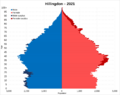
Population pyramid of Hillingdon in 2021, showing the number of people by age and gender.
See also
 In Spanish: Hillingdon (Distrito londinense) para niños
