West Ealing facts for kids
Quick facts for kids West Ealing |
|
|---|---|
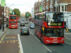
 Two buses in the Broadway, West Ealing |
|
| OS grid reference | TQ153802 |
| London borough | |
| Ceremonial county | Greater London |
| Region | |
| Country | England |
| Sovereign state | United Kingdom |
| Post town | LONDON |
| Postcode district | W13 |
| Dialling code | 020 |
| Police | Metropolitan |
| Fire | London |
| Ambulance | London |
| EU Parliament | London |
| UK Parliament |
|
| London Assembly |
|
West Ealing is a lively area in West London. It's part of the London Borough of Ealing. This district is about 1.2 kilometers (or three-quarters of a mile) west of Ealing Broadway. Even though people have lived here for a very long time, West Ealing as we know it today is less than 100 years old. West Ealing uses the postcode W13. It's close to other areas like Hanwell, Ealing, Perivale, and Northfields.
Contents
History of West Ealing
Early Days of West Ealing
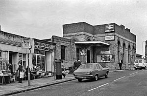
A small village called West Ealing was first mentioned way back in 1234 AD. Later, its name changed to Ealing Dean. When the West Ealing railway station was built in 1871, it was called the Castle Hill & Ealing Dean Station. The name Ealing Dean might come from an old word meaning "valley." It first appeared in records in 1456. On a map of the Ealing area from 1777, you can see it. Back then, most of West Ealing was open countryside. There were only a few houses in Ealing Dean, Drayton Green, and Castle Bear Hill (which is now Castlebar Hill).
In 1387, Drayton Green was known simply as Drayton. Later, it was called Drayton in Ealing. By the late 1800s, Drayton was still a small village with only eight families living there. The area around Drayton Green Lane was later named Steven's Town. It had more than forty small houses.
A main road running east to west became known as the Uxbridge Road. In the 1800s, it was a busy route for stagecoaches. The coach traveling from London to Banbury and Oxford would stop at the Halfway House pub in West Ealing. This pub is now the Broadwalk Hotel. The Green Man pub in West Ealing was a popular stop for people who drove carts. It was said to have stables for 100 horses!
West Ealing in the 1800s
During the 1800s, much of the land in West Ealing was used for growing fruits and vegetables. This area stretched from the Uxbridge Road south to Windmill Road, east to Northfield Avenue, and west to Boston Road. You can still see a hint of this past in the names of a few streets, which are named after types of apples. One of the last remaining signs of this history is the Steel's Fruit Packing Warehouse. It's still there at the corner of Northfield and Northcroft Roads.
Next to these fruit and vegetable farms were allotments. These were small plots of land given to people to grow their own food. They started in 1832 when the Bishop of London gave the area known as Ealing Dean Common (both sides of Northfield Avenue) to the poor people of West Ealing. The allotments on the east side of Northfield Avenue are still the original ones. However, the ones on the west side were built on in the early 1980s.
Ealing Dean was famous in the 1800s for its pony and donkey races. These races took place on what was called Jackass Common, which is now Dean Gardens. The races stopped in 1880 because the local council thought they were not good for the community.
In 1882, the Ealing Lawn Tennis Club started. It was on land between St. Leonards Road and the Great Western Railway (GWR) line. This club quickly became the most successful women's tennis club in the world! Three club members who were born in Ealing won many Wimbledon Singles titles. These amazing players were Blanche Bingley, Charlotte Cooper, and Dorothea Douglass. Together, they won a total of thirteen Wimbledon titles between 1886 and 1906. In 1906, the club moved to Creffield Road in Ealing Common.
In the 1890s, the shops in central West Ealing were less formal than those in central Ealing. West Ealing had (and still has) fruit and vegetable stalls, which were not found in Ealing. West Ealing's main shopping area was very busy in the mid-1900s. Big stores like F. H. Rowse (which sold clothes and home items), W. J. Daniel and Company (a fashion store), Marks and Spencer, British Home Stores, Woolworth, Sainsbury's, and WHSmith were all there. Later, Waitrose, McDonald's, and Blockbuster Video also opened.
The West Ealing Library is on Melbourne Avenue, south of the Uxbridge Road. Its first location, which opened in 1903, was between Melbourne Avenue and St James's Avenue. This spot is now where Sainsbury's is located.
Modern West Ealing
West Ealing used to have a large cinema at the end of Northfield Avenue, near Uxbridge Road. It opened as the Kinema in 1913. This cinema was built where the Ealing Dean Cottage Hospital used to be. In 1928, the cinema was rebuilt and called the Lido. When fewer people started going to the movies, it was split into two smaller cinemas (Studio one and Studio two). The main hall became a bingo hall. After new owners took over, the cinemas became Cannon 1 and 2, and the bingo hall became a snooker hall. With another change of ownership, it was briefly called the Gosai. This was an Indian cinema that mostly showed Bollywood films. It closed down and was torn down in 2005. The site has been redeveloped. The new building, called the Lido Centre, opened in 2007. It is now Ealing's volunteer centre. Above the volunteer work spaces are small apartments for social housing.
More houses were built in the area because of new train lines. The GWR railway station opened at Ealing Dean in 1871. The line was later extended to Greenford through Castle Bar Park railway station and Drayton Green railway station. In 1901, the London United Tramways Company started a tram line from Ealing to Southall. And in 1907, the District Railway opened a small station (a halt) at Northfields.
In the 1920s, many houses were built on the Argyle Park estate. This area is from Argyle Road to the Greenford GWR railway line. Houses were also built along Kent Avenue. Later, new housing developments replaced the allotments west of Northfield Avenue. In 1970, flats were built in Langham Gardens (off Gordon Road). In 1977, the Green Man Lane Estate was built. In the early 1980s, the Berners Drive-Coleridge Square estate was built next to the rebuilt West Middlesex Lawn Tennis club, west of Drayton Green.
Since World War II, West Ealing has seen a lot of rebuilding. Many old Victorian houses have been turned into flats. Some of the big stores like F. H. Rowse's, WHSmith, Marks and Spencer, Woolworth, and McDonald's have left. Newer stores like Wilko have arrived. The Daniel's store has been replaced by a gym under a block of flats. Waitrose replaced its original store with a bigger one. Even though West Ealing's shopping and cultural places have changed, in 2001 it started London's only street market just for farm produce.
Many people from countries like Somalia and Poland have moved to West Ealing. This has led to new housing projects. One example is the Green Man Lane Estate, built in the 1970s, just north of the High Street. This estate is being rebuilt to create new homes for affordable rent, shared ownership, and for sale.
Places of Worship
West Ealing has three Church of England churches. St John's Church is in Mattock Lane, towards the southeast. St James's Church is in St James's Avenue, to the southwest. And St Stephen's Church is in St Stephen's Road, to the north.
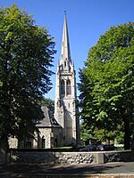
St John's Church was built in 1876 by Edwin Henry Horne. It burned down in 1920 but was rebuilt and reopened in 1923. St James's Church started in 1900. It wasn't used for a while later in the 1900s, but a new group of worshippers started using it again in the late 1980s. St Stephen's Church was founded in 1867. In 1891, a tall spire, almost fifty meters high, was added. This spire still stands out in the Ealing skyline today. The old church building had problems with its foundation, so by 1979, it had to be closed. Sunday services were held in other places. In 1985, it was decided to sell the church building to a developer to turn it into apartments. A new church center was built where the old Church Hall used to be. This new center was finished and opened in 1987.
West Ealing is also home to the West London Islamic Centre (WLIC). This center was started in 1984 to help the growing Muslim community in Ealing and Hanwell. The first Mosque was at 119 and 121 Oaklands Road. It was made from two shops that were changed to fit both men and women. This mosque is currently being rebuilt and will become one of the largest mosques in London.
There are also two Hindu temples in West Ealing. These temples are located in buildings that used to be churches. West Ealing is also where the Ealing Liberal Synagogue is located.
Geography of West Ealing
West Ealing doesn't have official borders, but most of it is in the postcode district W13. The W13 area stretches as far north as Perivale and as far south as Northfields. Six bus routes (E3, E8, 207, 427, 483, 607) go through West Ealing. These buses connect the area to places like Shepherd's Bush, Ealing, Hanwell, Greenford, Acton, and Southall.
Neighbouring Areas
Train Stations in West Ealing
- West Ealing Station (served by the Elizabeth line and Great Western Railway)
- Castle Bar Station
- Drayton Green Station
Nearby Tube and Train Stations
- Boston Manor tube station
- Ealing Broadway station (tube and mainline rail)
- Hanwell station
- Northfields tube station
- Perivale tube station
- South Ealing station
 | Bayard Rustin |
 | Jeannette Carter |
 | Jeremiah A. Brown |


