River Walbrook facts for kids
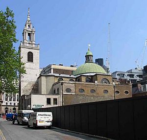
The Walbrook is a hidden river that flows underground in the City of London. It gave its name to a part of the city called the Walbrook City ward and a small street nearby.
The Walbrook is one of many "lost" rivers in London, like the more famous River Fleet. It was super important in the Roman city of Londinium, which is what London was called back then.
Contents
What Does "Walbrook" Mean?
Most people think the name Walbrook comes from old words meaning "brook of the foreigners." This probably meant the native Britons who lived there, who were also called the Welsh. This idea suggests that British-speaking people lived in one part of the city during the Anglo-Saxon period. They might have lived on Cornhill (to the east), while the Saxons lived on Ludgate Hill (to the west).
Another idea is that the river was named Walbrook because it flowed through or under the London Wall.
A writer named Geoffrey of Monmouth linked the name to the many skulls found in the river. He made up a story that the name Gallobroc came from a Roman leader named Livius Gallus who was defeated there.
The main part of the river, which started in Shoreditch, was known as the Deepditch, Flood Ditch, or just The Ditch before it reached the city wall.
How Walbrook Divided London
The Walbrook river split the city into two main hills: Ludgate Hill on the west side and Cornhill on the east side.
It's believed that in the Anglo-Saxon period, London might have had two main leaders, called Stallers. One was for the land west of the river, and one for the east. Even outside the city walls, the river separated land. For example, the Soke of Cripplegate was to the west, and the Soke of Bishopsgate was to the east.
By the 1000s, the two halves of the city had different economies, characters, and rules. The western side was busier and richer. It had the main church (cathedral) and the royal palace (which later moved to Westminster). Its big market, Westcheap, focused on trade that came by land. The eastern side was poorer and had fewer people. Its smaller market, Eastcheap, was near the river, making it good for trade that came by sea.
This division of the city continued, though less strongly, even up to the time of John Stow, who wrote about London in 1603.
Because the name Walbrook might mean "river of foreigners," some think it means a part of the city was home to native Britons (Welsh people). This part is thought to be the eastern side on Cornhill. The Saxons were likely based on the more important western side, Ludgate Hill.
London's Wall and the River
London's big defensive wall seems to have accidentally affected the Walbrook. It acted like a dam, slowing down the river's flow. This created the marshy (swampy) conditions in the open area known as Moorfields. The ditch around the wall might have also sent some water away that would have otherwise flowed through the city.
The Mystery of the Walbrook Skulls
In 1838, workers building a new sewer under Blomfield Street, right where the Walbrook used to be, found a huge number of human skulls. But there were very few other bones.
"An immense number of human skulls were found throughout this street" (meaning Blomfield Street)
Since then, about 300 more heads have been found in the riverbed, mostly near where they were first discovered. People believe that thousands more heads might have been destroyed by building work or are still waiting to be found.
Around 1136, Geoffrey of Monmouth seemed to know about all the skulls in the river. In his book History of the Kings of Britain, he said they came from a huge killing during a Roman civil war (the Carausian Revolt of AD 286–296). In Geoffrey's story, a Roman legion led by Livius Gallus was trapped in London. They agreed to give up to the forces of Julius Asclepiodotus if they could leave Britain safely. Asclepiodotus agreed, but his allies, the Venedoti, attacked the captured Romans and cut off all their heads in one day. Geoffrey wrote that the river was then named after Livius Gallus as Nantgallum in Welsh, or Galobroc in Saxon English, which later became Walbrook. However, Geoffrey's History isn't always accurate, so other ideas have been suggested.
Some historians think these skulls are from the rebellion led by Boudica. More recently, most skulls have been dated to the early 100s AD. This has led to the idea that they are from an anti-Roman rebellion in the 120s, when London had a second big fire, often called the Hadrianic fire.
These three ideas about battles might connect to what archaeologists think: that the skulls were placed there on purpose as part of the Celtic cult of the head, where heads were seen as very important.
Recent digs in Drapers Gardens showed a cemetery where graves had been washed away by the Walbrook. This suggests that some skulls might have come from there.
Where Did the Walbrook Flow?
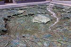
The Walbrook had many smaller streams flowing into it. The exact paths of these streams are not fully known, especially further north, outside London's Wall. Every new excavation in the area helps us understand more.
The paths of the different branches might have changed over time, making it even harder to understand the river's history. These changes could have been natural or caused by people.
Modern maps of Roman London show the Walbrook with many branches. One map, Roman London - a New Map and Guide, shows six branches. Most of these branches were to the west of the main eastern stream.
River Sources
The river seems to have had a main eastern branch that started in Hoxton, in Shoreditch. It also had one or more branches flowing from Finsbury to the west. It's not completely clear, but both of these branches might have started as far north as Islington.
The main branch of the stream, entering the city along Blomfield Street, was called Deepditch. This main stream and some western streams seem to have met in Moorfields, north of the City Wall. The river then flowed south down what is now Blomfield Street, to the east of Finsbury Circus.
Just north of the wall, the main branch (Deepditch) formed the border of the city areas called Coleman Street (to the west) and Bishopsgate Without (to the east).
It then entered the walled part of the City just west of All Hallows-on-the-Wall Church.
Inside London's Wall
The brook flowed south through the middle of the walled city. It brought fresh water and carried waste away to the River Thames at Dowgate. It basically split the city in half.

John Stow, writing in the 1500s, suggested there was a branch called the Langbourne to the east. He thought it started at St Katherine Coleman and flowed southwest along Fenchurch Street (making this area "fenny" or marshy), then along Lombard Street, into Sherbourne Lane, and probably into the Walbrook. Later experts have doubted this.
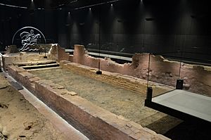
The Walbrook came out just west of the current Cannon Street Railway Bridge. In Roman times, people also used it for transport. Boats could go about 200 meters from the Thames, to where the Bucklersbury building is now. There, the Romans built a port and a temple to Mithras on the east bank of the stream. This temple was found and dug up after World War II. The Roman Governor's palace was found further down the east bank, near where the stream met the Thames.
The River Disappears
In the 1400s, the monasteries of Charterhouse and St Bartholomews moved the Walbrook's upper waters to their sites in the River Fleet area. Some think this greatly reduced the Walbrook's flow.
When the church of St Margaret Lothbury was rebuilt in 1440, the Lord Mayor Robert Large paid to have the lower Walbrook covered over. By the time of the first maps of the area, like the "copperplate" map from the 1550s, the entire Walbrook inside the city walls was covered with a culvert (an underground pipe or channel). John Stow, the historian, wrote in 1598 that the river, which used to have several bridges, was later covered with brick and paved over. Houses were built on top, so the stream was hidden, just like it is today.
Modern Times
When London built its huge London sewerage system with five main sewers, it used many existing culverts and channels. This included the covered Walbrook. By 1860, the Walbrook was connected to a network of 82 miles of new sewer lines. It flowed into the Northern Low Level Sewer near the Bank of England. Many small leaks still stream into the rounded sewer for much of the year when the water table (the level of water underground) is high enough.
On June 18, 1999, during a protest called the "Carnival Against Capitalism" (which happened at the same time as the 25th G8 summit), fire hydrants were opened along the path of the Walbrook by a group called Reclaim the Streets. This was a symbolic act to "release" the river and "reclaim the street" from the "capitalist forces" of city growth that had hidden it.
|
 | Chris Smalls |
 | Fred Hampton |
 | Ralph Abernathy |


