
Copperplate map of London facts for kids


The "Copperplate" map of London is a very old and large map of the City of London and the areas around it. It was created between 1553 and 1559. This map is special because it's the first real map of London, unlike earlier pictures that were more like panoramic views.
The original map was probably meant to hang on a wall. It was huge, about 112 cm tall and 226 cm wide! We don't have any copies of the printed map today. But, between 1962 and 1997, three of the original copper printing plates were found. There were probably 15 plates in total. Even though we only have a few pieces, these three plates show most of the main part of the City of London.
The map looks like a "bird's-flight view". This means the streets and ground are shown as if you're looking straight down from above. But buildings, people, and other tall things are shown as if you're looking at them from a high point to the south of the city.
This Copperplate map was used as a guide for other maps made later. For example, the slightly smaller ""Woodcut" map" from after 1561 copied from it. Also, a map of London in a famous book called Civitates Orbis Terrarum (published in 1572) used information from the Copperplate map. These other maps help us guess how big the original Copperplate map was.
Contents
How the Map Was Made
The Copperplate map might have been made by mapmakers from the Low Countries (like modern-day Netherlands and Belgium). This area was famous for making maps and printing back then. Some clues on the map suggest this.
The map was made around the time Queen Mary I and her husband Philip of Spain ruled (1554–1558). King Philip loved collecting city maps. He might have asked for this map to be made or helped pay for it. Some people also think that German merchants in London or a scholar named George Lily helped create it.
The three copper plates we have are very worn out. This suggests they were used many times to print copies of the map.
The Plates We Still Have

Only three of the original copper plates have been found. They show different parts of London.
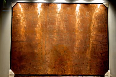
The Moorfields Plate
The first plate was found in 1962. It shows the northern edge of the City of London. This includes part of the old city wall, the gates of Moorgate and Bishopsgate, and the areas called Moorfields and Spitalfields.
Interestingly, the back of this plate was used later for a painting of the Tower of Babel. This painting was made around 1600. The London Museum bought this plate, and it's now at the Museum of London.

The Eastern City Plate
The second plate was found soon after the first one. It shows much of the eastern part of the City. This area is just south of the Moorfields plate's section and goes down to the River Thames. It includes important places like Guildhall and the northern end of London Bridge.
The back of this plate was also reused for a painting. This one shows the "Coronation and Assumption of the Virgin" and was painted around 1600. The Museum of London bought this plate in 1985.

The Western City Plate
The third plate was found in 1997 in a museum in Germany. This part of the map shows much of the western City. It's just west of the Eastern City plate's area and also reaches the Thames. Famous landmarks like St Paul's Cathedral and the River Fleet are clearly visible here.
Like the first plate, the back of this one was used for another painting of the Tower of Babel, made around 1630.
How We Know the Map's Age
The Copperplate map doesn't have a date printed on it. However, experts have figured out it was made between 1553 and 1559 by looking at details on the map itself.
For example:
- St Paul's Cathedral is shown with its tall spire. This spire was destroyed in a fire in 1561. So, the map must have been made before then.
- The Royal Exchange is not on the map. This important building was built between 1566 and 1570. This tells us the map was made before the Royal Exchange existed.
- A cross in the churchyard of St Botolph-without-Bishopsgate is shown. This cross was removed in 1559.
These kinds of clues help historians pinpoint when the map was created.
Gallery
- Copper plates held in the Museum of London
-
Moorfields plate: printing surface
-
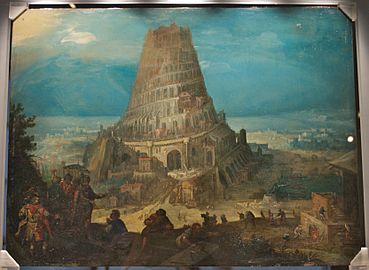
Moorfields plate, reverse: The Tower of Babel, c.1600
-
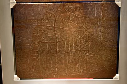
Eastern City plate: printing surface
-
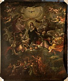
Eastern City plate, reverse: The Coronation and Assumption of the Virgin, c.1600


