
Jubilee River facts for kids

The Jubilee River is a special channel built in southern England. It's about 11.6 kilometers (7.2 miles) long and around 45 meters (148 feet) wide. This river was created in the late 1990s and early 2000s. Its main job is to take extra water from the River Thames. This helps stop flooding in towns like Maidenhead, Windsor, and Eton.
The Jubilee River works by taking water from the Thames near Maidenhead. It then carries this water and returns it to the Thames further downstream, past Eton. While it has helped these towns, some people in villages like Wraysbury believe it has made flooding worse for them.
Building the River
Towns like Windsor, Eton, and Maidenhead often flooded because they are built on the flat land next to the River Thames. In the 1980s, people came up with the idea of building a new channel. This channel would take water from the Thames above Maidenhead and put it back below Windsor. This project was called the Maidenhead, Windsor and Eton Flood Alleviation Scheme.
The plans for this new channel were made in the early 1990s. It was designed to be 50 meters (164 feet) wide and 12 kilometers (7.5 miles) long. The government approved the project in 1995. The Environment Agency was in charge of building it. The total cost was about £110 million.

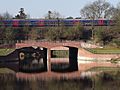
One big challenge was building the Dorney Bridge. This bridge was needed to carry the Great Western Railway line over the new river. The railway embankment, built in the 1800s by Isambard Kingdom Brunel, had to stay open for trains during construction. To do this, engineers froze the ground under the embankment for three months. They used 175 special tubes cooled to -25 degrees Celsius (-13 degrees Fahrenheit). Then, they dug a tunnel through the frozen ground. They pushed two large concrete sections, each 50 meters (164 feet) long, through this tunnel. This created a strong concrete tunnel, called a culvert, for the river to flow through.

The new channel also had to pass under the Black Potts Viaduct. This is an old bridge with 13 brick arches that carries another railway line. Workers built protective concrete walls around the old brickwork to keep the viaduct safe. They also added special gates to control how much water flows back into the Thames there.
Building the 11.6-kilometer (7.2-mile) channel was a huge engineering task. It involved moving utility pipes, building new roads, and dealing with railways. It also meant working with local communities and buying some land. For example, a weir was built at Manor Farm. The whole project, from idea to completion, took about 20 years.
Water enters the Jubilee River through special gates called sluices near Taplow. These gates are controlled by checking the water levels in the Thames and how much water is flowing. In January 2003, the river faced its first big test during a flood. There were some problems with the design. The banks of the river were damaged in several places, and a weir was bent. Experts found that the river could only handle about two-thirds of the water it was designed for. This was because the banks were too low and the wrong materials were used. Repairs cost £3.5 million and were finished in 2006.
Why the Name Jubilee?
During the planning stage, the project was known as the "Maidenhead, Windsor and Eton Flood Alleviation Scheme." But when it was time to name the new river, local people were asked to vote. Most people chose 'Jubilee'. This was because the river was finished in 2002, which was Queen Elizabeth II's Golden Jubilee year. Also, Windsor Castle, one of the Queen's homes, is in Windsor, one of the towns the river protects.
The River Today
The Jubilee River looks and feels like a natural river. Its banks have special areas built for wildlife. These areas help replace habitats that were lost from the Thames banks over time. During construction, workers created 38 hectares (94 acres) of reed beds and 5 hectares (12 acres) of wet woodland. They also planted about 250,000 trees.
Many people enjoy the Jubilee River. Walkers, runners, swimmers, canoeists, and cyclists use it often. A footpath and National Cycle Route 61 run almost its entire length. You can see many different birds along the river, like green woodpeckers, cormorants, and red kites.
In early 2014, there was a lot of flooding. Some people in villages like Ham Island and Wraysbury said that the Jubilee River made the flooding worse for them. These villages saw water levels higher than they had been since 1947. The Environment Agency is now working to make the Thames wider and deeper to help with water flow downstream.
Images for kids
-
Dorney Bridge

