River Tyburn facts for kids
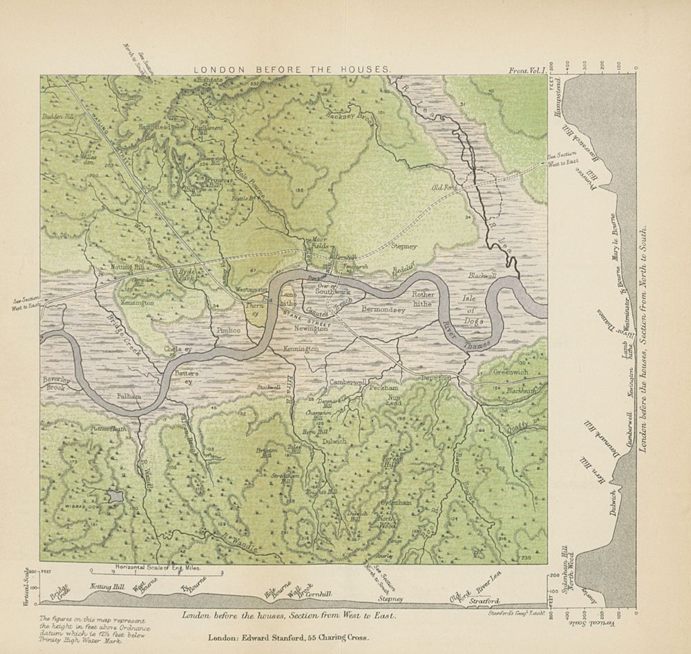
The River Tyburn was a small river, also called a bourn, that once flowed through London. Today, its path is mostly followed by underground sewers. It was similar to the River Colne in Middlesex because it had many branches, called distributaries, that split off from the main river.
The Tyburn started in South Hampstead. It then flowed through areas like Marylebone and Soho. After that, it went through St James's and Green Park. Finally, it met the tidal River Thames in four different spots. These spots were near Whitehall Stairs (close to Downing Street) and by Thorney Street, between Millbank Tower and Thames House. A smaller river, the Tyburn Brook, was a branch of the Westbourne. The Westbourne was the next river to join the River Thames to the west.
An old document from the year 959 AD seems to mention the river. It called it Merfleot, which probably means Boundary Stream. This name makes sense because the river formed the western edge of the land described in the document.
Contents
Where Did the Tyburn River Flow?
Before it was covered up and turned into a sewer, this 7-mile-long river started where two streams met. This was in the hills of South Hampstead, in the wide valley between Barrow and Primrose Hills. Its main starting point was a spring called Shepherd's Well, near Fitzjohn's Avenue in Hampstead.
How the River Split
When the river reached Green Park, its waters split into several branches. These branches helped create Thorney Island, which is where Westminster Abbey was built. As old maps show, these branches split again. One branch went to a lower area where Whitehall now stands. This area used to get covered by water during high tides. Another branch flowed close to Vincent Square in Pimlico, Westminster.
Most of the water from the Tyburn area now soaks into the ground. It either goes into the chalk water deep below or into the modern drainage systems built in Victorian London. There's even a related drain under Buckingham Palace. The path of the old river is now used by important underground pipes, called sewers. These sewers connect to the large system built by Joseph Bazalgette that carries waste from west to east across London.
Following the Old Path
Some streets in London still show where the river used to flow. These include Marylebone Lane, Jason Street, Gees Court, South Molton Lane, and Bruton Lane. Many of these streets don't follow the usual straight grid pattern of London's roads. This is because they were built along the winding path of the old stream.
From its source at Shepherd's Well in Hampstead, the river's path is now followed by the Scholar's Pond Sewer. This sewer runs south along Fitzjohn's Avenue, through Swiss Cottage in South Hampstead, and under Avenue Road to Regent's Park. To get into the park, the sewer pipe goes over the Regent's Canal and then continues underground.
The Tyburn's Name and History
The River Tyburn gave its name to an old area called Tyburn. This area was once a manor (a large estate) in Marylebone. It was even mentioned in the Domesday Book, a famous survey from 1086. Tyburn was located roughly at the west end of what is now Oxford Street. For many centuries, from the late Middle Ages until the 1700s, this spot was known for its gallows. People who were found guilty of serious crimes against the country were taken there.
The river's name also lives on in the names of older roads that became Oxford Street and Park Lane. These roads were once known as Tyburn Road and Tyburn Lane.
Is the River Still Visible?
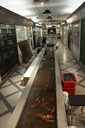
There's an antiques shop called Grays Antique Centre near Oxford Street and Davies Street. The shop claims that a small stream of water you can see in its basement is part of the River Tyburn. It's true that the shop is very close to where the river used to flow underground. However, the Londonist website suggests this idea is more of a fun story than a fact. This is because the modern Tyburn is now a sewer, not a natural river.
The River's Final Paths
The southern part of the stream followed Lansdowne Row, the northeast of Curzon Street, then White Horse Street, and the walking path of Green Park. It went to the front gates of Buckingham Palace. From there, one branch of the river used the low-lying area of St James's Park Lake and Downing Street to reach two closely placed mouths.
A third branch of the river is harder to trace because of all the buildings and streets. It went towards Thorney Street, near Lambeth Bridge. A fourth branch naturally collected water for a 3-meter-wide sewer pipe called King's Scholar's Pond Sewer. This sewer connects to a large interceptor sewer along the Victoria Embankment. This system prevents the water from flowing out into the Thames west of Vauxhall Bridge.
 | Anna J. Cooper |
 | Mary McLeod Bethune |
 | Lillie Mae Bradford |


