
Cricklade facts for kids
Quick facts for kids Cricklade |
|
|---|---|
 Jubilee Clock and part of the High Street |
|
 Snake's head fritillaries in the National Nature Reserve, with the Anglican church behind |
|

Cricklade
|
|
| Population | 4,253 (2021 Census) |
| OS grid reference | SU101936 |
| Civil parish |
|
| Unitary authority |
|
| Ceremonial county | |
| Region | |
| Country | England |
| Sovereign state | United Kingdom |
| Post town | Swindon |
| Postcode district | SN6 |
| Dialling code | 01793 |
| Police | Wiltshire |
| Fire | Wiltshire |
| Ambulance | Great Western |
| EU Parliament | South West England |
| UK Parliament |
|
Cricklade is a historic town in north Wiltshire, England. It sits right on the River Thames, about halfway between the larger towns of Swindon and Cirencester. It's special because it's the very first town you reach as you travel downstream along the Thames. In 2021, about 4,253 people lived in Cricklade. It's also a civil parish, which means it has its own local council that manages some town services.
Contents
- What is the History of Cricklade?
- How is Cricklade Governed?
- What Sports and Activities are Popular in Cricklade?
- What Nature Spots Can You Find in Cricklade?
- What Schools are in Cricklade?
- What Churches are in Cricklade?
- Motto, Blooms, and Twinning
- Business and Economy in Cricklade
- Media in Cricklade
- Notable People from Cricklade
- How to Get Around Cricklade?
- Images for kids
- See also
What is the History of Cricklade?
Cricklade was founded a long time ago, in the 800s, by the Anglo-Saxons. It was built where the old Roman road called Ermin Way crossed the River Thames. From 979 to 1100, Cricklade even had its own royal mint, making coins for the king! You can see some of these old coins in the town museum today. The Domesday Book, a famous survey from 1086, mentions Cricklade as Crichelade, with a church and its own local area called a hundred.
How was Cricklade a Stronghold in Anglo-Saxon Times?
Cricklade was one of about 30 special fortresses or fortified towns called burhs. These were built by King Alfred around Wessex to protect against the Vikings. Experts think these strongholds were built quickly in 878–879. They helped defend Wessex and push back the Vikings who were based nearby in Cirencester. The Anglo-Saxon Chronicle says that once these defenses were ready, the Vikings left the area.
Building the Fortifications
The defenses of Cricklade were square-shaped. Archaeologists have dug in many places and learned a lot about them. First, there was a bank of earth and clay with three ditches outside it. Later, a strong stone wall was added to the front of the bank. This made the town much safer. This stone wall was likely added around the 890s as part of a big upgrade to defenses across Wessex.
Changes to the Walls Over Time
Later, the stone wall was deliberately taken down. The stones were used to fill in the ditches, showing it was a planned action. This might have happened when King Cnut became king in the early 1000s. He might have wanted to prevent rivals from using these strongholds against him. Even later, during a civil war in 1144, the old Anglo-Saxon defenses were used again. A wooden fence was put up where the stone wall used to be.
Life Inside the Fort
We don't have much archaeological evidence about the people who lived inside these defenses. However, it seems the streets were laid out in a neat pattern behind the main High Street. A gate in the northern wall led to a causeway and a bridge over the Thames, which was probably also part of the defenses.
Other Nearby Settlements
Widhill, a small area south-east of Cricklade, was once part of Cricklade parish. In 1934, its boundary was changed. Other small areas in Cricklade parish include Calcutt, Chelworth Lower Green, Chelworth Upper Green, Hailstone Hill, and Horsey Down.
Later History of Cricklade
On a map from 1611 by John Speed, the town's name was spelled Crekelade. The Cricklade Museum has many books and items about the town's history and its people.
A special clock called the Jubilee Clock stands on the High Street. It's on a cast-iron pillar and was put up in 1897 to celebrate Queen Victoria's Diamond Jubilee.
How is Cricklade Governed?
Cricklade has a town council elected by its residents. This council handles local matters. Most bigger local government jobs are done by Wiltshire Council, which is the main authority for the wider area.
Cricklade is part of an electoral ward called Cricklade and Latton. This ward includes Cricklade and its northern neighbors, Latton and Marston Maisey. This ward elects one person to the Wiltshire Council.
For national elections, Cricklade is in the South Cotswolds parliamentary area. In the past, Cricklade had its own Member of Parliament (MP) and even two MPs at one point! The area it represented changed over time, even including Swindon when it was just a village. The current South Cotswolds constituency was created for the 2024 general election.
What Sports and Activities are Popular in Cricklade?
Rugby Union
Cricklade Rugby Club started in 1992. At first, they played games on Sundays because many players were busy with other clubs on Saturdays. They joined the Dorset and Wilts leagues in 1994. Since 2001, the club has played on a special pitch in town, leased from the town council. The club has traveled to play games in England, Wales, and Ireland.
Shows and Festivals
The Cricklade Show happens every summer. It usually has music, dancing, and a cricket match. The town also has an annual festival, often held on Father's Day in June.
Charity Sports Events
Every first Sunday in October, the Cricklade Fun Run takes place. It includes a half marathon, a 10 km race, and a shorter fun run. Around 750 runners take part, raising money for local charities. The Cricklade Triathlon is held in the summer for both adults and younger athletes.
Leisure Centre
In 2006, the local council planned to close the leisure centre. But local residents campaigned and took over running it themselves! It now has a swimming pool, a sports hall, a bar and lounge, a skate park, and play areas for kids. In 2009, they even raised money for a climbing wall.
Cricket
Cricklade Cricket Club was formed in 1877. Since 1947, their ground, called Southam, has been next to the River Thames on the north side of town. The club has several teams for different ages and skill levels.
Association Football (Soccer)
Cricklade Town F.C. is a local soccer team that plays at the Cricklade Leisure Centre. Cricklade Youth Football Club helps young people from ages 7 to 16 play soccer. It was the first club in Wiltshire to get the Wiltshire FA Charter Standard award, which means it meets high standards set by the Football Association.
Cricklade Cinema
Since 2013, the Cricklade Town Hall has shown movies once a month from September to April. They show new films, old classics, and independent movies.
What Nature Spots Can You Find in Cricklade?
North Meadow
North Meadow is a large nature reserve. It's famous for having about 80% of Britain's wild snake's head fritillaries. These beautiful flowers grow in its 150 acres (60 hectares). The meadow is between the Thames and the Churn, and winter floods create a perfect home for the fritillaries. Many such meadows were lost in Britain, but North Meadow was saved because of an old Saxon system of town governance. Now, Natural England helps manage it.
Blakehill
In 2000, an old airfield called RAF Blakehill Farm was bought by Wiltshire Wildlife Trust. It's now a huge meadow of about 600 acres (240 hectares) and opened to the public in 2005. It even raises a small amount of organic beef from rare breeds like English Longhorn cows.
Cotswold Water Park
Cricklade is located between the two parts of the Cotswold Water Park. This is a very large nature reserve made from old gravel pits that are now filled with water.
What Schools are in Cricklade?
St Sampson's C of E Primary School
St Sampson's Church of England School is a state primary school. It's connected to the big local church, St Sampson's. In 1979, it split into two schools on the same site: an Infants' School (ages 4–7) and a Junior School (ages 7–11). In 2014, they joined back together to form St Sampson's C of E Primary School.
Cricklade Manor Preparatory School
This is a private school for about 200 students aged 3–13. It's in a beautiful old building called the Manor House, built in the late 1800s.
What Churches are in Cricklade?
Anglican Churches

St Sampson's is the main Church of England parish church in town. It dates back to the 1100s, but parts of an even older Saxon church from 890 AD can still be seen. The main part of the church was built between 1240 and 1280. The tall tower with four spires, which is a major landmark, was added in the 1550s. This church is a very important historic building.

St Mary's Church, also very old, dates from the 1100s. It used to be an Anglican church but was given to the Catholic community in 1984. It stands just inside the old Saxon town wall. In its churchyard, there's a complete limestone cross from the 1300s, which is also a very important historical structure.
United Church
Cricklade United Church was built by a group called Congregationalists in 1878. The congregation later joined with Methodists to form the Cricklade United Reformed and Methodist Church.
Motto, Blooms, and Twinning
Cricklade's Latin motto is In Loco Delicioso, which means "in a pleasant place." The town has won awards for its beautiful flowers! In 2008, it was named Best Small Town in the UK in the Royal Horticultural Society's Britain in Bloom Finals. In 2011, it won the Champion of Champions award in the same competition.
Cricklade has been twinned with Sucé-sur-Erdre, a town in France, since 1990. They celebrate this friendship by exchanging visits every other year. Sucé is near Nantes in the Loire Valley, about 30 miles (48 km) from the Atlantic coast.
Business and Economy in Cricklade
The Cricklade Business Association helps local businesses. They work closely with other groups in town. Many people in Cricklade are retired, according to the 2011 census.
The local museum on Calcutt Street is run by the Cricklade Historical Society. It's in an old Baptist chapel. T. R. Thomson, who lived in Cricklade for a long time, helped start the society and wrote books about the town's history.
Media in Cricklade
Local news and TV shows come from BBC South and BBC West on BBC One, and from ITV Meridian and ITV West Country on ITV1.
You can listen to local radio stations like BBC Radio Wiltshire (103.5 FM), Heart West (97.2 FM), and Greatest Hits Radio South West (107.7 FM). Swindon 105.5 is a community radio station from nearby Swindon.
The local newspapers for Cricklade are the Swindon Advertiser and the Gazette and Herald.
Notable People from Cricklade
Here are some interesting people connected to Cricklade:
- Robert of Cricklade (born around 1100) was a teacher and writer.
- John Hungerford (around 1566–1635) was a politician who helped build the market house in Cricklade.
- Robert Jenner (1584–1651), a merchant and politician, started a school in Cricklade.
- Nevil Maskelyne (1611–1679) was an MP for Cricklade. He helped the town get a weekly market and four fairs each year.
- George R. Poulton (1828-1867), who wrote the famous American song "Aura", was born here.
- Reginald Arkell (1882–1959), a scriptwriter and novelist, died in Cricklade.
- Ellis Peters (1913–1995), a mystery novelist, set one of her medieval books, Brother Cadfael's Penance, in Cricklade.
- Francis Maddison (1927–2006), a historian, led archaeological digs in Cricklade.
How to Get Around Cricklade?
The Thames Path, a long walking trail, goes through Cricklade. The North Wilts Canal, which opened in 1819, used to pass west of the town. It connected two other canals. It was closed in the early 1900s, but parts of it are now being restored. The Town Bridge, built in 1812, marks how far boats can travel on the River Thames.
The Cricklade railway station used to connect Swindon and Cirencester, but it closed in 1961. Now, part of the old railway line is a cycle path. South of town, the Swindon and Cricklade Railway is restoring the line for fun trips. You can ride passenger trains between Blunsdon and Hayes Knoll. The line is also being extended towards Cricklade. The closest main train station is Swindon.
The A419 road, which goes from Swindon to Cirencester, goes around the north-east of the town. Stagecoach West runs an hourly bus service (route 51) through Cricklade between Swindon and Cirencester.
Images for kids
-
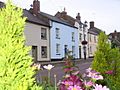
Large Georgian homes in central Cricklade

See also
 In Spanish: Cricklade para niños
