
Cotswold Water Park facts for kids


The Cotswold Water Park is the United Kingdom's largest group of lakes. It sits on the border between Wiltshire and Gloucestershire, near Cricklade and Cirencester. These lakes were made in the second half of the 1900s. Workers dug out gravel from the ground, and when they stopped, the holes filled up with water naturally.
Even though it's called a "Water Park," it's not like a theme park with rides. Instead, it's a very important place for wildlife, especially for birds that live there all year or visit in winter. Local wildlife groups, like the Gloucestershire Wildlife Trust and Wiltshire Wildlife Trust, work with the Cotswold Water Park Trust. They help protect the area for both people and animals. The park covers about 40 square miles and offers many fun activities like sailing and fishing.
There are 147 lakes in total. The area is a mix of nature reserves, places for fun activities, small villages, and holiday homes. It's known as a Key Wildlife Site, which means it's very important for nature.
Contents
Where is the Water Park?
The Cotswold Water Park is huge, covering about the same area as the island of Jersey. It's located in the Upper River Thames area. For easier understanding, the park is divided into three main sections.
- The western section includes villages like South Cerney, Ashton Keynes, and Somerford Keynes. It's also where the River Thames begins, along with other smaller rivers.
- The central section has villages such as Driffield and Cricklade. More lakes were created here in the 1990s when more gravel was dug out.
- The eastern section covers towns like Fairford, Kempsford, and Lechlade. This is where the River Thames becomes wide enough for boats to travel on it.
The park is in a river valley, so the water levels can change. Many fields here are flood meadows that soak up water from the River Thames. Many lakes are connected underground, allowing water to move between them. This helps store floodwater and creates important homes for many different animals and plants.
Cotswold Water Park Trust Nature Reserves
The Cotswold Water Park Trust looks after several special areas within the park. These places are managed to protect nature, allow public access, and offer educational opportunities. They are safe havens for many creatures, including bats, dragonflies, birds, and butterflies. The Trust works to protect and improve these areas for all the different species that live there. They also keep track of the wildlife by doing regular surveys.
Cleveland Lakes Reserve
Cleveland Lakes Reserve includes two large lakes and a reedbed. It has paths for walking and cycling, plus three special hides where you can watch birds without disturbing them. It's a key spot for birds like coots, great crested grebes, and grey herons. New reedbeds have been made, offering more homes for birds. You might also spot otters and water voles here!
Coke's Pit Lake (Local Nature Reserve)
Coke's Pit Lake is a 3.2-hectare (about 8-acre) site. It was dug out about 40 years ago and became a Local Nature Reserve in 2003. It's one of the oldest gravel pits in the upper River Thames Valley. The lake is unusually deep.
This reserve is a breeding ground for birds like reed buntings, tufted ducks, and black-headed gulls. Many dragonfly species also live here, and you might see water voles and nightingales.
Elmlea Meadows (SSSI)
Elmlea Meadows is a special area called a Site of Special Scientific Interest (SSSI). It's important because it has rare plants like the downy-fruited sedge and the beautiful snake's head fritillary flower.
Old Railway Line
An old railway line, which used to be part of the Midland and South Western Junction Railway, now acts as a wildlife corridor. It's a long, narrow strip of land that connects different natural areas between South Cerney and Cricklade, helping animals move safely.
Shorncote Reedbed
Shorncote Reedbed is a special area designed to attract wetland birds. It has several long islands that create lots of edges for reeds to grow, which birds love. Birds like bitterns, water rails, and snipe visit this peaceful spot. Otters and water voles have also been seen here. There are two bird hides for visitors.
Waterhay Reedbeds
This area used to be a lagoon where silt (fine mud) from the gravel workings settled. Now, it's a natural habitat that provides a home for birds that visit in winter or breed there. It's also a safe place for reptiles and small mammals.
Sites of Special Scientific Interest (SSSI)
| Site of Special Scientific Interest | |
| Area of Search | Gloucestershire and Wiltshire |
|---|---|
| Grid reference | SU0093 to SU2099 |
| Interest | Biological |
| Area | 135 hectare |
| Notification | 1994 |
Only a few of the lakes in the Cotswold Water Park are open for public use. A large part of the park, covering 135 hectares (about 334 acres), was named a Site of Special Scientific Interest (SSSI) in 1994. This means it's a nationally important area for its wildlife. In 2021, even more areas were given SSSI status to protect them further.
Gloucestershire Wildlife Trust Reserves
The Gloucestershire Wildlife Trust manages four nature reserves in the eastern part of the Cotswold Water Park. These are Whelford Pools, Edward Richardson & Phyllis Amey, Roundhouse Lake, and Bryworth Lane.
Whelford Pools Reserve (SSSI)
Whelford Pools are located between Fairford and Lechlade. The Gloucestershire Wildlife Trust bought this site in 1979. The pools are important for birds that spend the winter there, as well as for breeding birds, dragonflies, and plants. Many tufted ducks, pochards, and Canada geese spend their winters here. You can also see kingfishers and sedge warblers breeding.
Dragonflies like the emperor dragonfly and migrant hawker also breed here. The site is the only known place in Gloucestershire for a tiny type of mussel.
Edward Richardson and Phyllis Amey Reserve
This reserve is an 11.1-hectare (about 27-acre) site with two gravel pits. It's named after a former site manager and the sister of a company chairman. The pits were created by digging out gravel, and the lakes are quite shallow. A nature trail lets you explore the different habitats, like scrub, wet woodland, and reedbeds.
Many different plants grow here, including colourful southern marsh-orchids and bee orchids. You can also find a lot of dragonflies and damselflies. The area is great for birdwatching all year round. You might see common moorhens, Eurasian coots, and mallards. In winter, birds like Eurasian wigeon and Eurasian teal visit. Great crested newts, frogs, and toads also breed in the ponds.
Roundhouse Lake Reserve (SSSI)
Roundhouse Lake is a large 17-hectare (about 42-acre) lake. It's a popular spot for many birds that spend the winter, such as wigeons and goldeneyes. Great crested grebes and little grebes visit often, and kingfishers have been seen. There's a hide where you can watch the birds. Eurasian otters are also known to visit the lake regularly.
Bryworth Lane Reserve
The Bryworth Lane reserve is a 0.6-hectare (about 1.5-acre) site. It's a 300-yard stretch of an old, unused railway line between Lechlade and Fairford. This old railway line was bought in 1990 and is now a safe haven for wildlife.
The area is raised above the nearby fields and has many different plants, including those found in grasslands, scrub, and woodlands. You can find colourful flowers like field scabious, lady's bedstraw, and oxeye daisys. In spring, cowslips bloom.
The reserve is home to many butterflies, with 21 different species recorded, including the brown argus and marbled white. The bushes and trees provide safe places for birds to nest and for Eurasian sparrowhawks to hunt.
Wiltshire Wildlife Trust Reserves
The Wiltshire Wildlife Trust manages three important reserves in or near the Cotswold Water Park that are also SSSIs. These are Clattinger Farm, Mallard Lake (Lower Moor Farm), and Upper Waterhay.
Clattinger Farm Reserve (SSSI)
Clattinger Farm is a 60.33-hectare (about 149-acre) site near Malmesbury. It's a fantastic example of a traditional hay meadow, which means it's been farmed without artificial chemicals. This makes it incredibly important for nature, especially for its wildflowers.
Mallard Lake Reserve (SSSI) (Lower Moor Farm Reserve)
Mallard Lake is a 13-hectare (about 32-acre) site that is part of the larger Lower Moor Farm reserve. This reserve covers 38.35 hectares (about 95 acres) near Cricklade and Malmesbury. It has three lakes, two brooks, ponds, and wetlands, all connected by old hedges, woodlands, and meadows. The reserve was officially opened in 2007 by Prince Charles (now King Charles III) and the Duchess of Cornwall (now Queen Camilla). It also acts as a "gateway" to other nearby Wiltshire Wildlife Trust reserves.
Upper Waterhay Meadow Reserve (SSSI)
Upper Waterhay Meadow is a 2.82-hectare (about 7-acre) site near Cricklade. It's a specially protected area because it helps protect and support the beautiful snake's head fritillary flower. You can find different colours of this flower here, including the more unusual creamy white ones.
Images for kids
-
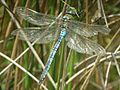
Example: emperor dragonfly (Anax imperator)
-
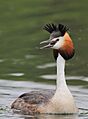
Example: great crested grebe
-
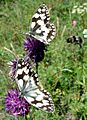
Example: marbled white on knapweed
-
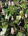
Example: amphibious bistort
-
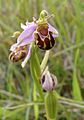
Example: bee orchid (Ophrys apifera)
-
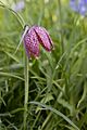
Example: snakeshead fritillary (Fritillaria meleagris)
-
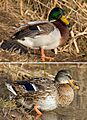
Example: male and female mallard
_-_geograph.org.uk_-_430515.jpg)
.jpg)

_-_geograph.org.uk_-_215891.jpg)

.jpg)

