
River Crouch facts for kids
Quick facts for kids River Crouch |
|
|---|---|
.jpg)
|
|

Map of the River Crouch
|
|
| Country | United Kingdom |
| Region | Essex |
| Towns/Villages | Crays Hill, Ramsden Bellhouse, Wickford, Runwell, Battlesbridge, Hullbridge, South Woodham Ferrers, North Fambridge, South Fambridge, Althorne, Creeksea, Burnham-on-Crouch, Basildon |
| Physical characteristics | |
| Main source | Springs in The Wilderness woods Near Little Burstead, Billericay, Essex 51°36′34″N 00°24′32″E / 51.60944°N 0.40889°E |
| 3rd source | Langdon Hills |
| River mouth | North Sea Between Holliwell Point and Foulness Point 0 ft (0 m) 51°37′36″N 00°56′21″E / 51.62667°N 0.93917°E |
| Length | 17.5 mi (28.2 km), West-east |
| Basin features | |
| Tributaries |
|
| Designation | |
| Official name: Crouch & Roach Estuaries | |
| Designated: | 24 March 1995 |
| Reference #: | 721 |
The River Crouch is a small but important river in Essex, England. It flows all the way through this county. The river is about 17.5 miles (28.2 km) long. This distance covers the part of the river that boats can use, from Holliwell Point near Foulness Island to Battlesbridge.
Long ago, the River Crouch was known by a different name: the Huolve or Wholve. This old name is actually where the town of Hullbridge gets its name from!
Contents
Where the River Crouch Flows
The River Crouch starts in a place called 'The Wilderness'. This is a small pond surrounded by old trees on the Burstead Golf course near Little Burstead. From there, it generally flows towards the east.
As it travels, the river passes by or through several towns and villages:
- Crays Hill
- Ramsden Bellhouse
- The middle of Wickford, where it flows through a concrete channel.
- Runwell
- Battlesbridge, which is as far as boats can travel up the river.
- North of Hullbridge and south of South Woodham Ferrers.
- Between North Fambridge and South Fambridge.
- Althorne
- Creeksea
- Burnham-on-Crouch
Finally, the River Crouch flows into the North Sea. It reaches the sea between Holliwell Point on its north side and Foulness Point on its south side. The River Roach is a major river that joins the Crouch.
Protecting the River Crouch
The River Crouch Conservation Trust
The River Crouch Conservation Trust was started in July 2009. It was created by local people, many of whom were fishermen. They were worried because a part of the river near Memorial Park in Wickford had become very polluted.
The main goal of this trust is to clean up the river. They want to remove rubbish and make the river healthy again. A clean river helps all kinds of wildlife, like water voles, fish, and tiny water creatures. It also makes the river a better place for everyone to enjoy.
The Crouch Harbour Authority
The Crouch Harbour Authority is a special group that looks after the Rivers Crouch and Roach. They also manage a part of the Thames Estuary. Their job is to control how boats and ships use these rivers, whether for fun or for business.
This authority was set up in 1974. It doesn't make a profit and gets its money from fees paid by boats kept on the river. Their tasks include:
- Making and enforcing rules for using the river.
- Helping boats navigate safely.
- Marking the channels where boats can travel.
- Providing important information like weather forecasts and tide times.
The main office for the Harbourmaster is located at the Quay in Burnham-on-Crouch.
Gallery
-
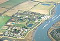
Althorne Marina.
-
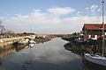
End of the Navigable Crouch at Battlesbridge
-
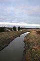
River Crouch South West of Battlesbridge.Taken from the Bridge on the A1245 (TQ775942).
-
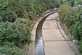
River Crouch, Wickford. Narrow but quite deep!
-
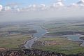
River Crouch, photo taken over South Woodham Ferrers


Images for kids
-
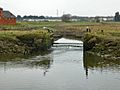
The tide gates which impounded water above them to power Battlesbridge tide mill
.jpg)
