
Prittle Brook facts for kids


Quick facts for kids Prittle Brook |
|
|---|---|
| County | Essex |
| Physical characteristics | |
| Main source | Thundersley Essex 51°33'38"N 0°35'40"E |
| River mouth | River Roach, Rochford 51°34'27"N 0°42'59"E |
| Length | 11.6 km |
The Prittle Brook is a small river, also called a stream, in south Essex, England. It's about 7.2 miles (11.6 km) long. This brook starts in a place called Thundersley and flows through several towns like Hadleigh, Leigh-on-Sea, Westcliff, Prittlewell, and Rochford. Eventually, it joins a bigger river called the River Roach. From there, its water travels to the North Sea through the Roach and Crouch estuaries.
Contents
Journey of the Prittle Brook
The Prittle Brook begins its journey in Thundersley. It flows partly underground in pipes, which are called culverts. It then goes under roads like Rayleigh Road.
As it continues, the brook flows through natural areas like West Wood. It also passes under private properties and roads such as Daws Heath Road. You can see it in places like Dodds Grove Nature Reserve and through Hadleigh Great Wood and Belfairs Wood.
Long ago, the brook used to have many bends, called meanders. After 1920, most of these bends were straightened out.
Joining Other Streams
The Prittle Brook gets bigger as other smaller streams join it. One small stream starts near The Crescent in Hadleigh. It flows east and joins the Prittle Brook near houses in Vardon Drive, Leigh-on-Sea. Another stream comes from Hadleigh Great Wood and meets the brook at the edge of the wood.
From Belfairs, the brook flows east under Eastwood Road. It then mostly follows the path of Manchester Drive and Fairfax Drive. This area is known as the Prittle Brook Greenway. From the end of the Greenway, the brook flows under Victoria Avenue. It then goes through Priory Park and past London Southend Airport. Finally, it reaches Rochford and joins an arm of the River Roach called Fleethall Creek.
The area that collects water for the Prittle Brook is about 20.18 square kilometers (4,987 acres).
The Prittle Brook Greenway
The Prittle Brook Greenway is a special path that is 5.7 kilometers (about 3.5 miles) long. It was officially named the "Prittle Brook Greenway" in 2010. This path is great for walkers and cyclists. It follows the brook from Belfairs, past Southend University Hospital, all the way to Roots Hall. This means you can walk or cycle from Leigh into Southend without using the busy main roads.
This pathway was built in the 1940s. The Prittle Brook flows under several roads along this route. For example, the bridge leading to Our Lady of Lourdes School in Manchester Drive goes right over the brook. Since the 1930s, this part of the brook has become more urban. The banks of the brook east of Belfairs Wood have been lined with concrete. This makes the water flow much faster, especially after heavy rain.
The Prittle Brook Greenway was improved between 2009 and 2012. Sections running next to Blenheim Chase and Prittlewell Chase were made wider and had signs added.
Protecting from Floods
In September 1968, there was a very big flood. The Prittle Brook overflowed its banks and flooded homes in Daws Heath Road, Hadleigh, and around Manchester Drive, Leigh-on-Sea.
After this flood, changes were made to the brook. Some parts were put into culverts (underground pipes), and concrete walls were built along the banks west of Daws Heath Road.
In 1972–73, the Prittle Brook Flood Relief scheme was built. This system helps to control extra water during floods. It takes water from the brook through an inlet west of Eastwood Road. This water then travels through a large underground tunnel. Another entrance to the tunnel is near Manchester Drive. The tunnel is 2.5 meters (about 8 feet) wide and is made of concrete blocks. This tunnel releases the excess water into the River Thames at Chalkwell beach.
The water level in the Prittle Brook is always being watched. There is a monitoring station in Belfairs Park. It has a concrete structure called a flume and special equipment. You can even check the current water level online!
Images for kids
-
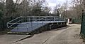
Prittle Brook relief tunnel inlet

