
Mersea Island facts for kids
Quick facts for kids Mersea Island |
|
|---|---|
 West Mersea beach |
|

Mersea Island
|
|
| Population | 6,925 |
| OS grid reference | TM060150 |
| Civil parish |
|
| District |
|
| Shire county | |
| Region | |
| Country | England |
| Sovereign state | United Kingdom |
| Post town | Colchester |
| Postcode district | CO5 |
| Dialling code | 01206 |
| Police | Essex |
| Fire | Essex |
| Ambulance | East of England |
| EU Parliament | East of England |
| UK Parliament |
|
Mersea Island is an island located in Essex, England. It sits where the Blackwater and Colne rivers meet the sea, south-east of Colchester. The name "Mersea" comes from an Old English word, meresig, which means "island of the pool".
The island is divided into two main parts: West Mersea and East Mersea. It is connected to the mainland by a special road called the Strood. This road is a causeway that sometimes gets covered by water during high tide.
People have lived on Mersea Island since before Roman times. During the time of Roman Britain, it was a popular holiday spot for people from Camulodunum (which is now Colchester). Fishing has always been very important here, especially catching oysters. Today, fishing and tourism are big parts of the island's economy.
The Church of St Peter & St Paul in West Mersea might have been built as early as the 7th century. The Church of St Edmund in East Mersea is from around the 12th or 13th century. From the 16th to the 19th century, the island was known for smuggling. Mersea Island was also important during both World Wars, and you can still see old observation posts there. Today, tourism is still popular, with many beach huts and holiday parks. Every summer, there's a fun week-long boat racing event called Mersea Week.
Contents
Exploring Mersea Island's Geography

Mersea Island is about 9 miles (14 km) south of Colchester. It's also about 26 miles (42 km) east of Chelmsford, the county town. This makes it the most easterly island in the UK that people live on and can visit. It's one of 43 tidal islands in Britain that you can reach by foot or car from the mainland.
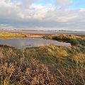
The island covers about 7 square miles (18 km²). It's surrounded by the Pyefleet Channel to the north and the Strood Channel to the west. These channels connect the Blackwater and Colne rivers. Nearby are smaller islands like Ray Island to the north and the uninhabited Packing Marsh and Cobmarsh Islands to the southwest. The area around Mersea Island has lots of saltmarsh and mudflats. These are important places for wading birds and birds that migrate. The island itself is made up of different types of soil, including clay, chalk, sand, and gravel.
Mersea Island is divided into two main parts. West Mersea is where most people live. It has the main jetty and marina. East Mersea is mostly farmland and includes Cudmore Grove County Park. There's also a small village called Barrow Hill north of West Mersea. The area facing the Blackwater River is called the Mersea flats. This is mostly a beach that appears when the tide is low. You can even see the old Bradwell Power Station across the water.
West Mersea has three smaller areas. The Old City in the southwest is where fishing and yachting happen. It has many old, protected buildings. The center of West Mersea has the Church of St Peter & St Paul. The beach and promenade are to the south.
Mersea Island's Economy and Industries

The main ways people make a living on Mersea Island are farming, fishing, and helping with leisure boating and yachting. People have been harvesting oysters from the island's waters since Roman times. These oysters are sent all over the world. The long history of oyster farming brings many tourists to the island each year. Today, most of the oysters are Pacific oysters, which were brought to the area. Every September, the Mayor of Colchester officially opens the Essex oyster fishing season.
The Company Shed restaurant on the west side of the island serves fresh seafood. It's known for its good quality food. Many small shops and ice cream stands serve tourists along Mersea's seafront. The Two Sugars Cafe is even built inside an old pillbox from World War II, right by the beach.
There are six places on the island where people can go camping or stay in caravans. These sites help the island's economy a lot during the summer. Cooper's Beach is the biggest, and it can host up to 3,000 visitors.
A Look at Mersea Island's History

We know that people lived on Mersea Island before the Romans arrived. There are "red hills" which are the remains of ancient Celtic salt-making sites. Near the Strood, a large Roman-British burial mound was found. It held the ashes of an adult in a glass jar, inside a lead box. This is now in the local Mersea Museum. In the 1700s, a large mosaic floor was found under the Church of St Peter & St Paul in West Mersea. More Roman remains were found around the church later. People believe West Mersea was a holiday spot for Romans visiting Camulodunum (Colchester).
Evidence shows that fish traps were used around the island from about the 7th century. The Anglo-Saxons built a big fish trap at Besom Fleet, southwest of the island. They also built the church at West Mersea. Norse raiders damaged it in 894, but it was rebuilt. Parts were added to the church over many centuries, like the west tower around the 11th century.
The Strood causeway was also built by the Saxons. Wooden poles found in 1978 show it was built between 684 and 702. By 950, there was a Benedictine priory (a type of monastery) in West Mersea. In 1046, Edward the Confessor gave land here to the Abbey of St Ouen in France. The priory lasted until the Dissolution of the Monasteries in 1542.
The Parish Church of St Edmund in East Mersea dates from around the 12th or 13th century. It had additions in the late 15th or 16th century. The church and hall are surrounded by a moat. This moat might be what's left of a place where Danish people took refuge after King Alfred defeated them.
During the English Civil War in 1648, the Parliamentary Army built a blockhouse (a small fort) at East Mersea. Their goal was to block the River Colne during the Siege of Colchester. Some ruins of this blockhouse, known as the Block House Stone, are still there and are protected. Fishing became more important on the island during this time. Many fish traps were put in place. In the 16th and 17th centuries, settlers from the Dutch and French arrived. Some locals earned extra money by smuggling, which was popular until the mid-1800s. Smugglers often used the Peldon Rose inn, north of the Strood, to hide illegal goods. In the early 1800s, people started bringing oysters from other places and selling them as Mersea oysters because there weren't enough local ones.

By the late 1800s, some land around the island was reclaimed, making it easier to get around. A police officer was assigned to the island in 1844, and a school opened in 1871.
In the First World War, 320 soldiers from Mersea Island fought, and 50 of them died. They are remembered at the War Memorial at the parish church. Troops were stationed on Mersea Island during the war. In 1916, a Zeppelin (a type of airship) crashed nearby. The survivors were kept on Mersea before going to prisoner-of-war camps. In 2013, a local trust created a First World War exhibition. It shows a 1916 Sopwith Pup biplane and tells stories about Mersea soldiers.
In 1926, West Mersea became its own self-governing area. This allowed it to set up its own water and sewer system. Unlike some other coastal towns, Mersea Island didn't immediately build many holiday facilities, except for the beach huts. These huts now line the Esplanade.

When World War II started, Mersea Island became a front-line area against invasion. It was heavily fortified. Like other coastal towns, the island took in children evacuated from London. However, as the war continued, these children were moved further inland to safer places. About 2,000 troops were stationed on the island to guard against invasion. Guns, observation posts, searchlights, and pillboxes were set up along the beach. Some of these old military structures still exist along the south coast. One pillbox has even been turned into a cafe.
After the war, the island faced tough times. A very cold winter in 1947 destroyed much of the oyster fishery. Then, the flooding of 1953 swept many beach huts out to sea.

In 1963, a lifeboat service started on the island. This happened after "Diggle" Hayward asked the Royal National Lifeboat Institution (RNLI) about having a lifeboat at Mersea. The West Mersea Lifeboat Station now uses an Atlantic 85 class lifeboat called the RNLB Just George B-879.
Since the 1960s, more people have moved to Mersea Island. The population of West Mersea grew from 3,140 in 1961 to 6,925 in 2001. Mersea Island has not suffered as much from people choosing to holiday abroad as other nearby resorts like Clacton and Southend. This is mainly because it feels more isolated and rural, and sailing remains very popular. In 2006, over a thousand locals signed a petition against a new Tesco Express store. They worried it would harm local businesses. However, permission was given the next year.
On June 4, 2012, for the Queen's Diamond Jubilee, the island pretended to be independent for one day. Anyone crossing the Strood had to pay 50p for a "passport." The money collected went to the charity Help for Heroes, which supports war veterans.
Education on Mersea Island
Mersea Island School is a primary school in West Mersea. It has about 450 students aged 4 to 11. The school also has a nursery for 52 younger children aged 2 to 4. The school building was constructed in 1871–72, with more classrooms added in 1897.
There are no secondary schools directly on the island. The closest ones are Thomas Lord Audley School in Colchester and Thurstable School in Tiptree.
Getting Around Mersea Island

The main way to reach Mersea Island is by a causeway called the Strood. This road is part of the Mersea–Colchester road (B1025). The Strood can be covered by water for up to an hour during high tide, especially during spring tides. On average, the causeway is flooded for about a week each month. During the 1953 North Sea flood, the Strood was under more than 6 feet (1.8 m) of water, cutting off the island. In 2012, the West Mersea Lifeboats complained about poor signs. This was after 13 people had to be rescued from the Strood in less than 24 hours because of high tide. There's a webcam that shows a live view of the Strood. A website also lists upcoming high tides and when the road might be blocked.
Mersea Island has never had a railway. In the mid-1800s, goods were moved by boat and barge. In 1911, local business people suggested building a railway between Colchester and the island. It would have ended at a pier in the south, with another station in West Mersea. However, these plans were stopped because of the First World War.
A regular bus service connects West and East Mersea to Colchester. It travels across the Strood and through Abberton. A foot ferry also runs from East Mersea to Point Clear and Brightlingsea across the Colne estuary. It has a regular schedule in the summer and an on-demand service in spring and autumn.
Mersea Island's Culture and Events

Mersea Island is a setting for some books by Margery Allingham. She spent her childhood holidays there. Her first novel, Blackkerchief Dick, published in 1923, is set on the island. Her 1930 novel Mystery Mile also uses the island as a setting, though it pretends to be in Suffolk. From 1870 to 1881, the Rector of East Mersea was Reverend Sabine Baring-Gould. He wrote the famous hymn "Onward, Christian Soldiers" and the novel Mehalah: A Story of the Salt Marshes, which was set in Mersea.
In the 1950s, East Mersea was part of the Survey of English Dialects. The island kept some unique ways of speaking, like rhoticity, which had disappeared in other parts of eastern England.
Mersea Week is a week-long festival of boat racing in August. It's organized by the West Mersea Yacht Club and Dabchicks Sailing Club and started in 1973. During the week, many different types of boats race in the Blackwater Estuary. The most famous event is the Round-the-Island race. In this race, small boats try to sail all the way around the island. Volunteers help them get over the Strood. On Saturday, there's a regatta (a series of boat races) at West Mersea. This is followed by water sports and a firework display in the evening. A popular event on Saturday is walking a greasy pole that hangs over the side of a Thames sailing barge.
The Mersea Island Food, Drink & Leisure Festival happens in May at the Mersea Vineyard. It features cooking demonstrations, especially with oysters, and local live music and storytelling.
The island is home to Mersea Island F.C., a football team that plays in the Essex and Suffolk Border Football League Division 1. There is also a youth football team called Oyster F.C.
Mersea Island has a public library in West Mersea, run by Essex County Council.
Images for kids
-
The remains of the Tudor blockhouse at East Mersea.

