
Wateringbury Stream facts for kids
Quick facts for kids Wateringbury Stream known as Bratton Stream in Mereworth |
|
|---|---|
| Physical characteristics | |
| Main source | West Peckham |
| River mouth | River Medway |
| Length | 4 miles (6.4 km) |

The Wateringbury Stream is a small river in Kent, England. It's a "tributary," which means it's a smaller river that flows into a larger one. The Wateringbury Stream flows into the River Medway.
This stream starts in a place called Swanton, near West Peckham. It then flows southeast towards Mereworth. After that, it generally flows east until it joins the River Medway at Wateringbury. The stream is about 4 miles (6 km) long. In the past, its water power was used to run several watermills.
Contents
Watermills: Power from the Stream
For hundreds of years, people used the power of the Wateringbury Stream to run watermills. These mills had big waterwheels that turned machinery inside. They were used for different jobs, like grinding grain into flour or processing cloth.
Mereworth Mill: An Old Story
51°15′22″N 0°23′55″E / 51.256008°N 0.398537°E The Domesday Book, a famous survey from 1086, mentions two mills in Mereworth. The last mill here was located on the private grounds of Mereworth Castle.
In 1521, this mill was a "fulling mill." A fulling mill was special because it was used to clean and thicken wool cloth, making it stronger. The mill was eventually taken down by 1907. Today, you can see a waterfall where the mill once stood, at the end of the lakes in Mereworth Castle's grounds. This mill likely used a powerful waterwheel, possibly an "overshot" type, where water flows over the top of the wheel to make it spin.
Brattle (Upper) Mill: Grinding Grain
51°15′17″N 0°25′02″E / 51.254726°N 0.417104°E

Brattle Mill was a "corn mill," which means it ground grain (like wheat) into flour. It was named after a miller called Robert Brattle. The mill was first mentioned in 1783.
Around 1910, the original wooden waterwheel was replaced with a "turbine." A turbine is a machine that uses the force of moving water to spin a rotor, which can then generate power. After this change, the mill was no longer used for grinding grain. Instead, it was used to create electricity. Brattle Mill was also sometimes known as Upper Mill.
In the 1980s, a large cast iron waterwheel from another mill was brought to Brattle Mill. The owner planned to rebuild the machinery to make the mill work again. Originally, this mill had three pairs of "millstones" for grinding.
Warden Mill: Another Corn Mill
51°15′10″N 0°25′22″E / 51.252811°N 0.422737°E Warden Mill was also a corn mill. It got its name from Warden Farm, which it belonged to. This mill was first mentioned in 1822.
The mill had a pond that covered about three-quarters of an acre. Warden Mill stopped working in 1913 and was taken down around 1914. It's believed this mill used a "breast shot" waterwheel, where water hits the wheel around its middle to make it turn.
Possible Old Water Power Site

Near where the Wateringbury Stream starts, there are signs that water power might have been used a very long time ago.
Swanton, Mereworth: A Large Pond
51°15′37″N 0°21′36″E / 51.260388°N 0.360059°E In the Swanton valley, there's a big pond high up. This pond might show where an old "furnace mill" once stood. A furnace mill would have used water power for tasks like working with metals. The height of the water here would have been enough to power a large overshot waterwheel.
Holy Well: A Special Spring
51°15′14″N 0°22′27″E / 51.253809°N 0.374055°E The Wateringbury Stream flows past some cottages on Pizien Well Road in Wateringbury. There's a local story that says a bride would drink water from a well here to ensure she would have children. This belief might come from old traditions, perhaps even from Norman times.
Ford: Crossing the Stream

A "ford" is a shallow place in a river or stream where you can cross it. A track crosses the Wateringbury Stream using a ford at this location: 51°15′08″N 0°24′30″E / 51.252208°N 0.408372°E.
Images for kids
-
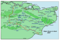
Map showing rivers in Kent
-
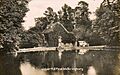
Brattle Mill around 1910
-
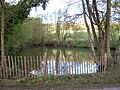
The pond in Swanton Valley
-
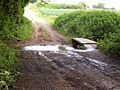
The ford across the stream
