East Malling Stream facts for kids
Quick facts for kids East Malling Stream |
|
|---|---|

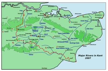
Map of Kent Town Rivers
|
|
| Physical characteristics | |
| Main source | East Malling |
| River mouth | River Medway |
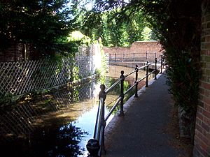
The East Malling Stream, often called "The Stream" by local people, starts at Well Street in East Malling, Kent. It flows mostly towards the east and joins the River Medway at Mill Hall, Aylesford. This stream was very important in the past because it powered six watermills. Some people think the stream might have once been called the Bradbourne, as there's a Bradbourne Lane in Ditton that might be named after it.
Contents
Watermills: Powering the Past
Watermills were like early factories, using the power of flowing water to do work. The Domesday Book, a famous survey from 1086, mentioned two mills in East Malling. By 1363, there were two mills in the village. East Malling also had a fulling mill (used for making cloth) from 1567 to 1719, which was probably Middle Mill. Many of the paper mills along the stream were connected through their owners over time.
Upper Mill, East Malling
51°17′16″N 0°26′05″E / 51.287643°N 0.434611°E Upper Mill became a paper mill by 1764. It was insured for £150 that year. One of its apprentices, Nicholas Tapsfield, later worked at another paper mill. The mill underwent big changes between 1840 and 1860. Sadly, it was pulled down between the First and Second World Wars.
The mill had a pond about 200 meters (200 yards) long. It used an overshot waterwheel that was about 3 meters (10 feet) across and 2.4 meters (8 feet) wide. The remains of this waterwheel were still there in 1972. The water from Upper Mill flowed into the pond of Weir Mill.
Weir Mill, East Malling
51°17′19″N 0°26′10″E / 51.288512°N 0.436091°E Weir Mill was likely one of the two mills mentioned in the Domesday Book. It appeared on a map in 1706. In 1840, it was a water corn mill with a 3.6 meter (12 foot) waterwheel that powered two pairs of millstones. The mill's pond is almost square and covers about a quarter of an acre.
The mill stopped grinding corn in 1930. It was then bought by Whitbread Ltd., a brewing company, who used part of it to store hops. Later, it became a general store. Over time, the wooden parts of the mill buildings started to fall apart.
The Surviving Mill Building
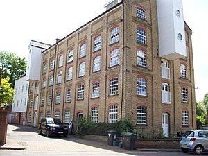
The original part of the mill, covered in timber, dates back to the time of Queen Anne. A brick section was added later, with the last part built in 1889. Around 1893, modern roller mills were installed. A boiler and steam engine were also added, mainly to power the new roller mills, while the waterwheel still drove the old millstones. The steam engine was a special type called a beam engine, which was eventually sold to someone in the USA.
The Wooden Mill
This part of the mill was four stories tall. The bottom was made of brick, and the upper stories were timber. The 3.6 meter (12 foot) waterwheel had eighty buckets and was carried on a 230 mm (9 inch) cast iron axle. This wooden mill could drive three pairs of millstones.
The Brick Mill
This section was built in two parts. It was about six stories high, much taller than the original wooden mill. This part of the mill held six roller mills.
Middle Mill, East Malling
51°17′25″N 0°26′00″E / 51.290369°N 0.433321°E Middle Mill was probably another of the Domesday mills. It existed by 1684. In 1755, Richard Gowlett was making paper here. The mill was sold to George Blunden in 1798. Robert Tassell took over the mill around 1833.
In 1841, the value of the property increased a lot. The mill stood empty from 1848 to 1850. Then, the Busbridge brothers took over. They were involved in a court case in 1859 because of dirty water being discharged from the paper-making process. The mill pond covered about half an acre.
Lower Mill, East Malling
51°17′32″N 0°26′05″E / 51.292136°N 0.434849°E In 1792, a patent was given for using chlorine to bleach rags for paper. It was said that trials had already been done, including by Mr. Larking, who owned Lower Mill at the time. Robert Tassell took over Lower Mill by 1821, making both brown and white papers.
It's thought that Lower Mill stopped making paper regularly in 1848. It was used sometimes until 1851 and then closed completely by 1852. The mill seems to have been pulled down by 1860. The mill pond was about 200 meters (200 yards) long and 45 meters (50 yards) wide, covering nearly 1.5 acres.
Church Mills, Ditton
51°17′50″N 0°27′08″E / 51.297168°N 0.452332°E This was another Domesday site, with one mill recorded in Ditton. It was a corn mill. Many different millers worked here over the years. Robert Foster was the last known miller in 1905. The mill closed around 1912. It is located near a ford (a shallow place to cross a river) in Bradbourne Lane. In its later years, the waterwheel was replaced by a turbine, which is a more modern way to use water power.
Mill Hall Mill, Aylesford
51°18′12″N 0°27′41″E / 51.303276°N 0.461267°E This mill was shown on a map in 1684 and was a paper mill then. Many different owners and millers worked at Mill Hall Mill over the centuries. In 1832, Robert Tassell took over, and it stopped making paper by 1841. It then became a corn mill.
A steam engine was recorded at the mill in 1887, but it was gone by 1890. Henry Packham was the last miller, working there until at least 1913. The mill stopped working by 1922. The machinery was removed, and the building was turned into stables. The mill was pulled down around 1950, but its waterwheel survived until 1969.
The mill building was three stories tall. The bottom part was made of ragstone (a type of local stone), and the upper stories were timber, covered in tarred weatherboarding. The overshot waterwheel was 4.2 meters (14 feet) across and 1.8 meters (6 feet) wide. The last parts of Mill Hall Mill were demolished to make way for the foundations of a footbridge over the M20.
Ford
51°17′40″N 0°27′03″E / 51.294502°N 0.450755°E
As mentioned with Church Mills, there is a ford on Bradbourne Lane. A ford is a place where a river or stream is shallow enough to be crossed by walking or driving through the water.
 | Aaron Henry |
 | T. R. M. Howard |
 | Jesse Jackson |


