Dover Western Heights facts for kids
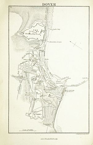
The Western Heights of Dover are an amazing set of old forts in Britain. They are made up of many forts, strong points, and ditches. These were built to protect the country from invaders. They were created in the 1700s and 1800s to make Dover's defenses even stronger. Dover was a very important port, and these forts protected it from attacks by sea and land. By the early 1900s, the Western Heights were known as the strongest and most complex forts in the country. The army left the Heights between 1956 and 1961. Today, this area is a local nature reserve, a special place for nature.
Contents
Building Dover's Defenses
The high ground west of Dover, England, was first protected with earthworks in 1779. This was done to stop a planned invasion that year. The area, now called Dover Western Heights, was properly fortified in 1804. Lieutenant-Colonel William Twiss was asked to update the defenses. This was part of a huge plan to build forts across Britain. It was a response to Napoleon's planned invasion of the United Kingdom. Twiss had already spent years improving the defenses of nearby Dover Castle from 1794 to 1803.
Exploring The Citadel
The Citadel is at the western end of the Heights. It was the main defensive point of the whole area.
The Citadel started as a large fort with strong points, built in the early 1780s. Inside its defenses were three guard houses with narrow openings for shooting.
In 1804, plans were made to rebuild both the Citadel and the Drop Redoubt. They were also to be linked by earthworks along the entire length of the Heights. By 1806, the rebuilt Citadel was surrounded by a defensive ditch. In the middle were temporary barracks huts and the three guardhouses. A well was dug in 1809 to make sure there was always water during a siege. A pumphouse was added in 1860.
Part of the forts collapsed in 1807, so more work was needed to strengthen them. However, when the Napoleonic Wars ended, the Citadel was still not finished. Work only started again in 1853, at the beginning of the Crimean War. At the same time, some existing casemates (bomb-proof rooms) were changed into barracks for 500 soldiers.
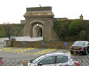
By 1860, you could enter the Citadel by a drawbridge over the ditch. A gate on the eastern side led to a tunnel. This tunnel went through the rampart (a defensive wall) into the fort, past the main guard room.
Between 1860 and 1874, more outer defenses were added. By then, inside the ramparts, the Citadel had barracks, stores, and magazines. These were all built around a large parade ground. The Officers' Quarters and Mess were built by Major William Jervois in 1860. They were designed to be bomb-proof and could even act as a strong tower if the enemy attacked the Citadel.
After 1890, the Citadel was no longer used for defense. Instead, it became a large barracks and a place for soldiers to gather before going to war. Extra huts were added for up to 900 soldiers. In 1956, the Citadel was given to the HM Prison Service. It was then used as a place for young people in custody.
Citadel's Weapons
The Citadel was first planned to have forty-three 18-pounder guns and thirty-one carronades (short, light cannons). By the 1860s, it had been re-armed. It then had eighteen 18-pounder carronades, twenty 12-pounder carronades, and ten 8-inch mortars.
Discovering Drop Redoubt
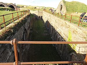
The Drop Redoubt is one of the two main forts on Western Heights. It is connected to the other fort, the Citadel, by a series of dry moats (called the lines). It is one of the most impressive and noticeable parts of Dover’s Western Heights. Before the Redoubt was built, an older fort from the 1700s stood there.
The Redoubt was built in two main periods. The first was from 1804 to 1808, during the Napoleonic Wars. The second was from 1859 to 1864, after new defense plans were made.
First Building Period
The original Drop Redoubt was a simple five-sided shape. It was made by digging trenches into the hillside and lining them with bricks. This made the Redoubt a solid 'island' with barracks, a magazine, and artillery on top. It could hold 200 soldiers at first. But by 1893, the number of soldiers was reduced to just 90.
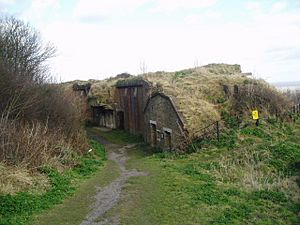
A special part of this first period is the Soldiers’ Quarters. These were five bomb-proof casemates (protected rooms). They had a curved roof shape and were covered with thick earth. This helped them survive mortar-bomb attacks. The windows at the back of each room opened into a trench, which protected them from explosions.
Second Building Period
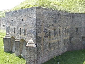
The rise of Napoleon III in the 1850s caused new worries about an invasion. A Royal Commission was set up in 1859 to check Britain's defenses. As a result, more work was needed at the Heights, and the Drop Redoubt was improved. Caponiers (protected passageways) were added to four corners of the fort. Each had a stone staircase leading to the top of the Redoubt. Gunrooms were built next to two of them. These allowed guns to fire along the North and South-East Lines. The original magazine (where ammunition was stored) was made bigger. It was covered with a large earth bank to protect it from mortar fire.
The Officers’ Quarters, Guardroom, and cells were also built during this time. You can tell them apart from the older parts by their semi-circular arches.
During World War II, the Redoubt housed a group of commandos. If an invasion happened, they would have been in charge of destroying Dover Harbour. Their presence was a secret, and the areas around the Redoubt were mined. You can still see signs of their stay, like the sally ports (secret exits) in Caponiers 1 & 2. There is also a short tunnel leading from the surrounding line to Drop Redoubt Road.
The entrance to Drop Redoubt was by a bridge. The inner third of this bridge could pivot. This meant the Redoubt could be cut off from the outside. You can still see the pivot and the space where the bridge swung, but the bridge itself is gone. In the 1980s, the army built a temporary scaffolding bridge for guided tours. But this was removed in the mid-1990s to stop people from entering without permission and causing damage.
Drop Redoubt's Weapons
The Redoubt was originally meant to have 12 smooth-bore 24-pounder guns and two carronades. However, it's unlikely many were installed. The Napoleonic Wars were almost over by the time it was finished. In 1851, it only had three 24-pounders, six 12-pounder saluting guns, and an 8-inch mortar.
After the second building period, eleven Armstrong 64-pounder Rifled Breech Loaders were installed. These guns could move on special carriages. But they didn't work well, so older muzzle-loading guns were used again.
The guns at the Redoubt mostly faced inland. They were meant to attack an invading army trying to capture Dover from the land side.
Earthworks, Strongholds, and Gates
As part of the first rebuilding from 1804, a series of earthworks (ramparts and ditches) were built. These included the North Lines, running along the ridge between the Citadel and Drop Redoubt. The South Lines went from the Citadel down to the Old Folkestone Road. Here, a bridge over the defensive ditch allowed access to the fort and the harbor. The North-East Line ran east from the Drop Redoubt.
While building these defensive lines (1809-16), a layered bulwark called the 'North-West Bastion' was built. It was on the edge of the Citadel, protecting the northern slope of the Heights. At the same time, the 'North-Centre Bastion' was built halfway along the earthworks between the Citadel and Drop Redoubt. As part of the North Lines, a North Entrance was built between the Drop Redoubt and North Centre Bastion. This gave access to the Heights via the North Military Road.
After 1858, another 'Detached Bastion' was built just north of the North Centre Bastion. The North Centre Bastion itself was rebuilt and made stronger. These were designed by Captain Edmund Du Cane. The bastions allowed guns and muskets to fire along the North Line, protecting it. At the same time, the Citadel was made bigger to the west with 'Western Outworks'. More bomb-proof barracks were added within these new ramparts. Also, after the Royal Commission of 1859, the North and South Lines were strengthened. The North-East Line was rebuilt in a different way, better closing off that end of the site between the Drop Redoubt and the cliffs. The North Entrance was also rebuilt and made stronger. You reached it by a winding path through a defensive structure and over lifting bridges across the ditches. A new South Entrance was also built to the south. This was where the South Military Road crossed a new part of the South Lines, near Citadel Road. This large stone gatehouse, also known as Archcliffe Gate, was taken down in the 1960s.
These earthworks not only helped protect the Heights from land attacks. They also enclosed a large area of land between the Citadel and the Redoubt. This area could hold many troops in tents. It was used for large parades and gatherings of soldiers before they left for war during World War I.
Soldiers' Barracks
To add to the soldiers' living spaces in the Redoubt's casemates, construction began in October 1804 on a separate barracks. This was later known as Grand Shaft Barracks. It was designed by Twiss to house 700 men. It was built on land between the Redoubt and the cliff to the south. Near the cliff, the ground was leveled to create a parade ground. Behind it, stepped terraces were made on the hillside. On these, three parallel rows of three- and four-story barracks blocks were built. First, facing the parade ground, were two blocks: one for soldiers and one for officers. Then, on the next terrace up, was a longer block for soldiers plus a small block for Staff Sergeants. Above that, were the Field Officers' quarters. (Later, more terraces held a gymnasium and stables). Steps led up to the terraces from the far left corner of the parade ground. The right side of the parade ground was enclosed by the Officers' Mess. A Canteen (later called 'Regimental Institute') was built facing it, on the left side. The remaining side of the parade ground was left open, giving a clear view across the harbor from the cliff top. Other buildings were placed on more terraces above and beyond the Canteen. More buildings were added in the 1860s, including extra homes for married soldiers.
More barracks were built on Western Heights with the South Front Barracks in the 1860s. These were to the south-west. Unlike the Grand Shaft Barracks, which were seen as vulnerable due to new artillery technology, the South Front Barracks were mostly built inside bomb-proof casemates. These were within the ditch of the southern defensive line, built above Archcliffe Fort. Between these casemated barracks and Citadel Road, homes for married soldiers and other buildings were provided. These were on three stepped terraces built into the hillside. The casemated barracks could house 400 soldiers. The married quarters housed another 120 married soldiers and their families. While the married quarters were still used in the 1900s, by 1912, the casemates were no longer used as barracks. They became offices for the Royal Garrison Artillery.
West of the Grand Shaft Barracks, near the North Gate, several buildings were added in the 1860s. These served the entire Western Heights army. They included a Garrison Chapel and School. A Military Hospital had already been built to the south in 1804-06. It was expanded in the 1860s and later served as a headquarters for the Royal Engineers. These army buildings, along with both the Grand Shaft Barracks and South Front Barracks, were almost completely taken down in the 1960s.
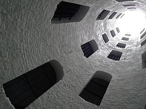
The Grand Shaft Staircase
To help soldiers move between the Heights and the town's defenses and harbor, Twiss suggested building the Grand Shaft in the cliff. It was next to the barracks parade ground. He explained that the new barracks were only about 300 yards from the beach and about 180 feet above the water. But to get to them from the town center on horseback, it was nearly a mile and a half. To walk it was about three-quarters of a mile. All the roads went over ground more than 100 feet above the barracks. The footpaths were very steep and chalky, which could cause accidents in wet weather. So, he recommended building a shaft with a triple staircase. Its main goal was to make it easier and safer for troops. It could also be useful for sending more soldiers or for a safe retreat.
Twiss’s plan was approved, and building began. The shaft was 26 feet wide and 140 feet deep. A 180-foot tunnel connected the bottom of the shaft to Snargate Street. All this cost less than £4000.
The plan involved building two brick-lined shafts, one inside the other. The outer shaft held the triple staircase. The inner shaft acted as a light well, with 'windows' cut in its outer wall to light up the staircases. By March 1805, only 40 feet of the connecting tunnel were left to dig. The project was probably finished by 1807.
Coastal Artillery Batteries
In the 1850s, a gun battery was built on the slope below Drop Redoubt. This was part of Dover's coast artillery defenses. It was called the Drop Battery and had places for eight 8-inch guns. However, within ten years, the building of the North-East Line of fortification blocked some of the battery's firing range. So, in the 1870s, the Drop Battery was replaced by another gun battery further to the south-west: St Martin's Battery. It had three gun emplacements for large 10-inch guns, with ammunition stores between them. In 1898, another gun emplacement, the Citadel Battery, was built at the far end of the Citadel's Western Outworks. It was designed for three powerful 9.2-inch guns. Another battery, South Front Battery, was built at the same time to the south, but it didn't last long. By this time, the guns on St Martin's Battery were old-fashioned. It remained unused until World War II, when it was re-armed with three 6-inch guns. The Citadel Battery, however, stayed in use until Britain's coastal artillery was taken down in 1956.
Ancient Discoveries
The Western Pharos Lighthouse
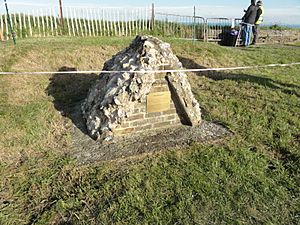
On top of the Redoubt are the remains of a Roman Pharos, or lighthouse. This lighthouse worked with the one that still stands in the grounds of Dover Castle. Both were built in the 2nd Century AD. They would have looked similar and lit up the cliffs on either side of the Roman Port of Dubris. The remains were lost during the first building period but were found again during the second period. They were put back in their original spot as a somewhat shapeless pile of stones. However, the original foundations are still present in the room directly below.
Local people call the remains of the Pharos the ‘Bredenstone’ or the ‘Devil’s Drop of Mortar’. Until 1804, this was where the Lords Warden of the Cinque Ports had their special installation ceremony. It is likely that the name ‘Drop Redoubt’ comes from the local name given to the ruins of the Pharos.
Knights Templar Church Ruins
Between The Citadel and Drop Redoubt are the ruins of an 11th-century church. It has a unique round nave (the main part of the church).
Western Heights Today
Today, much of the site is open as a country park for everyone to enjoy. The old barracks buildings have been taken down.
The Citadel, which was once used for young people in custody, was most recently used as a center for people awaiting immigration decisions. So, it was closed to the public until November 2015, when the center closed. Many of the Citadel's original buildings are still preserved inside. In 2018, the site was put up for sale.
English Heritage owns the Redoubt. The Grand Shaft spiral staircase is owned by the local council. It is opened every year by the Western Heights Preservation Society.
The Grand Shaft Bowl, located south of Drop Redoubt, is the planned location for the new National War Memorial. This memorial will remember, by name, all the soldiers from the British Commonwealth who died in World War I and World War II.
The Grand Shaft Barracks was used for filming the scenes after a nuclear attack in the 1965 film, The War Game, directed by Peter Watkins.
 | Frances Mary Albrier |
 | Whitney Young |
 | Muhammad Ali |


