Petawawa facts for kids
Quick facts for kids
Petawawa
|
|
|---|---|
| Town of Petawawa | |

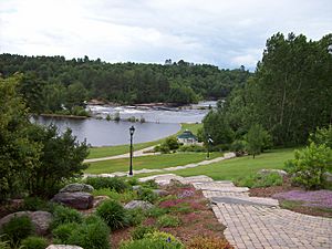
Emerald Necklace Trail and the Petawawa River
|
|
| Country | Canada |
| Province | Ontario |
| County | Renfrew |
| Incorporated (town) | July 1, 1997 |
| Area | |
| • Land | 164.70 km2 (63.59 sq mi) |
| Population
(2021)
|
|
| • Total | 18,160 |
| • Density | 110.3/km2 (286/sq mi) |
| Time zone | UTC-5 (EST) |
| • Summer (DST) | UTC-4 (EDT) |
| Postal code |
K8H
|
Petawawa (pronounced PET-ə-WAW-waw) is a town in the eastern part of Southern Ontario, Canada. It is located in the Ottawa Valley and is the largest town in Renfrew County. In 2021, about 18,160 people lived there.
Contents
A Look at Petawawa's History
The Petawawa area was first home to the Algonquin First Nation. The name Petawawa comes from an Algonquin word, biidaawewe. This word means "where one hears a noise like this." The town's name was once spelled Petewawa. It changed to Petawawa around 1907, possibly because new people moving to the area changed how they said the name.
In the late 1800s, people from Scotland, Ireland, and Germany settled here. The land wasn't great for farming. However, the thick forests were perfect for logging, which means cutting down trees for wood. Petawawa became a township in 1865.
The Canadian military bought land in Petawawa in 1905. This land later became Canadian Forces Base Petawawa. During World War I and World War II, it was used as a camp for POWs, which are prisoners of war. Later, it was home to the Canadian Airborne Regiment. Today, it is one of Canada's biggest army bases. Soldiers from here go on missions around the world to support the United Nations in peacekeeping or other efforts.
In 1961, the main part of Petawawa became its own village. Then, on July 1, 1997, the village and the township joined together. This formed the Town of Petawawa as we know it today.
Petawawa's Geography and Nature
The town of Petawawa sits on the west bank of the Ottawa River. This is where the Petawawa River flows into the Ottawa River. Petawawa is located across the Ottawa River from the Laurentian Mountains. It is also east of Algonquin Park. Because of its location, Petawawa is a popular spot for people who love the outdoors. Many enjoy fishing, hiking, canoeing, and kayaking here.
Besides the main town area, Petawawa also includes smaller communities. These include Black Bay, Kramer Subdivision, Laurentian View, McGuire, Petawawa Point, Pine Meadows, Pine Ridge, Pinehurst Estates, and Riverview.
Petawawa's Climate
Petawawa has a climate with long, cold, and snowy winters. The summers are warm. This type of climate is called a humid continental climate.
| Climate data for Petawawa | |||||||||||||
|---|---|---|---|---|---|---|---|---|---|---|---|---|---|
| Month | Jan | Feb | Mar | Apr | May | Jun | Jul | Aug | Sep | Oct | Nov | Dec | Year |
| Record high humidex | 10.0 | 14.8 | 24.2 | 36.3 | 42.3 | 42.6 | 47.5 | 46.3 | 43.1 | 32.6 | 22.5 | 18.1 | 47.5 |
| Record high °C (°F) | 11.7 (53.1) |
16.5 (61.7) |
24.5 (76.1) |
32.0 (89.6) |
34.0 (93.2) |
36.4 (97.5) |
38.9 (102.0) |
38.9 (102.0) |
35.0 (95.0) |
28.5 (83.3) |
21.7 (71.1) |
15.6 (60.1) |
38.9 (102.0) |
| Mean daily maximum °C (°F) | −6.4 (20.5) |
−4.4 (24.1) |
1.9 (35.4) |
10.8 (51.4) |
19.3 (66.7) |
23.3 (73.9) |
26.3 (79.3) |
24.5 (76.1) |
19.0 (66.2) |
11.9 (53.4) |
4.0 (39.2) |
−3.9 (25.0) |
10.5 (50.9) |
| Daily mean °C (°F) | −12.9 (8.8) |
−11.1 (12.0) |
−4.3 (24.3) |
4.4 (39.9) |
11.9 (53.4) |
16.1 (61.0) |
19.1 (66.4) |
17.6 (63.7) |
12.5 (54.5) |
6.3 (43.3) |
−0.4 (31.3) |
−9.4 (15.1) |
4.1 (39.4) |
| Mean daily minimum °C (°F) | −19.1 (−2.4) |
−17.8 (0.0) |
−10.6 (12.9) |
−2.1 (28.2) |
4.5 (40.1) |
8.9 (48.0) |
11.8 (53.2) |
10.8 (51.4) |
6.0 (42.8) |
0.6 (33.1) |
−4.8 (23.4) |
−14.9 (5.2) |
−2.2 (28.0) |
| Record low °C (°F) | −41.1 (−42.0) |
−39.4 (−38.9) |
−33.8 (−28.8) |
−22.2 (−8.0) |
−9.4 (15.1) |
−2.8 (27.0) |
2.0 (35.6) |
−1.1 (30.0) |
−5.2 (22.6) |
−12.6 (9.3) |
−24.8 (−12.6) |
−37.9 (−36.2) |
−41.1 (−42.0) |
| Record low wind chill | −51.7 | −46.0 | −38.4 | −25.8 | −11.6 | −4.3 | 1.0 | −3.4 | −7.9 | −14.1 | −33.3 | −45.3 | −51.8 |
| Average precipitation mm (inches) | 52.0 (2.05) |
46.4 (1.83) |
60.4 (2.38) |
61.8 (2.43) |
68.5 (2.70) |
81.3 (3.20) |
76.5 (3.01) |
81.1 (3.19) |
79.0 (3.11) |
75.1 (2.96) |
67.2 (2.65) |
67.1 (2.64) |
816.2 (32.13) |
| Average rainfall mm (inches) | 7.6 (0.30) |
9.7 (0.38) |
29.5 (1.16) |
51.3 (2.02) |
67.3 (2.65) |
81.3 (3.20) |
76.5 (3.01) |
81.1 (3.19) |
78.9 (3.11) |
72.1 (2.84) |
46.2 (1.82) |
14.7 (0.58) |
615.9 (24.25) |
| Average snowfall cm (inches) | 53.9 (21.2) |
42.2 (16.6) |
33.9 (13.3) |
11.6 (4.6) |
1.0 (0.4) |
0 (0) |
0 (0) |
0 (0) |
0.1 (0.0) |
3.3 (1.3) |
23.1 (9.1) |
59.5 (23.4) |
228.5 (90.0) |
| Average precipitation days (≥ 0.2 mm) | 16.8 | 12.5 | 13.2 | 11.6 | 11.7 | 12.9 | 11.8 | 12.8 | 14.1 | 13.8 | 15.9 | 18.2 | 165.2 |
| Average rainy days (≥ 0.2 mm) | 2.8 | 2.3 | 6.2 | 9.3 | 11.6 | 12.9 | 11.8 | 12.8 | 14.0 | 12.9 | 10.1 | 4.2 | 110.9 |
| Average snowy days (≥ 0.2 cm) | 16.3 | 12.0 | 9.4 | 3.6 | 0.41 | 0 | 0 | 0 | 0.18 | 1.8 | 8.8 | 16.8 | 69.2 |
| Mean monthly sunshine hours | 93.9 | 124.6 | 145.5 | 179.9 | 230.3 | 246.0 | 276.5 | 240.8 | 150.3 | 120.4 | 67.4 | 66.1 | 1,941.5 |
| Source 1: Environment Canada | |||||||||||||
| Source 2: Environment Canada | |||||||||||||
Petawawa's Population and People
Demographics means information about a population, like how many people live somewhere and how that number changes. In 2021, Petawawa had 18,160 people living in 6,762 homes. This was an increase from its 2016 population of 17,187. The town covers an area of 164.7 square kilometers. This means about 110 people live in each square kilometer.
| Historical populations | |||||||||||||||||||||||||||||||||||||||||||||||||
|---|---|---|---|---|---|---|---|---|---|---|---|---|---|---|---|---|---|---|---|---|---|---|---|---|---|---|---|---|---|---|---|---|---|---|---|---|---|---|---|---|---|---|---|---|---|---|---|---|---|
|
|
||||||||||||||||||||||||||||||||||||||||||||||||
| Before 2001, these numbers were for the Village of Petawawa. From 2001 onwards, they are for the whole Town of Petawawa. | |||||||||||||||||||||||||||||||||||||||||||||||||
It's important to know that before 1961, the population numbers for urban Petawawa were for communities that were still part of the larger Petawawa Township. The Village of Petawawa became its own separate municipality on January 1, 1961.
How Petawawa Makes Money (Economy)
The main employer in Petawawa is the Canadian Government. Most people who live in Petawawa work as civilian employees or as members of the Canadian Forces. They work at CFB Petawawa, which is a large military base. This base is home to the 2 Canadian Mechanized Brigade Group and the 4 Canadian Division Support Group.
Another big employer nearby is Chalk River Laboratories. This is a research facility located in Chalk River.
Getting Around Petawawa (Transportation)
You can reach Petawawa in a few ways. Ontario Highway 17 runs through the town. There is also bus service from Ottawa provided by Ontario Northland Motor Coach Services. The local commercial airport, called Pembroke Airport, is also located in Petawawa.
Famous People from Petawawa
Here are some well-known people who have lived in Petawawa:
- Roy Giesebrecht, a hockey player
- Tom Green, a comedian and actor
- Tommy Mac, a musician
- Lloyd Mohns, a hockey player
- Matthew Peca, a hockey player
- Joe Reekie, a hockey player
- Mike Rowe, a hockey player
- Ray Sheppard, a hockey player
 | James Van Der Zee |
 | Alma Thomas |
 | Ellis Wilson |
 | Margaret Taylor-Burroughs |


