
Petawawa River facts for kids
Quick facts for kids Petawawa River |
|
|---|---|

The dangerous Crooked Chute in Algonquin Provincial Park
|
|

Location of the mouth of the Petawawa River in Ontario
|
|
| Country | Canada |
| Province | Ontario |
| Regions | |
| County/District |
|
| Physical characteristics | |
| Main source | Ralph Bice Lake Geographic township of Butt, Unorganized South Part, Nipissing District 443 m (1,453 ft) 45°40′49″N 78°57′02″W / 45.68028°N 78.95056°W |
| River mouth | Ottawa River Petawawa, Renfrew County 110 m (360 ft) 45°54′38″N 77°15′31″W / 45.91056°N 77.25861°W |
| Length | 187 km (116 mi) |
| Basin features | |
| Progression | Ottawa River→ Saint Lawrence River→ Gulf of Saint Lawrence |
| River system | Ottawa River drainage basin |
| Basin size | 4,200 km2 (1,600 sq mi) |
| Tributaries |
|
The Petawawa River is a cool river in Ontario, Canada. It starts in Algonquin Provincial Park and flows all the way to the Ottawa River near the town of Petawawa. Its name comes from the Algonquian people and means "where one hears a noise like this." This name is perfect because the river has many exciting rapids! It's also special because it's one of only two big rivers that flow completely free into the Ottawa River, meaning no major dams block its path.
Contents
The River's Journey
The Petawawa River begins its adventure at Ralph Bice Lake in the northern part of Algonquin Provincial Park. From there, it flows south to Daisy Lake and then east to Big Trout Lake.
As the river leaves Big Trout Lake, it flows over the Big Trout Lake Dam. It then picks up water from the Tim River and rushes over several rapids like Portal Rapids and Cedar Rapids. Next, it reaches Cedar Lake, where the small community of Brent is located. Here, the Nipissing River joins it.
After Cedar Lake, the river goes over another dam and through a spot called Devil's Chute. It then reaches Radiant Lake, where two more rivers, the North River and the Little Madawaska River, add their waters. The Petawawa River continues its journey, passing through many more rapids, including Squirrel Rapids and White Horse Rapids. It also picks up the Crow River.
The river then flows past the Algonquin Radio Observatory and into Lake Travers. After this, the Petawawa River enters a canyon, where it crashes through even more rapids like Big Thompson Rapids and the famous Crooked Chute. It eventually reaches Whitson Lake near the Petawawa Hills.
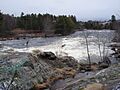
Leaving Algonquin Provincial Park, the river enters Renfrew County. It flows past CFB Petawawa, a Canadian Forces military base, and through more rapids like Race Horse Rapids. Finally, it reaches Lac du Bois Dur, where the Barron River joins it. The river then enters the town of Petawawa, flows under Ontario Highway 17, and empties into Black Bay on the Ottawa River.
The Petawawa River is about 187 kilometres (116 mi) long. It drains an area of about 4,200 square kilometres (1,600 sq mi), which is like a giant funnel collecting water. On average, about 45 cubic metres (1,589 cu ft) of water flows through it every second!
River Activities and History
For many years, from the late 1800s until the 1960s, the Petawawa River was used to float cut timber downriver. This was a common way to transport wood from forests to sawmills back then.
Today, the river is a popular spot for people who love canoeing and kayaking. They come to enjoy both its exciting white water rapids and the beautiful views of nature.
There were plans to build a power station on the river at Big Eddy Rapids. This station would have used the river's flow to create electricity. However, many local people, paddlers, and environmental groups were against the project. They worried it would harm the river's natural beauty and the rapids that people love. Because of this opposition, the plans for the power station were stopped in 2015.
River Features
Part of the Petawawa River flows through a special geological area called the Ottawa-Bonnechere Graben. This is a very old rift valley that formed about 175 million years ago. It's like a giant crack in the Earth's surface!
Rivers Joining the Petawawa
Many smaller rivers and creeks flow into the Petawawa River along its journey. These are called tributaries. Here are some of the main ones, listed from the mouth of the river back upstream:
- Barron River (joins from the right side)
- Crow River (joins from the right side)
- Little Madawaska River (joins from the right side)
- North River (joins from the left side)
- Nipissing River (joins from the left side)
- Tim River (joins from the left side)
Images for kids
-
The river as it runs through the town of Petawawa

See also
 In Spanish: Río Petawawa para niños
