Ottawa-Bonnechere Graben facts for kids
Quick facts for kids Ottawa-Bonnechere Graben |
|
|---|---|

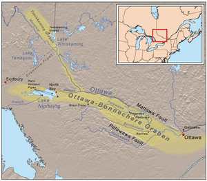
Map of the Ottawa-Bonnechere and Timiskaming grabens
|
|
| Location | Ontario and Quebec, Canada |
| Part of | Saint Lawrence rift system |
| Length | 700 km (435 mi) |
| Geology | Graben |
| Age | Late Proterozoic to Early Paleozoic |
The Ottawa-Bonnechere Graben (also called the Ottawa Graben) is a special geological area. It looks like a long, wide ditch in the Earth. This "ditch" is about 55 km (34 mi) wide. It stretches from near Montreal all the way through Ottawa.
This graben is part of a bigger system of valleys called the Saint Lawrence rift system. A rift valley forms when the Earth's crust sinks down between two large cracks, or fault zones. In this case, the land dropped about a kilometre between the Mattawa and Petawawa faults.
Contents
Exploring the Ottawa-Bonnechere Graben
The Ottawa-Bonnechere Graben is very long, about 700 km (435 mi). It starts near Montreal in the east and goes west towards Greater Sudbury and Lake Nipissing. In the east, it connects with the Saint Lawrence rift system. This system is like a giant crack that runs for over 1000 km along the Saint Lawrence River valley.
How the Graben Formed
The part of the graben west of Ottawa was the first to be identified. Scientists have since traced it all the way to Lake Nipissing. It also branches off towards Lake Timiskaming and the Montreal River valley. This branch is known as the Timiskaming Graben.
Geologists believe this graben formed a very long time ago. It was a "failed arm" of an ancient ocean called the Iapetus Ocean. This ocean existed before the Atlantic Ocean we know today. The main Ottawa-Bonnechere Graben formed about 452 million years ago. The Timiskaming Graben formed a bit later, around 449–451 million years ago. These valleys became active again about 150 million years ago. This happened when the supercontinent Pangaea started to break apart.
Understanding the Graben's Geology

Over millions of years, erosion has worn away the surface of the Earth in this region. This has revealed many interesting geological features. These include old volcanic pipes, which are like the "throats" of ancient volcanoes. You can see examples at Callander Bay and the Manitou Islands in Lake Nipissing.
Underground Rock Formations
Other features exposed by erosion are Batholiths and dikes. These are large bodies of igneous rock that formed deep underground. Examples include the Timber Lake, Mulock, and West Arm batholiths.
There was also some volcanic activity in the Mesozoic era. This included kimberlites forming during the Jurassic period. Kimberlites are special rocks that sometimes contain diamonds. Later, in the early Cretaceous period, more volcanic activity happened along the eastern part of the graben.
The Monteregian Hills
The Monteregian Hills in Montérégie, Quebec, are a result of this later volcanic activity. These hills are thought to have formed when the North American Plate moved over a "hotspot." A hotspot is a place where hot magma rises from deep within the Earth. The Monteregian Hills are the eroded remains of these underground rock formations.
Scientists believe these formations were either the "feeders" for ancient extinct volcanoes, or they were intrusions that never reached the surface. Mont Saint-Hilaire is especially famous for its rare mineral specimens.
Natural Beauty and a Crater
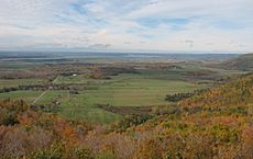
Along the northern side of the Ottawa-Bonnechere Graben, there is a dramatic steep slope called an escarpment. This is the southern edge of the Gatineau Hills. This Eardley Escarpment is popular for rock climbers and hikers. It offers amazing views of the flat fields below, which stretch to the Ottawa River.
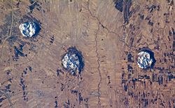
Near a branch of the Ottawa-Bonnechere Graben, you can find the Brent impact crater. This crater is about 3.8 km (2.4 mi) wide. It was formed about 400 million years ago when a giant meteorite crashed into the Earth.
Scientists first spotted the Brent crater in 1951 from aerial photos. Studies show it's about 425 m (1,390 ft) deep, but it's partly filled with sedimentary rocks. The impact was incredibly powerful, like 250 megatons of TNT exploding! At the time, this area was probably covered by a shallow sea.
History and Transportation Routes
After the last Ice Age, the low areas created by the graben became pathways for water flowing from the Great Lakes. Later, these natural pathways became important routes for explorers and traders.
Waterways for Trade
Today, the Ottawa River and its tributary, the Mattawa River, flow through these valleys. The Mattawa River connects to Trout Lake near Lake Nipissing. From Lake Nipissing, the French River flows into Lake Huron. This water route was much shorter than going through the lower Great Lakes.
It was a main route for French-Canadian voyageurs during the fur trade. They used canoes to travel from Montreal to the upper Great Lakes. The valleys of the Ottawa and Montreal Rivers were also part of a route to James Bay.
Modern Transportation
Today, these valleys are still used for transportation. The Canadian Pacific Railway and the Trans-Canada Highway now follow these historic paths.
The Mattawa River was especially important for native peoples and fur traders. Canoes would turn left from the Ottawa River into the Mattawa. They would then reach Lake Nipissing by using "La Vase Portage," an 11 km (7 mi) stretch of water and portages.
In the 1800s, the river helped access large forests of white pine trees. It was also used to float logs to sawmills. While logging is still important, most of the Mattawa River is now a Canadian Heritage River. This means its shores are protected from further development. Today, the river and its lakes are mainly used for fun activities like boating and fishing.
 | Charles R. Drew |
 | Benjamin Banneker |
 | Jane C. Wright |
 | Roger Arliner Young |


