
Manitoba Highway 1 facts for kids
Quick facts for kids Highway 1 |
||||
|---|---|---|---|---|
| Trans-Canada Highway | ||||
|
PTH 1 highlighted in red.
|
||||
| Route information | ||||
| Maintained by Manitoba Infrastructure | ||||
| Length | 488.8 km (303.7 mi) | |||
| Existed | 1942–present | |||
| Major junctions | ||||
| West end | Saskatchewan border near Kirkella continues west as |
|||
| East end | Ontario border near West Hawk Lake continues east as |
|||
| Location | ||||
| Districts: |
|
|||
| Rural municipalities: |
|
|||
| Major cities: | ||||
| Towns: |
|
|||
| Highway system | ||||
Manitoba provincial highways
|
||||
Manitoba Highway 1 is a very important road in Manitoba, Canada. It is part of the much larger Trans-Canada Highway system. This highway runs all the way across Manitoba from west to east. It is about 490 kilometers (304 miles) long. The highway starts at the Saskatchewan border near a place called Kirkella, Manitoba. It then connects to Saskatchewan Highway 1. The main city it goes through is Winnipeg, which is Manitoba's capital. The highway finishes at the Ontario border near West Hawk Lake. There, it changes its name to Ontario Highway 17.
Contents
What is the Trans-Canada Highway?
The Trans-Canada Highway is a huge road system. It connects all ten provinces of Canada. It is one of the longest national highways in the world. Manitoba Highway 1 is a key part of this big road. It helps people travel across Canada.
Connecting the Country
This highway helps link different parts of Canada. It makes it easier for people to visit other provinces. It also helps move goods and supplies across the country. Think of it as a super important pathway for Canada.
Where Does Manitoba Highway 1 Go?
Manitoba Highway 1 crosses the entire province. It starts in the west and ends in the east.
Journey from West to East
- Starting Point: The highway begins at the Saskatchewan border. This is near the small community of Kirkella, Manitoba.
- Passing Through Towns: As you drive east, the highway goes through or near several towns. These include Virden and Carberry.
- Major Cities: The biggest city on the route is Winnipeg. This is the capital of Manitoba. The highway helps people get into and out of Winnipeg.
- Ending Point: The highway finishes at the Ontario border. This is close to West Hawk Lake, a popular spot. From there, the road continues into Ontario.
Important Connections
Along its path, Highway 1 connects with many other roads. These connections help drivers reach other parts of Manitoba. For example, it meets Manitoba Highway 10 in Brandon. It also connects with Manitoba Highway 16 near Portage la Prairie. These links are vital for travel and trade.
History of the Highway
Manitoba Highway 1 has been around for a long time. It was officially established in 1942. Over the years, it has been improved. This helps make travel safer and faster.
Building the Road
Building a highway this long takes a lot of work. It involves many engineers and construction workers. They built bridges and paved the road. This made it possible for cars and trucks to travel easily.
Who Maintains the Highway?
The highway is looked after by Manitoba Infrastructure. This government department makes sure the road is in good shape. They fix potholes and clear snow. This keeps the highway safe for everyone.
Images for kids
-
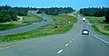
Eastbound on the Trans Canada Highway near Carberry.
-
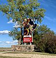
The "Manitoba Welcome/Bienvenue" sign at the Saskatchewan border.


