Ishpatina Ridge facts for kids
Quick facts for kids Ishpatina Ridge |
|
|---|---|
| Highest point | |
| Elevation | 693 m (2,274 ft) |
| Prominence | 394 m (1,293 ft) |
| Geography | |
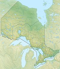
| Location | 90 km north of Sudbury, Ontario in Ellis Township, Sudbury District |
| Parent range | Canadian Shield, unnamed range |
| Topo map | NTS 041P07 |
| Climbing | |
| Easiest route | Hike |
Ishpatina Ridge is the highest natural point in the Canadian province of Ontario. It stands about 693 meters (2,274 feet) above sea level. For a long time, people thought another mountain, Maple Mountain, was the highest. But in the 1970s, new maps showed that Ishpatina Ridge was actually taller.
Contents
Ishpatina Ridge: Ontario's Highest Point
Ishpatina Ridge rises about 300 meters (984 feet) above the land around it. It is located in Lady Evelyn-Smoothwater Provincial Park. Because it is so far away, reaching Ishpatina Ridge can be a real adventure.
Getting to Ishpatina Ridge
The closest main road, Highway 560, is over 30 kilometers (18 miles) to the north. There are some logging roads and trails in the area. However, they can be hard to travel on, especially in bad weather.
The most common way to get to Ishpatina Ridge is by canoe and portage. This route starts from a logging road south of Capreol. Capreol is a town north of Sudbury. Another route exists from Gowganda, which is the nearest community. This northern route has many portages, making it very difficult. People have traditionally used this route in winter for skiing or snowshoeing.
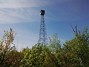
In the past, forest workers used to staff a fire tower on the ridge. They would often travel to the site by float plane.
What Does "Ishpatina" Mean?
The name "Ishpatina" comes from the Ojibwe language. The Ojibwe word ishpadinaa means "high place" or "ridge." Other places also get their names from this same word. For example, Spadina Avenue in Toronto and the city of Ishpeming, Michigan are named this way.
The Old Fire Tower
An old firetower, known as the Ellis Tower, still stands on the highest part of the Ridge. The first tower was 80 feet (24 meters) tall and was built in 1930. The tower standing today is 100 feet (30 meters) high. It was left empty in the 1960s.
The towerman who worked there lived in a cabin by Scarecrow Lake. Each day, they would hike a 3.5-kilometer (2.2-mile) trail to the top. This hike took about two hours to go up and a little over an hour to come back down.
The Deep Ishpatina Canyon
Between Tower Peak and the North Peak, you can find the Ishpatina Canyon. This is one of the deepest canyons in Ontario. Tower Peak is 2,274 feet (693 meters) high. The bottom of the canyon is at 1,750 feet (533 meters) above sea level. The North Peak is 2,250 feet (686 meters) high.
The canyon is almost twice as deep as Ouimet Canyon. Ouimet Canyon is often thought of as Ontario's deepest. However, the sides of Ishpatina Canyon slope down more gently. This makes it harder to see how deep it truly is.
The Ishpatina Ridge was also shown in an online series called The Peakbaggers.
See also
 In Spanish: Ishpatina Ridge para niños
 | Anna J. Cooper |
 | Mary McLeod Bethune |
 | Lillie Mae Bradford |


