Mantoloking, New Jersey facts for kids
Quick facts for kids
Mantoloking, New Jersey
|
||
|---|---|---|
|
Borough
|
||
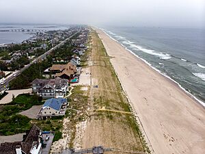
Aerial view above Mantoloking
|
||
|
||
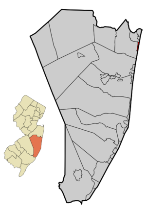
Location of Mantoloking in Ocean County highlighted in red (right). Inset map: Location of Ocean County in New Jersey highlighted in orange (left).
|
||
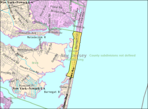
Census Bureau map of Mantoloking, New Jersey
|
||
| Country | ||
| State | ||
| County | ||
| Incorporated | April 10, 1911 | |
| Government | ||
| • Type | Borough | |
| • Body | Borough Council | |
| Area | ||
| • Total | 0.64 sq mi (1.66 km2) | |
| • Land | 0.39 sq mi (1.00 km2) | |
| • Water | 0.25 sq mi (0.66 km2) 39.69% | |
| Area rank | 533rd of 565 in state 31st of 33 in county |
|
| Elevation | 0 ft (0 m) | |
| Population
(2020)
|
||
| • Total | 331 | |
| • Estimate
(2023)
|
332 | |
| • Rank | 559th of 565 in state 33rd of 33 in county |
|
| • Density | 857.0/sq mi (330.9/km2) | |
| • Density rank | 401st of 565 in state 21st of 33 in county |
|
| Time zone | UTC−05:00 (Eastern (EST)) | |
| • Summer (DST) | UTC−04:00 (Eastern (EDT)) | |
| ZIP Code |
08738
|
|
| Area code(s) | 732 | |
| FIPS code | 3402943380 | |
| GNIS feature ID | 0885290 | |
Mantoloking is a small coastal town, called a borough, in Ocean County, New Jersey. It's known for being a beautiful spot along the Jersey Shore. In 2020, about 331 people lived there. However, during the summer, the population grows to around 5,000 people!
Mantoloking is a very wealthy community. In 1999, it had the highest income per person in New Jersey. In 2012, Forbes magazine listed it as one of "America's Most Expensive ZIP Codes." This means homes there are quite pricey.
The town became an official borough on April 10, 1911. Its name, Mantoloking, comes from the Unami language of the Lenni Lenape Native Americans. They used to live in New Jersey. The name might mean "frog ground" or "sand place."
Mantoloking is located on the Barnegat Peninsula, which is a long, narrow barrier island. This island separates Barnegat Bay from the Atlantic Ocean. A bridge, the Mantoloking Bridge, connects the town to the mainland. This bridge links Mantoloking with Brick Township across the bay. The town is also home to the Mantoloking Yacht Club, which has produced Olympic champions! Some old summer homes in Mantoloking were designed by a famous architect named Stanford White. Mantoloking and its neighbor, Bay Head, are often called the "Gold Coast" of the Jersey Shore. It's also a "dry town," meaning you can't buy alcohol there.
Contents
What is the History of Mantoloking?
How Did Hurricane Sandy Affect Mantoloking?
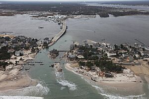
In 2012, Hurricane Sandy caused a lot of damage to Mantoloking. About 90% of the homes were harmed by the huge storm surge. The biggest damage happened when the ocean broke through the barrier island. This created a new opening between the Barnegat Bay and the Atlantic Ocean.
When Hurricane Sandy hit New Jersey on October 29, 2012, Mantoloking was one of the hardest-hit areas. More than 50 homes had to be torn down. This was nearly 10% of all the homes in the borough. After the storm, Verizon Communications decided not to rebuild traditional phone lines for residents. Instead, they offered a wireless phone service. This caused protests from groups like the AARP, as residents worried about call quality and emergency services.
Where is Mantoloking Located?
Mantoloking is a small town, covering about 0.64 square miles (1.66 km2). A good part of this area, about 0.25 square miles (0.66 km2), is water.
The borough shares borders with other towns in Ocean County. These include Bay Head, Brick Township, and Point Pleasant.
What is Mantoloking's Population?
| Historical population | |||
|---|---|---|---|
| Census | Pop. | %± | |
| 1920 | 37 | — | |
| 1930 | 37 | 0.0% | |
| 1940 | 58 | 56.8% | |
| 1950 | 72 | 24.1% | |
| 1960 | 160 | 122.2% | |
| 1970 | 319 | 99.4% | |
| 1980 | 433 | 35.7% | |
| 1990 | 334 | −22.9% | |
| 2000 | 423 | 26.6% | |
| 2010 | 296 | −30.0% | |
| 2020 | 331 | 11.8% | |
| 2023 (est.) | 332 | 12.2% | |
| Population sources: 1920–2000 1920 1920–1930 1940–2000 2000 2010 2020 |
|||
In 2010, there were 296 people living in Mantoloking. There were 162 households, with 103 of them being families. The average household had about 1.77 people.
Most of the people living in Mantoloking were White (94.93%). A small number were Black or African American (1.69%), Native American (0.34%), or Asian (0.34%). About 2.36% of the population was Hispanic or Latino.
The town has many older residents. About 47.6% of the population was 65 years old or older. The median age was 64.4 years. This means half the people were older than 64.4 and half were younger.
What Schools Do Mantoloking Students Attend?
Students from Mantoloking go to public schools in Point Pleasant Beach. This is part of a special agreement between the towns. Students attend school from kindergarten all the way through twelfth grade. Students from Bay Head and Lavallette also attend the high school in Point Pleasant Beach.
The school district has two schools. G. Harold Antrim Elementary School serves students from Pre-K to 8th grade. Point Pleasant Beach High School is for students in grades 9-12. In the 2018–19 school year, there were 763 students in the district. There were also 78.3 teachers, meaning about 9.7 students for every teacher.
How Do People Travel in Mantoloking?
As of 2010, Mantoloking had about 6.42 miles of roads. Most of these roads, about 4.00 miles, are cared for by the town itself.
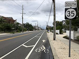
The main roads in Mantoloking are New Jersey Route 35 and County Route 528. Route 35 runs north to south, parallel to the ocean. County Route 528 starts at Route 35 and goes west across Barnegat Bay to the mainland.
Is There Public Transportation?
Yes, you can use public transportation near Mantoloking. NJ Transit trains stop at the Bay Head station, which is about 1.5 miles north of Mantoloking. From there, you can take the North Jersey Coast Line train. It goes north to Penn Station Newark and Penn Station New York in Midtown Manhattan.
What is the Climate Like in Mantoloking?
Mantoloking has a humid subtropical climate. This means it has hot, humid summers and mild winters. In the summer, a cool sea breeze often blows in the afternoon. However, it can get very hot and humid sometimes.
In winter, it can get very cold and windy. The average snowfall from November to April is about 18 to 24 inches. February is usually the snowiest month. This is when "nor'easter" storms, which bring heavy snow and strong winds, are most common.
| Climate data for Mantoloking Beach, NJ (1981–2010 Averages) | |||||||||||||
|---|---|---|---|---|---|---|---|---|---|---|---|---|---|
| Month | Jan | Feb | Mar | Apr | May | Jun | Jul | Aug | Sep | Oct | Nov | Dec | Year |
| Mean daily maximum °F (°C) | 40.2 (4.6) |
42.7 (5.9) |
49.4 (9.7) |
59.1 (15.1) |
68.7 (20.4) |
78.0 (25.6) |
83.2 (28.4) |
82.0 (27.8) |
75.9 (24.4) |
65.3 (18.5) |
55.2 (12.9) |
45.0 (7.2) |
62.1 (16.7) |
| Daily mean °F (°C) | 32.6 (0.3) |
34.7 (1.5) |
41.0 (5.0) |
50.4 (10.2) |
60.1 (15.6) |
69.5 (20.8) |
74.9 (23.8) |
73.9 (23.3) |
67.3 (19.6) |
56.2 (13.4) |
47.0 (8.3) |
37.3 (2.9) |
53.8 (12.1) |
| Mean daily minimum °F (°C) | 25.0 (−3.9) |
26.6 (−3.0) |
32.7 (0.4) |
41.7 (5.4) |
51.4 (10.8) |
61.1 (16.2) |
66.7 (19.3) |
65.8 (18.8) |
58.6 (14.8) |
47.0 (8.3) |
38.7 (3.7) |
29.6 (−1.3) |
45.5 (7.5) |
| Average precipitation inches (mm) | 3.66 (93) |
3.08 (78) |
4.20 (107) |
3.96 (101) |
3.51 (89) |
3.68 (93) |
4.65 (118) |
4.46 (113) |
3.49 (89) |
3.75 (95) |
3.94 (100) |
3.99 (101) |
46.37 (1,178) |
| Average relative humidity (%) | 64.9 | 62.5 | 60.8 | 62.3 | 65.7 | 70.3 | 69.9 | 71.5 | 71.3 | 69.9 | 68.0 | 66.3 | 67.0 |
| Average dew point °F (°C) | 22.1 (−5.5) |
23.2 (−4.9) |
28.5 (−1.9) |
38.0 (3.3) |
48.6 (9.2) |
59.4 (15.2) |
64.4 (18.0) |
64.1 (17.8) |
57.7 (14.3) |
46.5 (8.1) |
37.0 (2.8) |
27.1 (−2.7) |
43.1 (6.2) |
| Source: PRISM | |||||||||||||
| Climate data for Sandy Hook, NJ Ocean Water Temperature (30 N Mantoloking) | |||||||||||||
|---|---|---|---|---|---|---|---|---|---|---|---|---|---|
| Month | Jan | Feb | Mar | Apr | May | Jun | Jul | Aug | Sep | Oct | Nov | Dec | Year |
| Daily mean °F (°C) | 37 (3) |
36 (2) |
40 (4) |
46 (8) |
55 (13) |
62 (17) |
69 (21) |
72 (22) |
68 (20) |
59 (15) |
51 (11) |
43 (6) |
53 (12) |
| Source: NOAA | |||||||||||||
Who are Some Famous People from Mantoloking?
Many interesting people have lived in or had strong connections to Mantoloking:
- Britton Chance (1913–2010) was a professor and an Olympic gold medalist in sailing in 1952. He won with fellow Mantoloking sailors, Edgar White and his twin brother Sumner.
- Britton Chance Jr. (1940–2012) was a yacht designer.
- Donald DiFrancesco (born 1944) used to be the acting governor of New Jersey. He spends his summers here.
- James Gandolfini (1961–2013) was a famous actor. He spent his childhood summers in Mantoloking and continued to do so as an adult.
- Laura Barney Harding (1902–1992) was a close friend of actress Katharine Hepburn. Laura owned a summer home on the oceanfront in Mantoloking.
- Richard Nixon (1913–1994), who later became a U.S. president, spent summers here when he was vice president.
- Jan O'Malley (born 1946) is a sailor who was named US Sailor of the Year three times.
- Edgar White (1929–2014) and Sumner White (1929–1988) were twin brothers and Olympic champion sailors. They won gold medals in 1952 with Britton Chance.
See also
 In Spanish: Mantoloking para niños
 | Janet Taylor Pickett |
 | Synthia Saint James |
 | Howardena Pindell |
 | Faith Ringgold |


