Rainband facts for kids

A rainband is a long, narrow area of rain. It's like a long line or band of clouds and rain. These bands can be calm and spread out (stratiform) or stormy with lots of action (convective). They form because of different temperatures in the air.
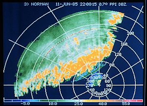
When you see a rainband on a weather radar, it looks like a long, thin shape. In a tropical cyclone (like a hurricane or tropical storm), rainbands curve and spiral around the center. These bands bring rain showers and thunderstorms. If they include the calm eye and the stormy eyewall, they are part of a hurricane. The size of these rainbands can even help scientists figure out how strong a cyclone is.
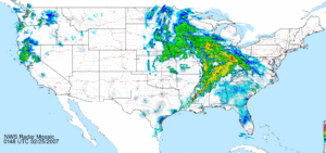
Rainbands can also form near cold fronts. Sometimes, these turn into squall lines, which are lines of strong thunderstorms that can even cause tornadoes. Mountains can change how these rainbands look by blocking winds. Also, when sea breezes and land breezes meet, they can create bands of thunderstorms if there's enough moisture.
Contents
What are Rainbands?
Rainbands are basically lines of rain. They are caused by differences in air temperature. Think of it like different air masses pushing against each other. This push creates a long, narrow zone where rain falls.
How Rainbands Form
- Temperature Differences: When warm, moist air meets cooler, drier air, the warm air rises. This rising air cools and forms clouds and rain in a line.
- Wind Patterns: Winds can also shape rain into long bands. This is especially true around big storm systems.
- Moisture: You need enough moisture in the air for rainbands to form.
Rainbands in Different Storms
Rainbands are a key part of many weather systems. They can look different depending on the type of storm.
Extratropical Cyclones
Extratropical cyclones are large storm systems that form outside of the tropics.
- Ahead of Fronts: Rainbands that form ahead of warm fronts usually have steady, widespread rain. They don't have much strong upward air movement.
- Strong Cold Fronts: In areas with lots of moisture and strong winds, narrow, stormy rainbands can form. These are often squall lines, found ahead of strong cold fronts. They can bring heavy rain and strong winds.
- Behind Cold Fronts: Wider rainbands can form behind cold fronts. These usually have more steady rain and less stormy activity.
- Snow Bands: In very cold storms, narrow bands of heavy snow can form. These bands are about 20 to 50 kilometers (12 to 31 miles) wide. They happen where there are big temperature changes.
- Lake Effect Snow: When cold air from an extratropical cyclone moves over warmer bodies of water, like the Great Lakes, it can create narrow snow bands. These can cause very heavy snow in small areas.
Tropical Cyclones

Tropical cyclones are powerful storms like hurricanes and tropical storms.
- Spiraling In: Rainbands in tropical cyclones are found on the edges and spiral inward toward the storm's center. They need moisture and a cooler air pocket to form.
- Outward Moving Bands: Some rainbands, about 80 to 150 kilometers (50 to 93 miles) from the center, move outward. They can bring heavy rains, strong winds (squalls), and even tornadoes.
- New Eyewalls: Sometimes, in very strong hurricanes, some rainbands move closer to the center and form a second, outer eyewall.
- Measuring Storm Strength: These spiral rainbands are so important that scientists use them to figure out how strong a tropical cyclone is. The Dvorak technique uses satellite images of these bands and temperature differences to estimate a storm's wind speed and central pressure.
Rainbands Shaped by Land
Geography, like mountains or coastlines, can also influence where and how rainbands form.
- Mountains: Convective rainbands can form parallel to mountains on the side where the wind hits them. This happens because of air waves caused by hills.
- Barrier Jets: When rainbands near weather fronts get close to steep mountains, a low-level "barrier jet" of wind forms. This wind runs parallel to the mountain ridge and can slow down the rainband.
- Sea and Land Breezes: If there's enough moisture, sea breeze and land breeze fronts can create stormy rainbands. Sometimes, these sea breeze thunderstorm lines can become so strong that they hide where an approaching cold front is located.
- Ocean Currents: The edges of ocean currents can cause thunderstorm bands. This is due to temperature differences where the currents meet.
- Islands: Downwind of islands, rainbands can form when low-level winds meet after flowing around the island's edges. This has been seen off the coast of California after cold fronts pass.


