
Dvorak technique facts for kids
The Dvorak technique is a clever way to figure out how strong a tropical cyclone (like a hurricane or typhoon) is. It was created in 1974 by Vernon Dvorak. This method uses only pictures from satellites, both regular ones you can see (visible) and ones that detect heat (infrared).
Many important weather groups use the Dvorak technique to estimate how powerful cyclones are. These include the National Hurricane Center (TAFB), NOAA's Satellite Analysis Branch (SAB), the Joint Typhoon Warning Center in Pearl Harbor, Hawaii, and the Air Force Weather Agency (AFWA).
Contents
What is the Dvorak Technique?
The Dvorak technique helps scientists guess a tropical cyclone's strength by looking at its shape and how it looks on satellite images. It's like a puzzle where different cloud patterns tell you how strong the storm is. This method is very useful because it doesn't need special tools inside the storm.
How Does It Work?
Scientists look at satellite pictures of the storm. They check for certain features, like the shape of the storm's eye (the center) or how the clouds are arranged around it. For example, a very clear, round eye usually means a very strong storm. Different patterns are given a "Dvorak number," which tells you the storm's estimated intensity.
Looking at Cloud Patterns
The Dvorak technique uses different cloud patterns to figure out a storm's strength.
- Central Dense Overcast (CDO): This is a large, round area of very cold, high clouds that covers the storm's center. A very round and dense CDO often means a strong storm.
- Eye Feature: If the storm has a clear eye, its size and how well-defined it is can tell you a lot. A small, clear eye usually means a very intense storm.
- Banding Features: These are spiral bands of clouds that wrap around the storm's center. How tightly they wrap and how organized they are also help estimate strength.
Dvorak Numbers Explained
The Dvorak technique gives each storm a "T-number" (T for Tropical). These numbers range from T1.0 (weakest) to T8.0 (strongest). Each T-number matches a certain estimated wind speed and pressure inside the storm. For example, a T4.0 storm is stronger than a T3.0 storm.
Why Is the Dvorak Technique Important?
The Dvorak technique is super important for tracking tropical cyclones. It helps forecasters understand how strong a storm is and if it's getting stronger or weaker. This information helps people on land prepare for storms and stay safe. It's especially useful when there are no special aircraft flying into the storm to measure its strength directly.
Who Uses This Technique?
Many weather centers around the world use the Dvorak technique. They use it to give official estimates of cyclone strength. This helps ships, planes, and people living in coastal areas know what to expect from a storm.
Images for kids
-
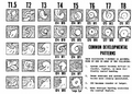
Common patterns seen as tropical cyclones grow, with their Dvorak intensity numbers.
-
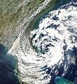
The Dvorak technique works best for tropical cyclones, not for storms like Subtropical Storm Andrea which was a subtropical storm.
-
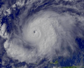
Satellite image of Typhoon Haiyan at T8.0, showing its very strong intensity.
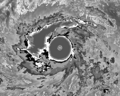
-
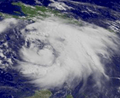
Tropical Storm Wilma when it was at T3.0.
-
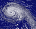
Tropical Storm Dennis when it was at T4.0.
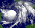
-
Hurricane Jeanne when it was at T5.0.
-
Hurricane Emily when it was at T6.0.


