New Seabury, Massachusetts facts for kids
Quick facts for kids
New Seabury, Massachusetts
|
|
|---|---|

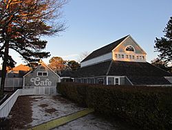
Popponesset Marketplace
|
|

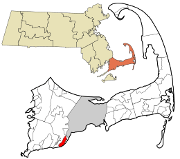
Location in Barnstable County and the state of Massachusetts.
|
|
| Country | United States |
| State | Massachusetts |
| County | Barnstable |
| Town | Mashpee |
| Area | |
| • Total | 2.58 sq mi (6.67 km2) |
| • Land | 2.41 sq mi (6.24 km2) |
| • Water | 0.17 sq mi (0.43 km2) |
| Elevation | 26 ft (8 m) |
| Population
(2020)
|
|
| • Total | 852 |
| • Density | 353.67/sq mi (136.53/km2) |
| Time zone | UTC-5 (Eastern (EST)) |
| • Summer (DST) | UTC-4 (EDT) |
| ZIP code |
02649
|
| Area code(s) | 508 |
| FIPS code | 25-45500 |
| GNIS feature ID | 1877297 |
New Seabury is a special area in the town of Mashpee. It is located in Barnstable County, Massachusetts, on Cape Cod. The United States government counts the population of this area separately.
Many people have summer homes here. New Seabury also has fun places like a country club. You can also find beautiful neighborhoods like Fells Pond, Daniels Island, and Littleneck Bay. In 2020, about 852 people lived in New Seabury. This community is built on the historic land of the Wampanoag Native American people.
Contents
New Seabury's Native American Roots
New Seabury grew a lot in the 1960s and 1970s. During this time, many people wanted vacation homes in coastal areas of New England. Before this growth, the land was mostly home to the Wampanoag people. They believed land was for everyone to share.
As more vacation homes were built, the area changed. Newcomers started to control the local government. They also put up barriers to lands the Wampanoag people had used for many years. One big example was the New Seabury condominium complex built along the coast.
Where is New Seabury?
New Seabury is in the southern part of the town of Mashpee. It is located at 41°34′23″N 70°28′27″W / 41.573090°N 70.474038°W. To the south, it touches Vineyard Sound and Nantucket Sound. To the east, you'll find the areas of Popponesset and Popponesset Island.
Ockway Bay is to the north of New Seabury. To the west is Great Oak Road. A small part of New Seabury goes past Great Oak Road. It stretches west to the Great River, across from Monomoscoy Island.
The United States Census Bureau says New Seabury covers about 6.6 square kilometers (2.58 square miles). Most of this area, about 6.2 square kilometers (2.41 square miles), is land. The rest, about 0.4 square kilometers (0.17 square miles), is water.
Weather in New Seabury
New Seabury, Massachusetts, has a typical year where temperatures are below 10°C (50°F) for about 167 days. The area gets about 115 cm (45.4 inches) of rain each year. This is a lot compared to other parts of the United States.
Snow does not stay on the ground for many days here. The humidity is usually below 60% for about 27.6 days each year. This means the air feels dry for about 7.6% of the year.
Who Lives in New Seabury?
| Historical population | |||
|---|---|---|---|
| Census | Pop. | %± | |
| 2020 | 852 | — | |
| U.S. Decennial Census | |||
In 2000, there were 815 people living in New Seabury. These people lived in 411 households, with 279 of them being families. The population density was about 133 people per square kilometer (344 people per square mile). There were also 1,493 housing units, which are places where people can live.
Most of the people living in New Seabury in 2000 were White (95.83%). There were also smaller numbers of African American, Native American, and Asian residents. Some people identified as being from other races or from two or more races. About 1.10% of the population was Hispanic or Latino.
About 10% of the households had children under 18 years old. Many households (64%) were married couples living together. About 28.7% of households were single people living alone. Of these, 13.9% were people aged 65 or older. The average household had about 1.98 people, and the average family had about 2.37 people.
The age of people in New Seabury varied. About 9.1% were under 18 years old. About 37.4% were between 45 and 64 years old. Another 37.4% were 65 years or older. The average age of people in New Seabury was 59 years.
Protecting New Seabury from Floods
New Seabury is on the coast, so it needs protection from floods and erosion. In 2011, a special kind of sea wall was built along Shore Drive West. This wall is made of wooden poles with small gaps between them. These gaps let waves pass through and help sand build up on the beach.
This type of wall helps protect homes from coastal flooding and sea level rise. It also allows natural processes to happen, like sand moving onto the beach. The system works by absorbing wave energy. It also helps control flooding. However, sand needs to be manually placed behind the poles to help build up the beach. This special wall is allowed under the Massachusetts Wetlands Protection Act because it lets water pass through.
The Mashpee Conservation Commission watches how well this system is kept up. Sometimes, debris can block the gaps in the wall. This makes the wall act like a solid barrier, stopping sand from reaching the beach. Because of this, the commission wants regular reports on the wall's condition.
In 2014, some homeowners wanted to build a similar system. They planned to use wooden poles with natural materials like coir (coconut fiber) and fiber rolls. These would be placed in the sand dunes to help the banks grow and control erosion. The homeowners would also need to plant plants on these dunes.
This plan was first approved. However, neighbors asked the MassDEP to review the decision. MassDEP suggested that the plan should not be allowed. They worried that the wooden poles might change how sand moves and how tides flow. This would go against the Wetlands Protection Act of 1978. They suggested using smaller wooden poles spaced further apart instead.
See also
 In Spanish: New Seabury para niños
 | DeHart Hubbard |
 | Wilma Rudolph |
 | Jesse Owens |
 | Jackie Joyner-Kersee |
 | Major Taylor |

