Sagamore, Massachusetts facts for kids
Quick facts for kids
Sagamore, Massachusetts
|
|
|---|---|

Sagamore Bridge
|
|

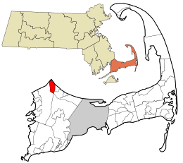
Location in Barnstable County and the state of Massachusetts.
|
|
| Country | United States |
| State | Massachusetts |
| County | Barnstable |
| Town | Bourne |
| Area | |
| • Total | 3.51 sq mi (9.09 km2) |
| • Land | 3.33 sq mi (8.62 km2) |
| • Water | 0.18 sq mi (0.46 km2) |
| Elevation | 56 ft (17 m) |
| Population
(2020)
|
|
| • Total | 3,851 |
| • Density | 1,156.46/sq mi (446.51/km2) |
| Time zone | UTC-5 (Eastern (EST)) |
| • Summer (DST) | UTC-4 (EDT) |
| ZIP Code |
02561
|
| Area code(s) | 508 |
| FIPS code | 25-58965 |
| GNIS feature ID | 2378214 |
Sagamore is a small community in Massachusetts, United States. It is a census-designated place (CDP) located in the town of Bourne. Sagamore is part of Barnstable County. In 2020, about 3,851 people lived there.
The name "Sagamore" comes from a word used by Native Americans in the northeastern United States. It meant an elected chief or leader.
Contents
Exploring Sagamore's Location
Sagamore is found in the very northeast part of the town of Bourne. It has some interesting neighbors and features. To the northeast, it touches the beautiful Cape Cod Bay. To the northwest, it borders the town of Plymouth.
Key Features of Sagamore
The western side of Sagamore is next to the Massachusetts Route 3 highway. To the southwest and south, you'll find U.S. Route 6, also known as the Mid-Cape Highway. The town of Sandwich is to the east.
The northern part of Sagamore is right along the shore of Cape Cod Bay. This area is known as Sagamore Beach.
The Cape Cod Canal and Bridge
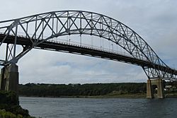
A very important waterway, the Cape Cod Canal, runs through the southern part of Sagamore. This canal goes from east to west. The famous Sagamore Bridge crosses over this canal. It carries Route 6, connecting Sagamore to other areas.
Sagamore's Size
Sagamore covers a total area of about 9.1 square kilometers (3.5 square miles). Most of this area is land, about 8.6 square kilometers (3.3 square miles). The rest, about 0.5 square kilometers (0.18 square miles), is water. This means about 5% of Sagamore's area is covered by water.
Who Lives in Sagamore?
| Historical population | |||
|---|---|---|---|
| Census | Pop. | %± | |
| 2020 | 3,851 | — | |
| U.S. Decennial Census | |||
In 2000, there were 3,544 people living in Sagamore. These people lived in 1,307 households, with 968 of them being families. The population density was about 407 people per square kilometer. Most people living in Sagamore identified as White.
See also
 In Spanish: Sagamore (Massachusetts) para niños
 | Toni Morrison |
 | Barack Obama |
 | Martin Luther King Jr. |
 | Ralph Bunche |

