Pine Hill (Barnstable County, Massachusetts) facts for kids
Quick facts for kids Pine Hill |
|
|---|---|

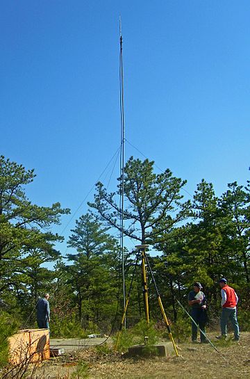
Summit of Pine Hill
|
|
| Highest point | |
| Elevation | 306 ft (93 m) |
| Prominence | 306 ft (93 m) |
| Geography | |
| Location | Bourne, MA, U.S. |
| Parent range | Buzzards Bay Moraine |
| Topo map | USGS Pocasset |
| Climbing | |
| Easiest route | Road |
Pine Hill is a special place in Bourne, Massachusetts. It's the highest point in all of Barnstable County and on Cape Cod. This means it's taller than any other hill around! Pine Hill stands at about 306 feet (93 meters) high. It's even taller than Scargo Hill in Dennis, which some people mistakenly think is the highest.
You can find Pine Hill off Frank Perkins Road. It's inside Camp Edwards, which is part of the Massachusetts Military Reservation. Because it's on a military base, you can't just walk up to it. Access is limited, partly because it's near an area where the military practices with cannons.
How Pine Hill Was Formed
Pine Hill is part of something called the Buzzards Bay Moraine. This whole area was shaped over ten thousand years ago. Huge sheets of ice, called glaciers, slowly moved across the land during the last ice age. As these glaciers melted and pulled back, they left behind piles of dirt, rocks, and sand. This is how Pine Hill was created!
The hill is about two miles (3.2 km) from Buzzards Bay. It's also about a mile from Massachusetts Route 28. The ground around Pine Hill is very sandy. You'll also see many large rocks and lots of pitch pine trees. These trees are so common that they gave the hill its name! The area also has smaller, bumpy hills and a few tiny ponds formed by the melting glaciers.
People have known about Pine Hill for a long time. It was first noted as an important landmark in 1874. Back then, it was part of the town of Sandwich. The town of Bourne wasn't even created until ten years later.
Military Use of the Area
The military started using the land around Pine Hill in 1911. Later, in 1935, the state built the Massachusetts Military Reservation complex. This happened because the Massachusetts National Guard needed more space than their old base, Fort Devens, could offer.
Even though the military uses the surrounding land, the Pine Hill area itself has mostly stayed natural. There's a road near it, but not much else has been built there. In 1999, the governor at the time, Paul Cellucci, wanted to turn the area into a state park. However, the National Guard needed the land for their training, so the plan didn't happen.
Visiting Pine Hill Safely
If you want to visit Pine Hill, you can! But you need to plan ahead. You must get permission from the base's Public Affairs Office (PAO). When you visit the base, you'll also need to show your identification. These rules were in place even before the events of September 11, 2001. However, they have been followed even more carefully since then.
A PAO escort will guide visitors over several miles of roads. They will take you to a special station near the hill. From there, it's a short walk down Frank Perkins Road. Then, you'll take a narrow path up a gentle slope to the very top of Pine Hill.
The summit is a small, clear area. You'll see a small concrete marker there with a USGS benchmark. This marker shows the exact 306-foot (93-meter) elevation. It's very important to stay on the road and path. This is because there might be unexploded training items in the woods. Sometimes, you might see special equipment at the top for surveying or studying the weather. Even though it's the highest point, tall trees around the summit block most of the views.
 | Calvin Brent |
 | Walter T. Bailey |
 | Martha Cassell Thompson |
 | Alberta Jeannette Cassell |

