Buzzards Bay, Massachusetts facts for kids
Quick facts for kids
Buzzards Bay, Massachusetts
|
|
|---|---|

|
|

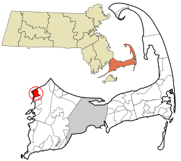
Location in Barnstable County and the state of Massachusetts.
|
|
| Country | United States |
| State | Massachusetts |
| County | Barnstable |
| Town | Bourne |
| Settled | 1621 |
| Area | |
| • Total | 2.96 sq mi (7.66 km2) |
| • Land | 1.92 sq mi (4.96 km2) |
| • Water | 1.04 sq mi (2.70 km2) |
| Elevation | 10 ft (3 m) |
| Population
(2020)
|
|
| • Total | 4,279 |
| • Density | 2,233.30/sq mi (862.43/km2) |
| Time zone | UTC-5 (Eastern (EST)) |
| • Summer (DST) | UTC-4 (EDT) |
| ZIP codes |
02532, 02542
|
| Area code(s) | 508 |
| FIPS code | 25-10015 |
| GNIS feature ID | 0616369 |
Buzzards Bay is a community located in the town of Bourne, in Barnstable County, Massachusetts, United States. It is a special kind of area called a "census-designated place" (CDP). In 2020, about 4,279 people lived here. This makes it the most populated CDP in Bourne.
Contents
Where is Buzzards Bay?
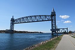
Buzzards Bay is located at 41°45′5″N 70°36′49″W / 41.75139°N 70.61361°W. It is one of three communities in Barnstable County that are on the mainland side of the Cape Cod Canal. The ground here is mostly sandy.
The area covers about 7.6 square kilometers (2.9 square miles). Most of this is land (about 5.0 square kilometers or 1.9 square miles). The rest is water (about 2.6 square kilometers or 1.0 square mile). This water mainly comes from Buttermilk Bay, which is part of the larger Buzzards Bay. Buttermilk Bay forms the western edge of the community.
Who Lives in Buzzards Bay?
| Historical population | |||
|---|---|---|---|
| Census | Pop. | %± | |
| 2020 | 4,279 | — | |
| U.S. Decennial Census | |||
In 2000, there were 3,549 people living in Buzzards Bay. There were 1,216 households, and 795 families. The population density was about 692 people per square kilometer (1,793 people per square mile).
The average household had about 2.29 people. The average family had about 2.78 people.
The population was spread out by age:
- 15.9% were under 18 years old.
- 23.0% were between 18 and 24.
- 23.5% were between 25 and 44.
- 20.7% were between 45 and 64.
- 17.0% were 65 years or older.
The average age of people living here was 35 years. For every 100 females, there were about 121.7 males.
The median income for a household was $99,750. For a family, the median income was $142,165. The average income per person was $88,304. Only a small number of families (0.4%) and people (1.7%) lived below the poverty line.
History of Buzzards Bay
Buzzards Bay was originally the land of the Wampanoag people. The name "Buzzards Bay" likely came from the large birds seen there, like turkey vultures or ospreys. European settlers arrived in Buzzards Bay in 1621.
One famous person who lived here was Grover Cleveland, a former President of the United States. He had a "Summer White House" at his home called Agawam Point in Buzzards Bay. Sadly, his home was destroyed by a fire on December 10, 1973.
Culture and Education
Buzzards Bay has some interesting places and schools.
Marine Life Center
Buzzards Bay is home to the National Marine Life Center. This is a special place that acts like a hospital for marine animals. They help sea turtles and seals that are stranded. Their goal is to get these animals healthy enough to go back into the wild. The center also teaches people about marine wildlife health and how to protect the ocean.
Massachusetts Maritime Academy
Buzzards Bay is also where the Massachusetts Maritime Academy is located. This is a college that trains students for careers in the maritime industry, like working on ships or in marine engineering.
Local Schools
The public schools in the area are run by Bourne Public Schools. This includes Bourne High School.
There were also Catholic schools nearby. St. Margaret Primary School in Buzzards Bay closed in 2020. Students from that school could then go to other Catholic schools like St. Francis Xavier School, St. Joseph School, or St. Pius X School.
See also
In Spanish: Buzzards Bay (Massachusetts) para niños
 | Lonnie Johnson |
 | Granville Woods |
 | Lewis Howard Latimer |
 | James West |

