East Falmouth, Massachusetts facts for kids
Quick facts for kids
East Falmouth, Massachusetts
|
|
|---|---|

East Branch
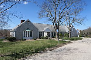
Falmouth Public Library |
|

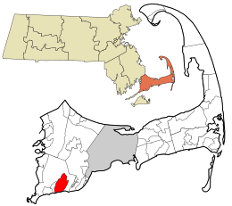
Location in Barnstable County and the state of Massachusetts.
|
|
| Country | United States |
| State | Massachusetts |
| County | Barnstable |
| Town | Falmouth |
| Area | |
| • Total | 6.29 sq mi (16.29 km2) |
| • Land | 5.44 sq mi (14.08 km2) |
| • Water | 0.85 sq mi (2.21 km2) |
| Elevation | 36 ft (11 m) |
| Population
(2020)
|
|
| • Total | 6,278 |
| • Density | 1,154.89/sq mi (445.91/km2) |
| Time zone | UTC-5 (Eastern (EST)) |
| • Summer (DST) | UTC-4 (EDT) |
| ZIP code |
02536
|
| Area code(s) | 508 |
| FIPS code | 25-18980 |
| GNIS feature ID | 0616388 |
East Falmouth is a special kind of community called a census-designated place (CDP). It's located in the town of Falmouth in Barnstable County, Massachusetts, United States. You can find it at the bottom of Massachusetts' "fishhook" shaped peninsula. In 2010, about 6,038 people lived here, making it the biggest CDP in Falmouth.
Contents
Where is East Falmouth?
East Falmouth is in the southeastern part of Falmouth. It's next to the village of Teaticket on its west side. To the east, you'll find the Childs River. The southern edge of East Falmouth touches the water of Vineyard Sound.
The area covers about 16.3 square kilometers (6.3 square miles). Most of this is land, about 14.1 square kilometers (5.4 square miles). The rest, about 2.2 square kilometers (0.85 square miles), is water.
Neighborhoods in East Falmouth
South of Massachusetts Route 28, East Falmouth is divided into four main areas. These areas are like natural neighborhoods. They are separated by small water channels called tidal creeks or "ponds." From east to west, these neighborhoods are:
- Seacoast Shores
- Menauhant
- Davisville
- Acapesket
Each neighborhood has its own unique features and sometimes a community group.
Seacoast Shores
Seacoast Shores used to be called Jenkin's Neck. It's one of the most crowded neighborhoods in Falmouth, with 905 homes. The Seacoast Shores Association is a group that helps take care of the area. They look after 22 public pathways and a private beach. These are for people who live in the neighborhood and are members of the association.
Great Harbors
Great Harbors is a private community within the Acapesket area. It has about 400 houses spread across 11 streets. The Great Harbors Resident Association manages this community. It was started in December 1966. Great Harbors is right on the water. It has a long street along the water, a pool, tennis courts, and two boat docks. A group of volunteers, chosen by the community members, helps run Great Harbors.
Other Nearby Areas
There are two small villages close to East Falmouth that are not part of its official census area. Hatchville is to the north, near Coonamessett Pond. Waquoit is to the east, along Route 28. Even though they are separate, these villages use the East Falmouth postal service.
People in East Falmouth
| Historical population | |||
|---|---|---|---|
| Census | Pop. | %± | |
| 2020 | 6,278 | — | |
| U.S. Decennial Census | |||
In 2000, there were 6,615 people living in East Falmouth. These people lived in 2,828 homes, with 1,923 of them being families. The population density was about 469 people per square kilometer (1,215 people per square mile). There were also 4,323 housing units.
Most people in East Falmouth were White. There were also smaller groups of African American, Native American, and Asian residents. Some people identified with two or more races. A small percentage of the population was Hispanic or Latino.
About 24% of the homes had children under 18 years old. Many homes were married couples living together. Some homes had a female head of household without a husband. About 27% of homes were individuals living alone.
The average age of people in East Falmouth was 44 years old. About 21.5% of the population was under 18. About 22.9% were 65 years or older.
See also
 In Spanish: East Falmouth para niños
 | Misty Copeland |
 | Raven Wilkinson |
 | Debra Austin |
 | Aesha Ash |

