Shining Sea Bikeway facts for kids
Quick facts for kids Shining Sea Bikeway |
|
|---|---|

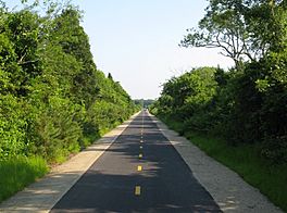
The trail in West Falmouth
|
|
| Length | 10.7 mi (17.2 km) |
| Location | Barnstable County |
| Trailheads | 1 Cowdry Road, Woods Hole County Road, North Falmouth |
| Use | Hiking, bicycling, horseback riding, roller blading, and cross country skiing |
| Difficulty | Easy |
| Season | year-round |
| Hazards | deer ticks poison ivy road crossings |
| Surface | Paved surface |
| Right of way | former railroad line |
The Shining Sea Bikeway is a fun path for walking, biking, and even rollerblading on Cape Cod in Falmouth, Massachusetts, United States. This beautiful trail stretches for about 10.7 miles (17.2 km). It goes from the Steamship Authority ferry terminal in Woods Hole all the way to North Falmouth. It's a great way to explore the area and enjoy nature!
Contents
A Path with a Past
The Shining Sea Bikeway wasn't always a path for bikes and walkers. It was built on an old railroad line. This line was part of the Old Colony Railroad's Woods Hole branch, which opened in 1872.
From Trains to Trails
In 1893, another company, the New York, New Haven and Hartford Railroad, took over the line. Passenger trains stopped running on this line in 1964. Later, the railroad company went out of business.
The idea to turn the old railroad into a trail started in 1977. The town of Falmouth bought a part of the line. This section ran from downtown Falmouth to Woods Hole.
Growing the Trail
In 2009, the trail got even longer! It was extended about 8 more miles (13 km). This new part went from downtown Falmouth to North Falmouth. Freight trains had stopped using this section in 1989.
The part of the trail from Woods Hole to Falmouth is owned by the town. The longer part, from Falmouth to North Falmouth, is owned by the state of Massachusetts.
Where the Name Comes From
The trail's name, "Shining Sea Bikeway," comes from the famous patriotic song "America the Beautiful." The person who wrote the words for the song, Katherine Lee Bates, was born in Falmouth. You can find a special plaque (a small sign) honoring her poem near mile marker 2 on the trail.
Future Connections
There are plans for another trail called the Bourne Rail Trail. It will be about 6.5 miles (10.5 km) long. This new trail will run next to an active train line from North Falmouth to Bourne. It will connect with the Cape Cod Canal path, making even more places to explore!
Exploring the Bikeway
The Shining Sea Bikeway offers a wonderful journey through different landscapes. It's a mostly flat and easy path for everyone to enjoy.
Starting Your Adventure
The northern end of the bikeway is in North Falmouth. It starts near where the old North Falmouth Railroad Station used to be. For a short distance, the path runs next to an active train track. This track is used to move trash away from Cape Cod.
As you head south, the path follows along Route 28A. You'll go through the villages of North Falmouth and West Falmouth.
Nature's Beauty
Between North and West Falmouth, the trail passes through a cranberry bog. This is a wet area where cranberries grow. You'll also cross horse trails at Bourne Farm. In West Falmouth, the path goes near Chapoquoit Beach. Then, it winds through the Sippewissett Salt Marsh. A salt marsh is a coastal wetland that is flooded by ocean tides.
Into Falmouth
After the salt marsh, the path turns southeast and goes up a small hill into the village of Sippewissett. Then it turns southwest and enters downtown Falmouth. Here, you can connect to the Moraine Trail. This trail leads to places like Goodwill Park and Grew's Pond.
In Falmouth, the bikeway goes through a Steamship Authority parking lot. It also passes the old Falmouth Railroad Station. This building is now used as a bus station.
The Final Stretch to Woods Hole
The path then reaches its downtown parking lot at Woods Hole Road. This used to be the end of the trail before it was extended in 2009. You'll cross Woods Hole Road and continue southwest past Salt Pond to Surf Drive Beach.
At Surf Drive, the path follows the beach for about half a mile (0.8 km). It then heads inland. Turning east, it goes through another Steamship Authority parking lot. The trail finally ends at the Steamship Authority ferry terminal. This is also where the old Woods Hole Railroad Station used to be.
 | Selma Burke |
 | Pauline Powell Burns |
 | Frederick J. Brown |
 | Robert Blackburn |

