Falmouth (CDP), Massachusetts facts for kids
Quick facts for kids
Falmouth, Massachusetts
|
|
|---|---|

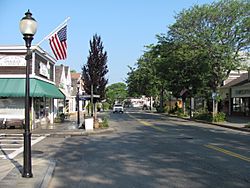
Main Street
|
|

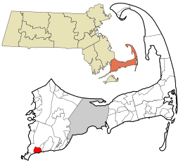
Location in Barnstable County and the state of Massachusetts.
|
|
| Country | United States |
| State | Massachusetts |
| County | Barnstable |
| Town | Falmouth |
| Area | |
| • Total | 2.25 sq mi (5.84 km2) |
| • Land | 2.09 sq mi (5.41 km2) |
| • Water | 0.17 sq mi (0.43 km2) |
| Elevation | 7 ft (2 m) |
| Population
(2020)
|
|
| • Total | 3,818 |
| • Density | 1,828.54/sq mi (706.03/km2) |
| Time zone | UTC-5 (Eastern (EST)) |
| • Summer (DST) | UTC-4 (EDT) |
| ZIP codes |
02540, 02541, 02543
|
| Area code(s) | 508 |
| FIPS code | 25-23070 |
| GNIS feature ID | 0616278 |
Falmouth is a special area in the town of Falmouth, located in Barnstable County, Massachusetts, USA. It's called a "census-designated place" (CDP). This means it's a specific area that the government counts for population, but it's not a separate city or town.
In 2020, about 3,818 people lived in the Falmouth CDP. The larger town of Falmouth has many more people. This area was named after Falmouth, a town in Cornwall, England.
Where is Falmouth?
Falmouth CDP is in the southern part of the larger town of Falmouth. You can find it at these coordinates: 41°32′54″N 70°36′17″W / 41.54833°N 70.60472°W.
It has neighbors all around it. To the east, you'll find the Teaticket area. To the south is Vineyard Sound, which is a body of water. Woods Hole is to the southwest, and West Falmouth is to the northwest.
The main road that goes through Falmouth CDP is Massachusetts Route 28. It's known as Palmer Avenue and Main Street in this area.
Land and Water
The Falmouth CDP covers a total area of about 5.8 square kilometers (or 2.25 square miles). Most of this area is land, about 5.4 square kilometers (2.09 square miles). The rest, about 0.4 square kilometers (0.17 square miles), is water. This means about 7.5% of the area is water.
Who Lives in Falmouth?
| Historical population | |||
|---|---|---|---|
| Census | Pop. | %± | |
| 2020 | 3,818 | — | |
| U.S. Decennial Census | |||
In 2000, there were 4,115 people living in the Falmouth CDP. There were 2,125 homes, and 988 of these were families. The area had about 767 people per square kilometer. There were also many housing units, about 3,088 in total.
Population Details
The people living in Falmouth CDP are of different ages.
- About 12.5% of the people were under 18 years old.
- About 3.2% were between 18 and 24 years old.
- About 21.7% were between 25 and 44 years old.
- About 26.5% were between 45 and 64 years old.
- The largest group, about 36.1%, were 65 years old or older.
The average age of people in Falmouth CDP was 54 years. For every 100 females, there were about 76.7 males.
See also
 In Spanish: Falmouth (condado de Barnstable) para niños
 | Lonnie Johnson |
 | Granville Woods |
 | Lewis Howard Latimer |
 | James West |

