Binghamton metropolitan area facts for kids
Quick facts for kids
Greater Binghamton
|
||
|---|---|---|
| Binghamton, NY Metropolitan Statistical Area | ||

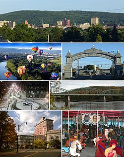
Clockwise from top: Downtown Binghamton skyline, the Endicott Johnson Square Deal Arch, the South Washington Street Bridge, the Ross Park Zoo carousel, Court Street Historic District, downtown in winter, and the Spiedie Fest and Balloon Rally
|
||
|
||
| Country | ||
| State | ||
| Largest city | Binghamton | |
| Population
(2020)
|
||
| • Total | ||
| • Rank | 193rd in the U.S. | |
| Time zone | UTC−5 (EST) | |
| • Summer (DST) | UTC−4 (EDT) | |
Greater Binghamton is a special area in southern Upstate New York. It is also known as the Binghamton Metropolitan Statistical Area or the Triple Cities. This region is centered around the city of Binghamton.
The area includes Broome County and Tioga County. In 2020, about 247,138 people lived here. Greater Binghamton is located near the border with Pennsylvania. It is about 66 miles (110 km) south of Syracuse.
The name "Greater Binghamton" became popular in the early 2000s. This was done to help people recognize the area better. It helps to promote the region using its most famous city.
Contents
The Triple Cities Area
The region has long been called the Triple Cities. This name refers to three main places: Binghamton, Johnson City, and Endicott. Johnson City and Endicott are officially villages, but they are very important to the area.
Binghamton is the largest of the three. It has more people than Johnson City and Endicott combined. These three areas are very close together. They look like one big, spread-out city. Even though they have their own governments, their economies are closely linked.
The idea of joining these three places into one big city has been discussed. However, it is not likely to happen soon. The term "Triple Cities" also includes nearby areas. These include Endwell, West Corners, and Vestal. Vestal is home to the Vestal Parkway. This is a major shopping area with stores and restaurants. Binghamton University is also located in Vestal.
Getting Around Greater Binghamton
The main towns of Binghamton, Johnson City, and Endicott are connected by major roads. The Southern Tier Expressway (NY 17) runs through them. This road will become Interstate 86 in the future.
Other important highways include Interstate 81 and Interstate 88. I-81 connects the area to Syracuse and Pennsylvania. NY 17 links to New York City and Western New York. I-88 provides connections to Albany and New England. U.S. Route 11 and New York State Route 12 are also key roads.
Main Street (NY 17C) is a long road that goes through the heart of the urban area. It starts in downtown Binghamton and continues through Johnson City, Endwell, and Endicott.
Broome County Transit runs 14 bus routes in the area. You can also travel to other cities by bus. Greyhound Bus Lines and New York Trailways offer services from Binghamton. They connect to places like Ithaca, Syracuse, and New York City.
The Greater Binghamton Airport is in Johnson City. Currently, Delta and Avelo airlines fly from this airport.
Communities in the Area
The Greater Binghamton area includes many different communities. These are organized into cities, towns, villages, and other smaller places.
Cities
- Binghamton (This is the main city)
Towns
Villages
- Candor
- Deposit (partially)
- Endicott
- Johnson City
- Lisle
- Newark Valley
- Nichols
- Owego
- Port Dickinson
- Spencer
- Waverly
- Whitney Point
- Windsor
Census-Designated Places
Hamlets
- Campville
- Chenango Forks
- Killawog
- Hillcrest
- Nineveh
- Westover
Population Facts
In 2010, about 251,725 people lived in the Greater Binghamton area. Most residents, about 89.8%, were White. About 4.0% were African American, and 3.0% were Asian. About 3.0% of the population was Hispanic or Latino.
In 2000, the average income for a family in the area was about $45,966 per year. The average income for each person was about $18,921.
| Historical Population | ||
|---|---|---|
| Year | Pop. | ±% |
| 1990 | 264,497 | — |
| 2000 | 253,320 | −4.2% |
| 2010 | 251,725 | −0.6% |
| 2020 | 247,135 | −1.8% |
| Source: | ||
| County | 2022 Estimate | 2020 Census | Change | Area | Density |
|---|---|---|---|---|---|
| Broome County | 197,117 | 198,683 | −0.79% | 705.77 sq mi (1,827.9 km2) | 279/sq mi (108/km2) |
| Tioga County | 47,772 | 48,455 | −1.41% | 518.60 sq mi (1,343.2 km2) | 92/sq mi (36/km2) |
| Total MSA Population | 244,889 | 247,138 | −0.91% | 1,224.37 sq mi (3,171.1 km2) | 200/sq mi (77/km2) |
Colleges and Universities
The Greater Binghamton area is home to several colleges and universities. These offer different types of education for students.
Broome County Schools
- Binghamton University in Vestal
- SUNY Broome in Dickinson
- Davis College in Johnson City (This school is no longer open)
- Elmira Business Institute in Vestal (This school is no longer open)
- In Binghamton:
- Empire State College learning center
- Ridley-Lowell Business and Technical Institute's Binghamton campus (This school is no longer open)
- State University of New York Upstate Medical University clinical campus
Tioga County Schools
See also
 In Spanish: Área metropolitana de Binghamton para niños
 | Sharif Bey |
 | Hale Woodruff |
 | Richmond Barthé |
 | Purvis Young |

