Dickinson, Broome County, New York facts for kids
Quick facts for kids
Dickinson, New York
|
|
|---|---|

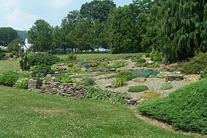
Cutler Botanic Gardens in Dickinson
|
|
| Motto(s):
A community rich in history and family
|
|

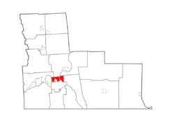
Map highlighting Dickinson's location within Broome County.
|
|
| Country | United States |
| State | New York |
| County | Broome |
| Government | |
| • Type | Town Council |
| Area | |
| • Total | 4.87 sq mi (12.60 km2) |
| • Land | 4.77 sq mi (12.34 km2) |
| • Water | 0.10 sq mi (0.26 km2) |
| Elevation | 843 ft (257 m) |
| Population
(2020)
|
|
| • Total | 5,083 |
| • Estimate
(2021)
|
5,036 |
| • Density | 1,084.14/sq mi (418.62/km2) |
| Time zone | UTC-5 (Eastern (EST)) |
| • Summer (DST) | UTC-4 (EDT) |
| ZIP code |
13905
|
| Area code(s) | 607 |
| FIPS code | 36-20588 |
| GNIS feature ID | 0978903 |
Dickinson is a small town in Broome County, New York, United States. It's located right next to the city of Binghamton, acting like a nearby neighborhood or suburb. In 2020, about 5,083 people lived here. The town was named after a person called Daniel S. Dickinson.
Contents
History of Dickinson
The town of Dickinson was officially created in 1890. It was formed from a part of the larger Town of Binghamton.
Long ago, between 1834 and 1876, a waterway called the Chenango Canal ran through the town. It followed the Chenango River. A village called Port Dickinson grew up around a busy spot on this canal. The canal was important because it connected Binghamton to other places like Troy and the famous Erie Canal.
Exploring Dickinson's Geography
Dickinson covers an area of about 12.6 square kilometers (or 4.87 square miles). Most of this area is land, with a small part being water.
The town is split in half by the Chenango River, which flows through it.
Major roads also pass through Dickinson. Interstate 81 meets Interstate 88 near the northern edge of the town. U.S. Route 11 goes through the southern part, and New York State Route 7 is a main road on the eastern side.
Neighboring Areas
Dickinson shares its borders with several other towns and cities:
- To the north, you'll find the towns of Chenango and Fenton.
- To the east is the town of Kirkwood.
- To the south is the city of Binghamton.
- To the west, Dickinson is next to the town of Union, which includes the village of Johnson City.
Who Lives in Dickinson?
| Historical population | |||
|---|---|---|---|
| Census | Pop. | %± | |
| 1900 | 728 | — | |
| 1910 | 832 | 14.3% | |
| 1920 | 1,975 | 137.4% | |
| 1930 | 4,255 | 115.4% | |
| 1940 | 5,060 | 18.9% | |
| 1950 | 5,450 | 7.7% | |
| 1960 | 6,591 | 20.9% | |
| 1970 | 5,687 | −13.7% | |
| 1980 | 5,594 | −1.6% | |
| 1990 | 5,486 | −1.9% | |
| 2000 | 5,339 | −2.7% | |
| 2010 | 5,278 | −1.1% | |
| 2020 | 5,083 | −3.7% | |
| 2021 (est.) | 5,036 | −4.6% | |
| U.S. Decennial Census | |||
According to the census from 2000, there were 5,335 people living in Dickinson. The population density was about 1,114.8 people per square mile.
The average age of people in the town was 41 years old. About 19% of the population was under 18 years old.
Places to See in Dickinson
- SUNY Broome Community College – This is a public two-year college located on the west side of the Chenango River.
- Cutler Botanic Garden – A beautiful botanical garden where you can see many different kinds of plants.
- Otsiningo Park – A park found on the west bank of the Chenango River, great for outdoor activities.
- Port Dickinson – This is a village located on the east bank of the Chenango River.
Images for kids
See also
 In Spanish: Dickinson (condado de Broome, Nueva York) para niños
 | Selma Burke |
 | Pauline Powell Burns |
 | Frederick J. Brown |
 | Robert Blackburn |


