Union, New York facts for kids
Quick facts for kids
Union, New York
|
|
|---|---|

Village of Endicott
|
|

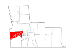
Map highlighting Union's location within Broome County.
|
|
| Country | United States |
| State | New York |
| County | Broome |
| Established | 1791 |
| Government | |
| • Type | Town Council |
| Area | |
| • Total | 36.02 sq mi (93.30 km2) |
| • Land | 35.47 sq mi (91.86 km2) |
| • Water | 0.56 sq mi (1.44 km2) 1.49% |
| Elevation | 981 ft (299 m) |
| Population
(2010)
|
|
| • Total | 56,346 |
| • Estimate
(2016)
|
54,790 |
| • Density | 1,544.82/sq mi (596.45/km2) |
| Time zone | UTC-5 (EST) |
| • Summer (DST) | UTC-4 (EDT) |
| FIPS code | 36-007-76056 |
| GNIS feature ID | 0979572 |
Union is a town located in Broome County, New York, United States. In 2010, about 56,346 people lived there. The town got its name because it was a meeting spot, or "rendezvous," for soldiers during the Sullivan Expedition long ago.
Union is in the south-central part of Broome County, just west of Binghamton. The towns and villages in Union are like the western neighborhoods of Binghamton. Together, the villages of Johnson City and Endicott, along with Binghamton, are often called the "Triple Cities."
Contents
A Look Back: Union's History
People from America and Europe first started settling in this area around 1782.
Union's Role in the American Revolution
During the American Revolution, soldiers marched through this region. Their goal was to attack Native American villages that were helping the British. Records show that many Native Americans were killed in these attacks in 1779. This happened in places like present-day Binghamton, Vestal, and Choconut Township, Pennsylvania.
Two generals, General Poor and General Sullivan, led their troops on separate paths. Their soldiers met up at the spot where Union is today. This meeting point is why the town was named "Union."
How Union Became a Town
The town of Union was officially created in 1791. At that time, it was part of Tioga County, before Broome County was formed. Union was one of the first towns in the area. Over time, parts of Union were used to create other towns.
- In 1800, the town of Owego was formed.
- In 1801, Lisle was created.
- In 1808, Greene was formed (now in Chenango County).
- In 1823, Vestal became its own town.
- Finally, in 1848, Maine was established.
Union's Geography
Union covers a total area of about 36.02 square miles (93.2 square kilometers). Most of this is land, about 35.47 square miles (91.8 square kilometers). A small part, about 0.56 square miles (1.4 square kilometers), is water.
The town of Union is located on the north side of the Susquehanna River.
Roads and Highways
Several important roads pass through Union:
- New York State Route 17 crosses the Susquehanna River in Union.
- New York State Route 26 and New York State Route 38B meet near Union Center.
- NY-26 connects Union to the town of Vestal, which is on the south side of the Susquehanna River.
- New York State Route 17C is a road that runs east and west in the southern part of Union.
Population Information
| Historical population | |||
|---|---|---|---|
| Census | Pop. | %± | |
| 1820 | 2,037 | — | |
| 1830 | 2,122 | 4.2% | |
| 1840 | 3,165 | 49.2% | |
| 1850 | 2,143 | −32.3% | |
| 1860 | 2,092 | −2.4% | |
| 1870 | 2,538 | 21.3% | |
| 1880 | 2,596 | 2.3% | |
| 1890 | 2,711 | 4.4% | |
| 1900 | 5,707 | 110.5% | |
| 1910 | 9,486 | 66.2% | |
| 1920 | 25,651 | 170.4% | |
| 1930 | 42,579 | 66.0% | |
| 1940 | 50,195 | 17.9% | |
| 1950 | 55,676 | 10.9% | |
| 1960 | 64,423 | 15.7% | |
| 1970 | 64,490 | 0.1% | |
| 1980 | 61,179 | −5.1% | |
| 1990 | 59,786 | −2.3% | |
| 2000 | 56,266 | −5.9% | |
| 2010 | 56,346 | 0.1% | |
| 2018 (est.) | 53,251 | −5.5% | |
| U.S. Decennial Census | |||
According to the census from 2000, there were 56,298 people living in Union. These people lived in 24,538 households, and 14,551 of these were families. The population density was about 1,600 people per square mile. There were also 26,507 housing units.
About 92.72% of the people were White, 2.45% were African American, and 2.68% were Asian. About 1.53% of the population identified as Hispanic or Latino.
In 2000, about 26.1% of households had children under 18 living with them. About 45.0% were married couples. The average household had 2.24 people, and the average family had 2.90 people.
The population's age was spread out. About 21.9% were under 18 years old. The median age was 40 years. This means half the people were younger than 40 and half were older.
The median income for a household in Union was $34,101. For families, the median income was $46,170. About 11.3% of the population lived below the poverty line. This included 16.4% of those under 18.
Communities and Locations in Union
The Town of Union includes several smaller communities and places:
- Choconut Center – A small community in the northeastern part of the town.
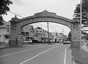
- Endicott – A village on the north side of the Susquehanna River in western Union.
- Endwell – A community located between Endicott and Johnson City. It used to be called "Hooper."
- Johnson City – A village next to Binghamton, on the north side of the Susquehanna River at the eastern edge of Union.
- Tri-Cities Airport (CZG) – An airport for smaller planes in the southwestern part of Union.
- Union Center – A community near the northern border of the town.
- West Corners – A community north of Endicott.
- Westover – A community along the western edge of Johnson City.
- West Endicott – A community next to Endicott and West Corners.
See also
 In Spanish: Union (Nueva York) para niños
 | William M. Jackson |
 | Juan E. Gilbert |
 | Neil deGrasse Tyson |


