Maine, New York facts for kids
Quick facts for kids
Maine, New York
|
|
|---|---|

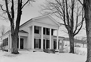
Cyrus Gates House in Maine
|
|

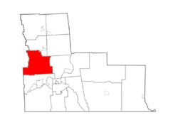
Map highlighting Maine's location within Broome County.
|
|
| Country | United States |
| State | New York |
| County | Broome |
| Government | |
| • Type | Town Council |
| Area | |
| • Total | 45.76 sq mi (118.52 km2) |
| • Land | 45.64 sq mi (118.22 km2) |
| • Water | 0.12 sq mi (0.30 km2) |
| Elevation | 1,385 ft (422 m) |
| Population
(2010)
|
|
| • Total | 5,377 |
| • Estimate
(2016)
|
5,238 |
| • Density | 114.76/sq mi (44.31/km2) |
| Time zone | UTC-5 (Eastern (EST)) |
| • Summer (DST) | UTC-4 (EDT) |
| ZIP code |
13802
|
| Area code(s) | 607 |
| FIPS code | 36-007-44611 |
| GNIS feature ID | 0979184 |
Maine is a small town in Broome County, New York, United States. It's located in the state of New York. In 2010, about 5,377 people lived there.
The town is on the western edge of Broome County. It is also northwest of a larger city called Binghamton. Maine is also home to the Greater Binghamton Airport, which serves Binghamton and the areas around it.
Contents
History of Maine
Early Settlements
People first started settling in the Maine area in 1794. The town of Maine was officially created on March 27, 1848. It was formed from the northern part of another town called Union.
Historic Buildings
Two important places in Maine are listed on the National Register of Historic Places. This means they are special buildings that are worth preserving.
- The Maine Central School (also known as J. Ralph Ingals School) was added to the list in 1998.
- The Cyrus Gates Farmstead was added in 1999.
Geography of Maine
Land and Water
The town of Maine covers a total area of about 45.76 square miles (118.5 square kilometers). Most of this area is land, about 45.64 square miles (118.2 square kilometers). Only a small part, about 0.12 square miles (0.3 square kilometers), is water.
Nearby Areas and Roads
The western border of Maine is also the border of Tioga County. This means Maine is right next to Tioga County.
Two main highways pass through the town:
- New York State Route 26 runs from north to south.
- New York State Route 38B crosses the southwest corner of Maine.
Famous Connections
Maine is known as the birthplace of Lamont Bowers. He was an important advisor to John D. Rockefeller, a very famous businessman.
Population of Maine
How Many People Live Here?
The population of Maine has changed over the years. Here's how many people have lived in the town during different census years:
| Historical population | |||
|---|---|---|---|
| Census | Pop. | %± | |
| 1850 | 1,843 | — | |
| 1860 | 1,609 | −12.7% | |
| 1870 | 2,035 | 26.5% | |
| 1880 | 2,129 | 4.6% | |
| 1890 | 1,692 | −20.5% | |
| 1900 | 1,534 | −9.3% | |
| 1910 | 1,363 | −11.1% | |
| 1920 | 1,360 | −0.2% | |
| 1930 | 1,628 | 19.7% | |
| 1940 | 2,076 | 27.5% | |
| 1950 | 2,315 | 11.5% | |
| 1960 | 3,931 | 69.8% | |
| 1970 | 5,842 | 48.6% | |
| 1980 | 5,262 | −9.9% | |
| 1990 | 5,576 | 6.0% | |
| 2000 | 5,459 | −2.1% | |
| 2010 | 5,377 | −1.5% | |
| 2016 (est.) | 5,238 | −2.6% | |
| U.S. Decennial Census | |||
In 2000, there were 5,459 people living in Maine. There were 2,036 households, which are groups of people living together. Most people in Maine were White (97.89%). A small number of people were from other racial backgrounds.
Age Groups
The population in 2000 was spread out by age:
- 26.3% were under 18 years old.
- 29.0% were between 25 and 44 years old.
- 13.1% were 65 years or older.
The average age in Maine was 39 years old.
Communities and Places in Maine
Maine has several smaller communities and important locations within its borders:
- Bowers Corners – This used to be a specific location in the town.
- Greater Binghamton Airport/Edwin A. Link Field (BGM) – This is the main airport for the city of Binghamton.
- Maine – This is the main village, or hamlet, of the town. It is near the western town line on NY-26.
- East Maine – Another hamlet located southwest of the airport. You can find it where County Roads 49 and 65 meet.
- Nanticoke Creek – This is a stream that flows south through the town. It eventually joins the Susquehanna River.
- New Ireland – A hamlet located near the eastern town line on County Road 89.
- North Maine – This was once a community in the town.
- Tiona – A specific location found in the northwestern part of the town.
- Ketchumville – Another area in the northwestern part of the town. It is very close to the border with Tioga County.
Images for kids
See also
 In Spanish: Maine (Nueva York) para niños
 | George Robert Carruthers |
 | Patricia Bath |
 | Jan Ernst Matzeliger |
 | Alexander Miles |


