Chenango, New York facts for kids
Quick facts for kids
Chenango, New York
|
|
|---|---|

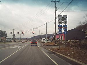
State Route 12, Chenango Bridge, NY
|
|

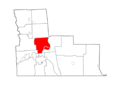
Map highlighting Chenango's location within Broome County.
|
|
| Country | United States |
| State | New York |
| County | Broome |
| Government | |
| • Type | Town Council |
| Area | |
| • Total | 34.27 sq mi (88.75 km2) |
| • Land | 33.83 sq mi (87.63 km2) |
| • Water | 0.43 sq mi (1.12 km2) |
| Elevation | 961 ft (293 m) |
| Population
(2020)
|
|
| • Total | 10,983 |
| • Estimate
(2021)
|
10,876 |
| • Density | 321.45/sq mi (124.11/km2) |
| Time zone | UTC-5 (Eastern (EST)) |
| • Summer (DST) | UTC-4 (EDT) |
| FIPS code | 36-007-15110 |
| GNIS feature ID | 0978819 |
Chenango is a town located in Broome County, New York, United States. In 2020, about 10,983 people lived there.
The town is found northeast of Binghamton.
Contents
History of Chenango
The area where Chenango is located was first settled around 1787. The Town of Chenango was officially created in 1791. This happened even before Broome County was formed. Chenango is one of the very first towns in the county. Other towns were later created from parts of Chenango.
Geography of Chenango
Chenango covers a total area of about 88.8 square kilometers (34.3 square miles). Most of this area is land, with a small part being water.
The Chenango River forms the eastern border of the town. Important roads like Interstate 81, U.S. Route 11, and New York State Route 12 all pass through Chenango.
Population Changes in Chenango
| Historical population | |||
|---|---|---|---|
| Census | Pop. | %± | |
| 1820 | 2,626 | — | |
| 1830 | 3,716 | 41.5% | |
| 1840 | 5,465 | 47.1% | |
| 1850 | 8,734 | 59.8% | |
| 1860 | 1,841 | −78.9% | |
| 1870 | 1,680 | −8.7% | |
| 1880 | 1,590 | −5.4% | |
| 1890 | 1,448 | −8.9% | |
| 1900 | 1,372 | −5.2% | |
| 1910 | 1,237 | −9.8% | |
| 1920 | 1,183 | −4.4% | |
| 1930 | 2,074 | 75.3% | |
| 1940 | 3,265 | 57.4% | |
| 1950 | 5,747 | 76.0% | |
| 1960 | 9,858 | 71.5% | |
| 1970 | 12,267 | 24.4% | |
| 1980 | 12,233 | −0.3% | |
| 1990 | 12,310 | 0.6% | |
| 2000 | 11,454 | −7.0% | |
| 2010 | 11,252 | −1.8% | |
| 2020 | 10,983 | −2.4% | |
| 2021 (est.) | 10,876 | −3.3% | |
| U.S. Decennial Census | |||
In the year 2000, there were 11,454 people living in Chenango. There were 4,519 households, which are groups of people living together. About 3,271 of these were families.
The population was spread out in terms of age. About 25.2% of the people were under 18 years old. The average age in the town was 40 years.
Areas within Chenango
The Town of Chenango includes several smaller communities, often called hamlets. Here are some of them:
- Castle Creek – This hamlet is in the northwestern part of the town. You can reach it from Exit 7 of Interstate 81.
- Chenango Bridge – This community is in the southern part of the town, near the Chenango River. It's close to Exit 2 of Interstate 88.
- Chenango Forks – This hamlet is in the northeastern part of the town. It is also partly in the Town of Barker.
- Chenango Valley
- Glen Castle – This hamlet is north of Hinmans Corners on US Route 11.
- Hinman's Corners – This is where NY-12 and US-11 meet. You can get there from Exit 6 of Interstate 81.
- Kattelville – This hamlet is northeast of Newmans Corners on NY-12.
- Newmans Corners – This hamlet is on NY-12 in the southern part of the town, north of Chenango Bridge.
- Nimmonsburg – This hamlet is in the southern part of town. It borders the town of Dickinson and is located on Interstate 81 south of Hinman's Corners.
- West Chenango – This hamlet is located near the western border of the town.
See also
 In Spanish: Chenango (Nueva York) para niños
 | Stephanie Wilson |
 | Charles Bolden |
 | Ronald McNair |
 | Frederick D. Gregory |


