Barker, Broome County, New York facts for kids
Quick facts for kids
Barker, New York
|
|
|---|---|

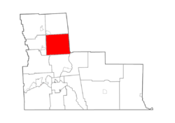
Map highlighting Barker's location within Broome County.
|
|
| Country | United States |
| State | New York |
| County | Broome |
| Government | |
| • Type | Town council |
| Area | |
| • Total | 41.78 sq mi (108.21 km2) |
| • Land | 41.40 sq mi (107.23 km2) |
| • Water | 0.38 sq mi (0.97 km2) |
| Elevation | 1,335 ft (407 m) |
| Population
(2020)
|
|
| • Total | 2,516 |
| • Estimate
(2021)
|
2,496 |
| • Density | 64.37/sq mi (24.85/km2) |
| Time zone | Eastern (EST) |
| FIPS code | 36-04429 |
| GNIS feature ID | 0978709 |
Barker is a small town in Broome County, New York. It is located in the northern part of Broome County. The town is named after John Barker, who was one of the first people to settle there. In 2020, about 2,516 people lived in Barker.
Contents
History of Barker
People first started settling in the Barker area around 1782. The town of Barker was officially created in 1831. It was formed from a part of the nearby town of Lisle.
Geography and Location
Barker covers a total area of about 108.2 square kilometers (41.8 square miles). Most of this area is land, with only a small part being water.
Neighboring Towns
Barker shares its borders with several other towns:
- To the north, it borders Triangle.
- To the northwest, it borders Lisle.
- To the west, it borders Nanticoke.
- To the southwest, it borders Maine.
- To the south, it borders Chenango.
- To the southeast, it borders Fenton.
- The eastern border of Barker is also the border of Chenango County.
Transportation and Rivers
Important roads like Interstate 81 and U.S. Route 11 pass through Barker. New York State Route 79 also runs through the town. The Tioughnioga River flows through Barker, adding to its natural beauty.
Barker is about 13 miles south of Binghamton. It is also about 27 miles north of Cortland.
Population Changes Over Time
| Historical population | |||
|---|---|---|---|
| Census | Pop. | %± | |
| 1840 | 1,259 | — | |
| 1850 | 1,456 | 15.6% | |
| 1860 | 1,090 | −25.1% | |
| 1870 | 1,396 | 28.1% | |
| 1880 | 1,333 | −4.5% | |
| 1890 | 1,100 | −17.5% | |
| 1900 | 1,072 | −2.5% | |
| 1910 | 948 | −11.6% | |
| 1920 | 1,003 | 5.8% | |
| 1930 | 992 | −1.1% | |
| 1940 | 1,223 | 23.3% | |
| 1950 | 1,456 | 19.1% | |
| 1960 | 1,683 | 15.6% | |
| 1970 | 2,032 | 20.7% | |
| 1980 | 2,244 | 10.4% | |
| 1990 | 2,714 | 20.9% | |
| 2000 | 2,738 | 0.9% | |
| 2010 | 2,732 | −0.2% | |
| 2020 | 2,516 | −7.9% | |
| 2021 (est.) | 2,496 | −8.6% | |
| U.S. Decennial Census | |||
The population of Barker has changed quite a bit over the years. In 1840, there were 1,259 people. The population grew steadily for many decades. It reached its highest point in 2000 with 2,738 residents. By 2020, the population was 2,516.
Communities and Other Places
Barker includes a few smaller communities and locations:
- Chenango Forks – Part of this small community is located at the southern edge of Barker.
- Hydeville – This is a small community on the western side of the town. You can find it on County Road 101.
- Itaska – This community is in the northeastern part of Barker. It is located along NY-79.
See also
 In Spanish: Barker (condado de Broome, Nueva York) para niños
 | Jewel Prestage |
 | Ella Baker |
 | Fannie Lou Hamer |


