Nichols (village), New York facts for kids
Quick facts for kids
Nichols, New York
|
|
|---|---|
|
Village
|
|

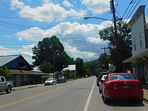
Nichols village on New York State Route 282.
|
|
| Country | United States |
| State | New York |
| County | Tioga |
| Settled | 1793 |
| Incorporated | 1903 |
| Named for | Early landowner |
| Area | |
| • Total | 0.52 sq mi (1.34 km2) |
| • Land | 0.52 sq mi (1.34 km2) |
| • Water | 0.00 sq mi (0.00 km2) |
| Elevation | 791 ft (241 m) |
| Population
(2020)
|
|
| • Total | 457 |
| • Density | 882.24/sq mi (340.35/km2) |
| Time zone | UTC-5 (Eastern (EST)) |
| • Summer (DST) | UTC-4 (EDT) |
| ZIP code |
13812
|
| Area code(s) | 607 |
| FIPS code | 36-51110 |
| GNIS feature ID | 0958556 |
Nichols is a small village in Tioga County, New York. It is located within the larger Town of Nichols. In 2020, about 457 people lived here.
The village is part of the Binghamton area. It was named after Colonel Nichols, an early landowner. The Village of Nichols is in the "Southern Tier" part of New York. It sits right on the northern edge of the town. Nichols is about halfway between the cities of Binghamton and Elmira.
History of Nichols
The area where Nichols is located has a long history. In 1779, a group called the Sullivan Expedition traveled through this region.
The village itself was settled around 1793. It was first known as "the Corners." For a short time, it was also called "Rushville." However, when Tioga County was created, the name was changed to "Nichols."
Two important buildings in Nichols are listed on the National Register of Historic Places. These are the Nichols High School and the Platt-Cady Mansion. They are recognized for their historical importance.
Geography of Nichols
Nichols is located at coordinates 42°1′11″N 76°22′6″W / 42.01972°N 76.36833°W. This helps pinpoint its exact spot on a map.
The United States Census Bureau says the village covers about 0.5 square miles (1.3 square kilometers). All of this area is land.
The Susquehanna River flows along the northern side of the village. A smaller stream called Wapasening Creek also joins the river right in Nichols.
Major roads pass through the village. These include the Southern Tier Expressway, which is also known as New York State Route 17 and will become Interstate 86. New York State Route 282 also goes through Nichols.
Population and People
| Historical population | |||
|---|---|---|---|
| Census | Pop. | %± | |
| 1910 | 533 | — | |
| 1920 | 554 | 3.9% | |
| 1930 | 533 | −3.8% | |
| 1940 | 541 | 1.5% | |
| 1950 | 578 | 6.8% | |
| 1960 | 663 | 14.7% | |
| 1970 | 638 | −3.8% | |
| 1980 | 613 | −3.9% | |
| 1990 | 573 | −6.5% | |
| 2000 | 574 | 0.2% | |
| 2010 | 512 | −10.8% | |
| 2020 | 457 | −10.7% | |
| US Decennial Census | |||
In 2000, there were 574 people living in Nichols. These people made up 213 households. About 152 of these were families. The village had about 1,124 people per square mile.
Many households had children under 18 living with them (38%). Most households (53.5%) were married couples. About 24.4% of households were individuals living alone. Some people aged 65 or older lived alone (15.5%).
The average household had 2.69 people. The average family had 3.08 people.
The population had a mix of ages. About 31.4% were under 18. About 14.5% were 65 or older. The average age in the village was 35 years old.
Education
Students in Nichols attend schools within the Tioga Central School District.
See also
 In Spanish: Nichols (villa) para niños
 | Jewel Prestage |
 | Ella Baker |
 | Fannie Lou Hamer |


